
Station YA CCPE2 - Cactus Peak E2
Network: YA98 - Coso Passive Short Period Arrays
Nearby stations (2 deg radius)
| Station | Name | (Lat, Lon) | Start / End | Elevation |
| CCPE2 | Cactus Peak E2 | (36.07, -117.80) | 1999-10-07 / 2000-12-31 | 1.4 km |
| Crust2 Type: | M7,medium thick extended crust, 0.5 km seds. |
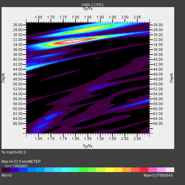
| Thickness Estimate: | 32 km |
| Thickness StdDev: | 1.5 km |
| Vp/Vs Estimate: | 1.79 |
| Vp/Vs StdDev: | 0.02 |
| Vs Estimate: | 3.517 km/s |
| Poisson's Ratio: | 0.27 |
| Peak Value: | 0.08 |
| Assumed Vp: | 6.279 km/s |
| Ps Weight: | 0.33333334 |
| PpPs Weight: | 0.33333334 |
| PsPs Weight: | 0.33333328 |
| Residual Complexity: | 0.516 |
| Nearby stations H: | 52 km +- 19 km |
| (2.0 deg) Vp/Vs: | 1.78 +- 0.18 |
0 with match > 90% ( 0.0 %) and 2 with match > 80% ( 100.0 %) out of 2.
Download stack as xyz text file.
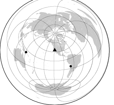
Azimuth Distribution of Events:
Prior Results for this Station
| Study | Thickness | Vp/Vs | Vp | Vs | Poissons Ratio | Extra |
| EARS | 32 km | 1.79 | 6.279 km/s | 3.517 km/s | 0.27 | |
| Crust2.0 | 35 km | 1.78 | 6.279 km/s | 3.533 km/s | 0.27 | M7,medium thick extended crust, 0.5 km seds. |
| Global Maxima | 32 km | 1.79 | 6.279 km/s | 3.517 km/s | 0.27 | amp=0.07980949 |
| Local Maxima 1 | 28 km | 1.81 | 6.279 km/s | 3.478 km/s | 0.28 | amp=0.041905366 |
| Local Maxima 2 | 26 km | 1.92 | 6.279 km/s | 3.262 km/s | 0.32 | amp=0.0317024 |
| Local Maxima 3 | 44 km | 1.61 | 6.279 km/s | 3.912 km/s | 0.18 | amp=0.02970821 |
| Local Maxima 4 | 56 km | 2.10 | 6.279 km/s | 2.993 km/s | 0.35 | amp=0.013564085 |
| Predicted Arrivals for vertical incidence (zero ray parameter) | |
| Ps | 4.06 SECOND |
| PpPs | 14.42 SECOND |
| PsPs/PpSs | 18.48 SECOND |
Events Processed for this Station
Download zip of receiver functions as SAC
Plot maxima for each earthquake.
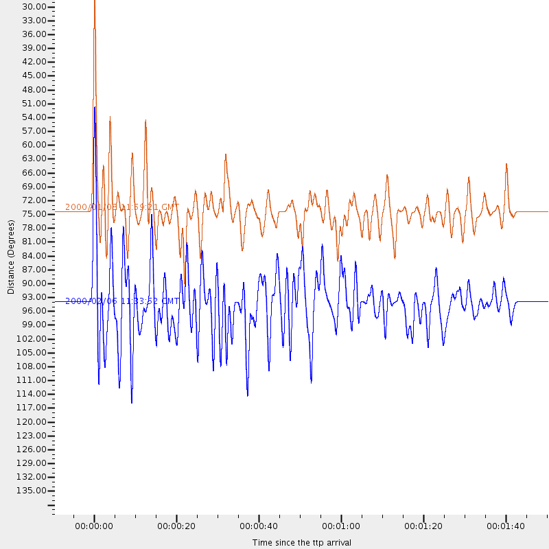
Events Used in the Stack
(2 events)| Radial Match | Distance | Baz | FERegion | Time | Lat/Lon | Depth | Magnitude |
| 82.57201 | 74.2 deg | 134.986 deg | Near Coast Of Northern Chile | 2000/01/08 11:59:21 GMT | (-23.2, -70.1) | 36 km | 5.8 MB, 5.9 MS, 6.4 MW, 6.1 ME |
| 82.02299 | 94.5 deg | 266.06 deg | New Britain Region, P.N.G. | 2000/02/06 11:33:52 GMT | (-5.8, 150.9) | 33 km | 6.6 MB, 6.8 MS, 6.6 MW, 6.3 ME |
Losers
(0 events)| Radial Match | Distance | Baz | FERegion | Time | Lat/Lon | Depth | Magnitude | Reason |
