
Station YA CCPE3 - Cactus Peak E3
Network: YA98 - Coso Passive Short Period Arrays
Nearby stations (2 deg radius)
| Station | Name | (Lat, Lon) | Start / End | Elevation |
| CCPE3 | Cactus Peak E3 | (36.07, -117.80) | 1999-09-26 / 2000-12-31 | 1.4 km |
| Crust2 Type: | M7,medium thick extended crust, 0.5 km seds. |
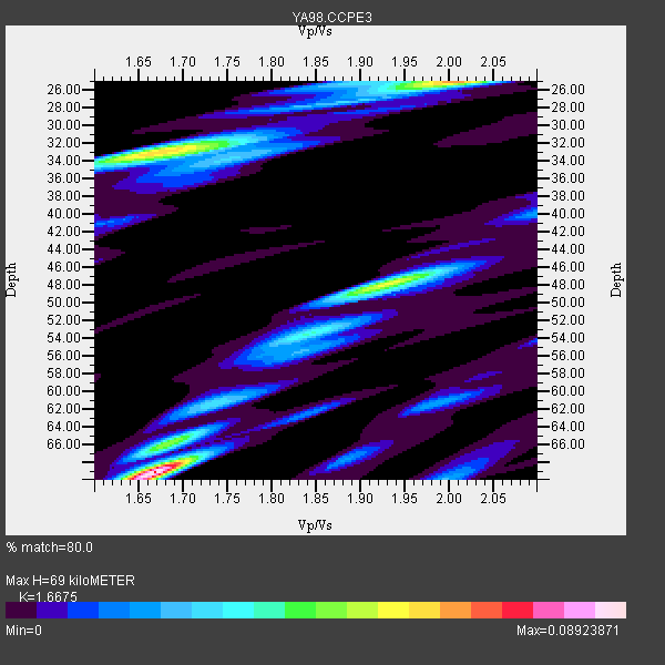
| Thickness Estimate: | 69 km |
| Thickness StdDev: | 12 km |
| Vp/Vs Estimate: | 1.67 |
| Vp/Vs StdDev: | 0.10 |
| Vs Estimate: | 3.765 km/s |
| Poisson's Ratio: | 0.22 |
| Peak Value: | 0.09 |
| Assumed Vp: | 6.279 km/s |
| Ps Weight: | 0.33333334 |
| PpPs Weight: | 0.33333334 |
| PsPs Weight: | 0.33333328 |
| Residual Complexity: | 0.823 |
| Nearby stations H: | 52 km +- 19 km |
| (2.0 deg) Vp/Vs: | 1.78 +- 0.18 |
3 with match > 90% ( 75.0 %) and 4 with match > 80% ( 100.0 %) out of 4.
Download stack as xyz text file.
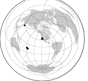
Azimuth Distribution of Events:
Prior Results for this Station
| Study | Thickness | Vp/Vs | Vp | Vs | Poissons Ratio | Extra |
| EARS | 69 km | 1.67 | 6.279 km/s | 3.765 km/s | 0.22 | |
| Crust2.0 | 35 km | 1.78 | 6.279 km/s | 3.533 km/s | 0.27 | M7,medium thick extended crust, 0.5 km seds. |
| Global Maxima | 69 km | 1.67 | 6.279 km/s | 3.765 km/s | 0.22 | amp=0.08923871 |
| Local Maxima 1 | 25 km | 2.00 | 6.279 km/s | 3.135 km/s | 0.33 | amp=0.065490864 |
| Local Maxima 2 | 33 km | 1.67 | 6.279 km/s | 3.765 km/s | 0.22 | amp=0.06026815 |
| Local Maxima 3 | 48 km | 1.93 | 6.279 km/s | 3.253 km/s | 0.32 | amp=0.05492057 |
| Local Maxima 4 | 66 km | 1.68 | 6.279 km/s | 3.732 km/s | 0.23 | amp=0.03228276 |
| Predicted Arrivals for vertical incidence (zero ray parameter) | |
| Ps | 7.34 SECOND |
| PpPs | 29.32 SECOND |
| PsPs/PpSs | 36.65 SECOND |
Events Processed for this Station
Download zip of receiver functions as SAC
Plot maxima for each earthquake.
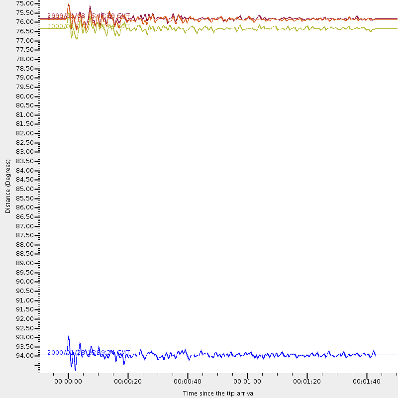
Events Used in the Stack
(4 events)| Radial Match | Distance | Baz | FERegion | Time | Lat/Lon | Depth | Magnitude |
| 94.7428 | 94.7 deg | 306.966 deg | Northeast Of Taiwan | 2000/01/28 16:39:24 GMT | (26.1, 124.5) | 194 km | 6.1 MB, 6.0 MW, 6.0 MW |
| 93.19956 | 75.1 deg | 235.259 deg | Tonga Islands | 2000/01/26 13:26:50 GMT | (-17.3, -174.0) | 33 km | 5.9 MB, 6.0 MS, 6.4 MW, 6.3 MW |
| 91.0126 | 75.0 deg | 235.683 deg | Tonga Islands | 2000/01/08 16:47:20 GMT | (-16.9, -174.2) | 183 km | 6.5 MB, 6.6 MS, 7.2 MW, 7.0 ME |
| 88.45007 | 75.6 deg | 239.79 deg | Fiji Islands Region | 2000/01/17 21:18:04 GMT | (-14.5, -177.6) | 33 km | 5.6 MB, 5.7 MS, 5.9 MW, 5.8 MW |
Losers
(0 events)| Radial Match | Distance | Baz | FERegion | Time | Lat/Lon | Depth | Magnitude | Reason |
