
Station YA CCPS5 - Cactus Peak S5
Network: YA98 - Coso Passive Short Period Arrays
Nearby stations (2 deg radius)
| Station | Name | (Lat, Lon) | Start / End | Elevation |
| CCPS5 | Cactus Peak S5 | (36.05, -117.83) | 1999-09-26 / 2000-12-31 | 1.3 km |
| Crust2 Type: | M7,medium thick extended crust, 0.5 km seds. |
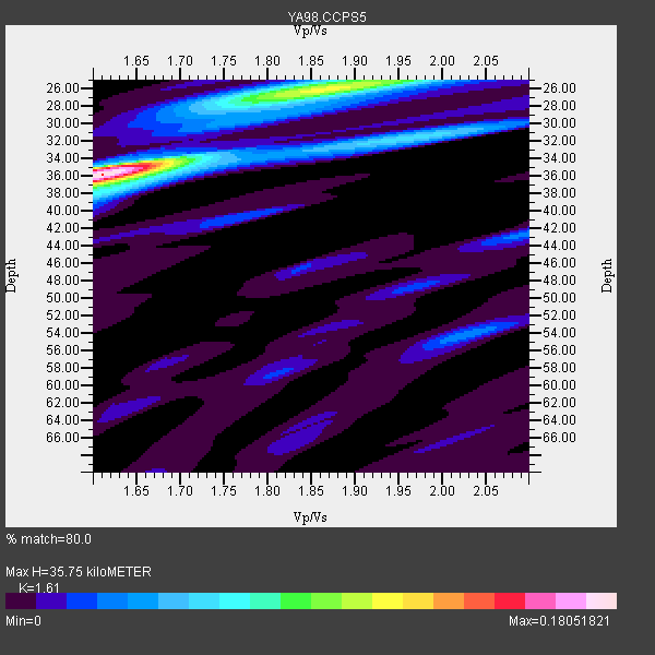
| Thickness Estimate: | 36 km |
| Thickness StdDev: | 4.2 km |
| Vp/Vs Estimate: | 1.61 |
| Vp/Vs StdDev: | 0.11 |
| Vs Estimate: | 3.9 km/s |
| Poisson's Ratio: | 0.19 |
| Peak Value: | 0.18 |
| Assumed Vp: | 6.279 km/s |
| Ps Weight: | 0.33333334 |
| PpPs Weight: | 0.33333334 |
| PsPs Weight: | 0.33333328 |
| Residual Complexity: | 0.638 |
| Nearby stations H: | +- |
| (2.0 deg) Vp/Vs: | +- |
1 with match > 90% ( 50.0 %) and 2 with match > 80% ( 100.0 %) out of 2.
Download stack as xyz text file.
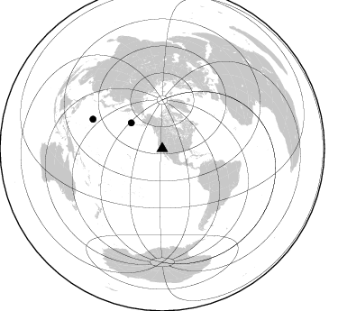
Azimuth Distribution of Events:
Prior Results for this Station
| Study | Thickness | Vp/Vs | Vp | Vs | Poissons Ratio | Extra |
| EARS | 36 km | 1.61 | 6.279 km/s | 3.9 km/s | 0.19 | |
| Crust2.0 | 35 km | 1.78 | 6.279 km/s | 3.533 km/s | 0.27 | M7,medium thick extended crust, 0.5 km seds. |
| Global Maxima | 36 km | 1.61 | 6.279 km/s | 3.9 km/s | 0.19 | amp=0.18051821 |
| Local Maxima 1 | 26 km | 1.87 | 6.279 km/s | 3.367 km/s | 0.30 | amp=0.10723096 |
| Local Maxima 2 | 35 km | 1.61 | 6.279 km/s | 3.9 km/s | 0.19 | amp=0.046208933 |
| Local Maxima 3 | 54 km | 2.03 | 6.279 km/s | 3.093 km/s | 0.34 | amp=0.033835556 |
| Local Maxima 4 | 42 km | 2.10 | 6.279 km/s | 2.993 km/s | 0.35 | amp=0.031699315 |
| Predicted Arrivals for vertical incidence (zero ray parameter) | |
| Ps | 3.47 SECOND |
| PpPs | 14.86 SECOND |
| PsPs/PpSs | 18.33 SECOND |
Events Processed for this Station
Download zip of receiver functions as SAC
Plot maxima for each earthquake.
Events Used in the Stack
(2 events)| Radial Match | Distance | Baz | FERegion | Time | Lat/Lon | Depth | Magnitude |
| 93.96101 | 83.6 deg | 292.847 deg | Volcano Islands, Japan Region | 2000/03/28 11:00:22 GMT | (22.3, 143.7) | 126 km | 6.8 MB, 7.6 MS, 7.6 MW, 7.6 MW |
| 83.13011 | 44.9 deg | 309.607 deg | Andreanof Islands, Aleutian Is. | 2000/04/21 04:35:17 GMT | (51.4, -178.1) | 33 km | 6.0 MB, 5.7 MS, 6.2 ML, 6.0 MW |
Losers
(0 events)| Radial Match | Distance | Baz | FERegion | Time | Lat/Lon | Depth | Magnitude | Reason |
