
Station YB BB12 - YB.BB12
Network: YB98 - South Africa Seismic Experiment - Kimberley Telemetered Array
Nearby stations (2 deg radius)
| Station | Name | (Lat, Lon) | Start / End | Elevation |
| BB12 | YB.BB12 | (-28.53, 24.71) | 1998-12-14 / 1999-07-02 | 2105 m |
| Crust2 Type: | G1,Archean, no seds. |
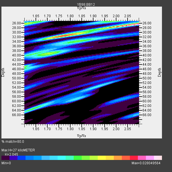
| Thickness Estimate: | 27 km |
| Thickness StdDev: | 7.4 km |
| Vp/Vs Estimate: | 2.05 |
| Vp/Vs StdDev: | 0.19 |
| Vs Estimate: | 3.159 km/s |
| Poisson's Ratio: | 0.34 |
| Peak Value: | 0.03 |
| Assumed Vp: | 6.459 km/s |
| Ps Weight: | 0.33333334 |
| PpPs Weight: | 0.33333334 |
| PsPs Weight: | 0.33333328 |
| Residual Complexity: | 0.782 |
| Nearby stations H: | +- |
| (2.0 deg) Vp/Vs: | +- |
1 with match > 90% ( 11.111111 %) and 2 with match > 80% ( 22.222221 %) out of 9.
Download stack as xyz text file.
Azimuth Distribution of Events:

Prior Results for this Station
| Study | Thickness | Vp/Vs | Vp | Vs | Poissons Ratio | Extra |
| EARS | 27 km | 2.05 | 6.459 km/s | 3.159 km/s | 0.34 | |
| Crust2.0 | 37 km | 1.76 | 6.459 km/s | 3.665 km/s | 0.26 | G1,Archean, no seds. |
| Global Maxima | 27 km | 2.05 | 6.459 km/s | 3.159 km/s | 0.34 | amp=0.028049564 |
| Local Maxima 1 | 32 km | 1.76 | 6.459 km/s | 3.665 km/s | 0.26 | amp=0.021222088 |
| Local Maxima 2 | 26 km | 1.60 | 6.459 km/s | 4.037 km/s | 0.18 | amp=0.016965315 |
| Local Maxima 3 | 39 km | 1.71 | 6.459 km/s | 3.777 km/s | 0.24 | amp=0.014765092 |
| Local Maxima 4 | 63 km | 1.63 | 6.459 km/s | 3.951 km/s | 0.20 | amp=0.01394956 |
| Predicted Arrivals for vertical incidence (zero ray parameter) | |
| Ps | 4.37 SECOND |
| PpPs | 12.73 SECOND |
| PsPs/PpSs | 17.10 SECOND |
Events Processed for this Station
Download zip of receiver functions as SAC
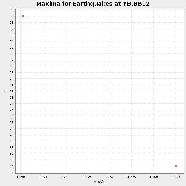
Plot maxima for each earthquake.
Events Used in the Stack
(2 events)| Radial Match | Distance | Baz | FERegion | Time | Lat/Lon | Depth | Magnitude |
| 91.84441 | 78.5 deg | 45.941 deg | Western Xizang-India Border Reg. | 1999/03/28 19:05:11 GMT | (30.5, 79.4) | 15 km | 6.4 MB, 6.6 MS, 6.6 MW, 6.5 ME |
| 83.82235 | 77.7 deg | 36.441 deg | Hindu Kush Region, Afghanistan | 1999/06/21 17:37:27 GMT | (36.4, 70.7) | 230 km | 5.6 MW, 5.4 MB, 5.5 MW |
Losers
(7 events)| Radial Match | Distance | Baz | FERegion | Time | Lat/Lon | Depth | Magnitude | Reason |
| 71.45856 | 82.1 deg | 248.537 deg | Northern Chile | 1999/03/02 17:45:55 GMT | (-22.7, -68.5) | 111 km | 5.8 MB, 6.1 MW, 5.9 MW | |
| 66.422676 | 74.2 deg | 16.65 deg | Eastern Caucasus | 1999/01/31 05:07:13 GMT | (43.2, 46.8) | 33 km | 5.8 MW, 5.4 MS, 5.3 MB, 5.7 MW | |
| 62.755928 | 63.3 deg | 26.465 deg | Southern Iran | 1999/05/06 23:00:53 GMT | (29.5, 51.9) | 33 km | 5.9 MB, 6.3 MS, 6.2 MW, 6.1 MW | |
| 60.46454 | 64.1 deg | 79.92 deg | South Indian Ocean | 1999/03/29 06:17:58 GMT | (-4.0, 87.3) | 10 km | 5.5 MS, 5.4 MB, 5.8 MW, 5.8 MW | |
| 60.403114 | 86.3 deg | 300.238 deg | Northern Mid-Atlantic Ridge | 1999/04/06 04:51:05 GMT | (24.5, -46.4) | 10 km | 5.6 MS, 5.3 MB, 5.9 MW, 5.8 MW | |
| 56.575527 | 92.9 deg | 285.438 deg | Leeward Islands | 1999/06/08 12:04:00 GMT | (15.0, -60.4) | 55 km | 5.8 MW, 5.3 MS, 5.3 MB, 5.8 MW | |
| 48.689796 | 80.2 deg | 249.492 deg | Jujuy Province, Argentina | 1999/06/09 23:25:01 GMT | (-22.8, -66.2) | 250 km | 5.5 MW, 5.3 MB |
