
Station YB BB15 - YB.BB15
Network: YB98 - South Africa Seismic Experiment - Kimberley Telemetered Array
Nearby stations (2 deg radius)
| Station | Name | (Lat, Lon) | Start / End | Elevation |
| BB15 | YB.BB15 | (-28.58, 24.90) | 1998-12-14 / 1999-07-02 | 2085 m |
| Crust2 Type: | G1,Archean, no seds. |
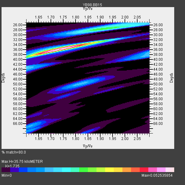
| Thickness Estimate: | 36 km |
| Thickness StdDev: | 3.2 km |
| Vp/Vs Estimate: | 1.74 |
| Vp/Vs StdDev: | 0.03 |
| Vs Estimate: | 3.723 km/s |
| Poisson's Ratio: | 0.25 |
| Peak Value: | 0.05 |
| Assumed Vp: | 6.459 km/s |
| Ps Weight: | 0.33333334 |
| PpPs Weight: | 0.33333334 |
| PsPs Weight: | 0.33333328 |
| Residual Complexity: | 0.590 |
| Nearby stations H: | +- |
| (2.0 deg) Vp/Vs: | +- |
1 with match > 90% ( 25.0 %) and 2 with match > 80% ( 50.0 %) out of 4.
Download stack as xyz text file.
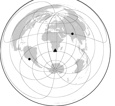
Azimuth Distribution of Events:
Prior Results for this Station
| Study | Thickness | Vp/Vs | Vp | Vs | Poissons Ratio | Extra |
| EARS | 36 km | 1.74 | 6.459 km/s | 3.723 km/s | 0.25 | |
| Crust2.0 | 37 km | 1.76 | 6.459 km/s | 3.665 km/s | 0.26 | G1,Archean, no seds. |
| Global Maxima | 36 km | 1.74 | 6.459 km/s | 3.723 km/s | 0.25 | amp=0.052535854 |
| Local Maxima 1 | 28 km | 1.88 | 6.459 km/s | 3.427 km/s | 0.30 | amp=0.02404018 |
| Local Maxima 2 | 33 km | 1.87 | 6.459 km/s | 3.454 km/s | 0.30 | amp=0.021125516 |
| Local Maxima 3 | 38 km | 2.10 | 6.459 km/s | 3.08 km/s | 0.35 | amp=0.015481706 |
| Local Maxima 4 | 38 km | 1.62 | 6.459 km/s | 3.993 km/s | 0.19 | amp=0.014641621 |
| Predicted Arrivals for vertical incidence (zero ray parameter) | |
| Ps | 4.07 SECOND |
| PpPs | 15.14 SECOND |
| PsPs/PpSs | 19.20 SECOND |
Events Processed for this Station
Download zip of receiver functions as SAC
Plot maxima for each earthquake.
Events Used in the Stack
(2 events)| Radial Match | Distance | Baz | FERegion | Time | Lat/Lon | Depth | Magnitude |
| 92.12502 | 78.4 deg | 45.821 deg | Western Xizang-India Border Reg. | 1999/03/28 19:05:11 GMT | (30.5, 79.4) | 15 km | 6.4 MB, 6.6 MS, 6.6 MW, 6.5 ME |
| 86.185196 | 88.6 deg | 251.899 deg | Near Coast Of Peru | 1999/04/03 06:17:18 GMT | (-16.7, -72.7) | 87 km | 6.1 MB, 6.2 MS, 6.8 MW, 6.8 MW |
Losers
(2 events)| Radial Match | Distance | Baz | FERegion | Time | Lat/Lon | Depth | Magnitude | Reason |
| 68.57674 | 82.3 deg | 248.463 deg | Northern Chile | 1999/03/02 17:45:55 GMT | (-22.7, -68.5) | 111 km | 5.8 MB, 6.1 MW, 5.9 MW | |
| 53.425926 | 63.9 deg | 79.791 deg | South Indian Ocean | 1999/03/29 06:17:58 GMT | (-4.0, 87.3) | 10 km | 5.5 MS, 5.4 MB, 5.8 MW, 5.8 MW |
