
Station YB BB17 - YB.BB17
Network: YB98 - South Africa Seismic Experiment - Kimberley Telemetered Array
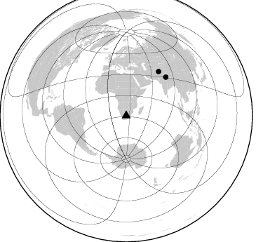
Nearby stations (2 deg radius)
| Station | Name | (Lat, Lon) | Start / End | Elevation |
| BB17 | YB.BB17 | (-28.56, 24.71) | 1998-12-14 / 1999-07-02 | 1802 m |
| Crust2 Type: | G1,Archean, no seds. |
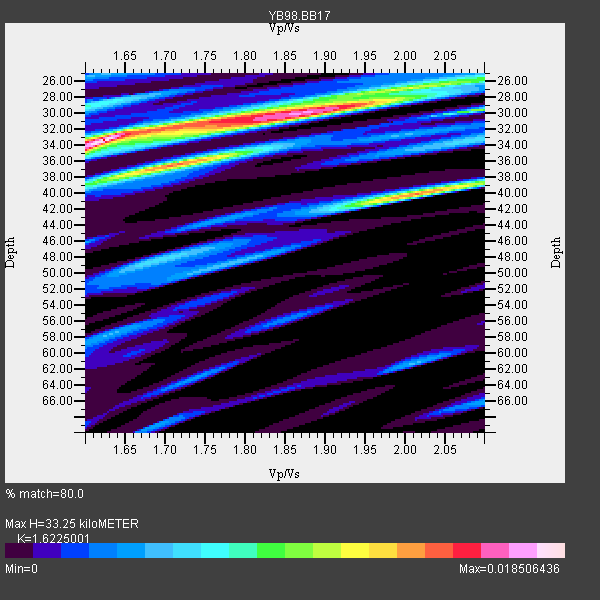
| Thickness Estimate: | 33 km |
| Thickness StdDev: | 0.7 km |
| Vp/Vs Estimate: | 1.62 |
| Vp/Vs StdDev: | 0.07 |
| Vs Estimate: | 3.981 km/s |
| Poisson's Ratio: | 0.19 |
| Peak Value: | 0.02 |
| Assumed Vp: | 6.459 km/s |
| Ps Weight: | 0.33333334 |
| PpPs Weight: | 0.33333334 |
| PsPs Weight: | 0.33333328 |
| Residual Complexity: | 0.778 |
| Nearby stations H: | +- |
| (2.0 deg) Vp/Vs: | +- |
0 with match > 90% ( 0.0 %) and 2 with match > 80% ( 25.0 %) out of 8.
Download stack as xyz text file.
Azimuth Distribution of Events:
Prior Results for this Station
| Study | Thickness | Vp/Vs | Vp | Vs | Poissons Ratio | Extra |
| EARS | 33 km | 1.62 | 6.459 km/s | 3.981 km/s | 0.19 | |
| Crust2.0 | 37 km | 1.76 | 6.459 km/s | 3.665 km/s | 0.26 | G1,Archean, no seds. |
| Global Maxima | 33 km | 1.62 | 6.459 km/s | 3.981 km/s | 0.19 | amp=0.018506436 |
| Local Maxima 1 | 30 km | 1.89 | 6.459 km/s | 3.422 km/s | 0.30 | amp=0.014322023 |
| Local Maxima 2 | 40 km | 2.01 | 6.459 km/s | 3.21 km/s | 0.34 | amp=0.013968875 |
| Local Maxima 3 | 37 km | 1.69 | 6.459 km/s | 3.822 km/s | 0.23 | amp=0.01157368 |
| Local Maxima 4 | 30 km | 2.09 | 6.459 km/s | 3.094 km/s | 0.35 | amp=0.009383309 |
| Predicted Arrivals for vertical incidence (zero ray parameter) | |
| Ps | 3.20 SECOND |
| PpPs | 13.50 SECOND |
| PsPs/PpSs | 16.70 SECOND |
Events Processed for this Station
Download zip of receiver functions as SAC
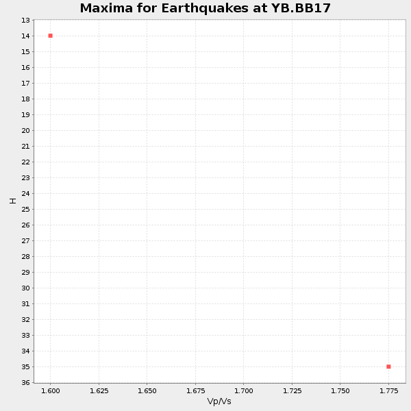
Plot maxima for each earthquake.
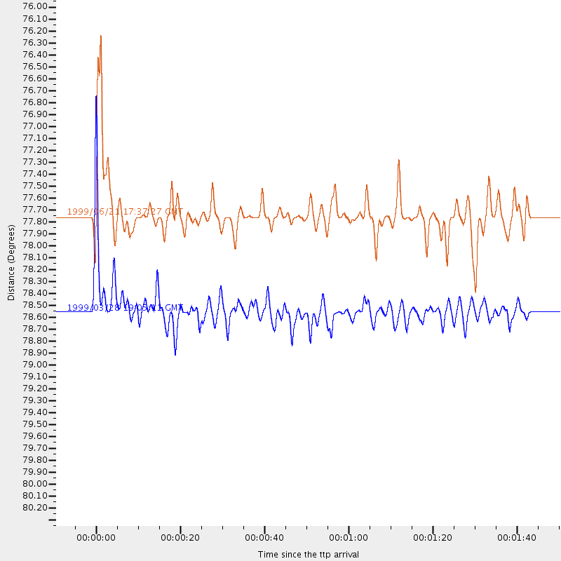
Events Used in the Stack
(2 events)| Radial Match | Distance | Baz | FERegion | Time | Lat/Lon | Depth | Magnitude |
| 89.73975 | 78.6 deg | 45.938 deg | Western Xizang-India Border Reg. | 1999/03/28 19:05:11 GMT | (30.5, 79.4) | 15 km | 6.4 MB, 6.6 MS, 6.6 MW, 6.5 ME |
| 84.434395 | 77.8 deg | 36.439 deg | Hindu Kush Region, Afghanistan | 1999/06/21 17:37:27 GMT | (36.4, 70.7) | 230 km | 5.6 MW, 5.4 MB, 5.5 MW |
Losers
(6 events)| Radial Match | Distance | Baz | FERegion | Time | Lat/Lon | Depth | Magnitude | Reason |
| 70.91625 | 82.1 deg | 248.542 deg | Northern Chile | 1999/03/02 17:45:55 GMT | (-22.7, -68.5) | 111 km | 5.8 MB, 6.1 MW, 5.9 MW | |
| 67.758644 | 88.4 deg | 251.987 deg | Near Coast Of Peru | 1999/04/03 06:17:18 GMT | (-16.7, -72.7) | 87 km | 6.1 MB, 6.2 MS, 6.8 MW, 6.8 MW | |
| 65.15734 | 64.6 deg | 31.615 deg | Southern Iran | 1999/03/04 05:38:26 GMT | (28.3, 57.2) | 33 km | 6.2 MB, 6.5 MS, 6.6 MW, 6.4 MW | |
| 40.737106 | 94.3 deg | 92.128 deg | Minahassa Peninsula, Sulawesi | 1999/02/23 07:27:56 GMT | (0.2, 119.5) | 33 km | 5.6 MB, 5.8 MS | |
| 40.467667 | 74.2 deg | 16.65 deg | Eastern Caucasus | 1999/01/31 05:07:13 GMT | (43.2, 46.8) | 33 km | 5.8 MW, 5.4 MS, 5.3 MB, 5.7 MW | |
| 37.764915 | 64.1 deg | 79.907 deg | South Indian Ocean | 1999/03/29 06:17:58 GMT | (-4.0, 87.3) | 10 km | 5.5 MS, 5.4 MB, 5.8 MW, 5.8 MW |
