
Station YB BB19 - YB.BB19
Network: YB98 - South Africa Seismic Experiment - Kimberley Telemetered Array
Nearby stations (2 deg radius)
| Station | Name | (Lat, Lon) | Start / End | Elevation |
| BB19 | YB.BB19 | (-28.60, 24.83) | 1998-12-14 / 1999-07-02 | 2153 m |
| Crust2 Type: | G1,Archean, no seds. |
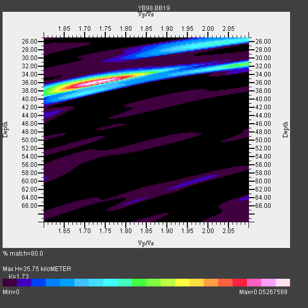
| Thickness Estimate: | 36 km |
| Thickness StdDev: | 0.5 km |
| Vp/Vs Estimate: | 1.73 |
| Vp/Vs StdDev: | 0.01 |
| Vs Estimate: | 3.734 km/s |
| Poisson's Ratio: | 0.25 |
| Peak Value: | 0.05 |
| Assumed Vp: | 6.459 km/s |
| Ps Weight: | 0.33333334 |
| PpPs Weight: | 0.33333334 |
| PsPs Weight: | 0.33333328 |
| Residual Complexity: | 0.395 |
| Nearby stations H: | +- |
| (2.0 deg) Vp/Vs: | +- |
1 with match > 90% ( 11.111111 %) and 2 with match > 80% ( 22.222221 %) out of 9.
Download stack as xyz text file.
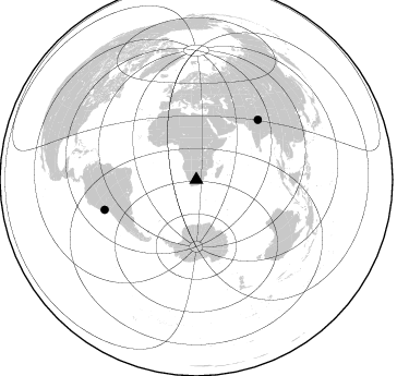
Azimuth Distribution of Events:
Prior Results for this Station
| Study | Thickness | Vp/Vs | Vp | Vs | Poissons Ratio | Extra |
| EARS | 36 km | 1.73 | 6.459 km/s | 3.734 km/s | 0.25 | |
| Crust2.0 | 37 km | 1.76 | 6.459 km/s | 3.665 km/s | 0.26 | G1,Archean, no seds. |
| Global Maxima | 36 km | 1.73 | 6.459 km/s | 3.734 km/s | 0.25 | amp=0.05267589 |
| Local Maxima 1 | 26 km | 2.02 | 6.459 km/s | 3.194 km/s | 0.34 | amp=0.020080809 |
| Local Maxima 2 | 31 km | 2.10 | 6.459 km/s | 3.08 km/s | 0.35 | amp=0.016543837 |
| Local Maxima 3 | 39 km | 1.60 | 6.459 km/s | 4.037 km/s | 0.18 | amp=0.01163997 |
| Local Maxima 4 | 35 km | 1.70 | 6.459 km/s | 3.805 km/s | 0.23 | amp=0.0057899063 |
| Predicted Arrivals for vertical incidence (zero ray parameter) | |
| Ps | 4.04 SECOND |
| PpPs | 15.11 SECOND |
| PsPs/PpSs | 19.15 SECOND |
Events Processed for this Station
Download zip of receiver functions as SAC
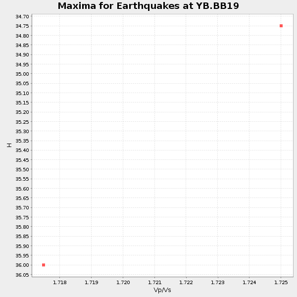
Plot maxima for each earthquake.
Events Used in the Stack
(2 events)| Radial Match | Distance | Baz | FERegion | Time | Lat/Lon | Depth | Magnitude |
| 94.425514 | 78.5 deg | 45.857 deg | Western Xizang-India Border Reg. | 1999/03/28 19:05:11 GMT | (30.5, 79.4) | 15 km | 6.4 MB, 6.6 MS, 6.6 MW, 6.5 ME |
| 82.914375 | 88.5 deg | 251.93 deg | Near Coast Of Peru | 1999/04/03 06:17:18 GMT | (-16.7, -72.7) | 87 km | 6.1 MB, 6.2 MS, 6.8 MW, 6.8 MW |
Losers
(7 events)| Radial Match | Distance | Baz | FERegion | Time | Lat/Lon | Depth | Magnitude | Reason |
| 75.718834 | 82.2 deg | 248.493 deg | Northern Chile | 1999/03/02 17:45:55 GMT | (-22.7, -68.5) | 111 km | 5.8 MB, 6.1 MW, 5.9 MW | |
| 60.881336 | 80.9 deg | 91.652 deg | Java, Indonesia | 1999/03/07 01:32:27 GMT | (-5.8, 107.6) | 325 km | 5.6 MW, 5.0 MB | |
| 57.419018 | 93.0 deg | 285.378 deg | Leeward Islands | 1999/06/08 12:04:00 GMT | (15.0, -60.4) | 55 km | 5.8 MW, 5.3 MS, 5.3 MB, 5.8 MW | |
| 53.23716 | 64.0 deg | 79.818 deg | South Indian Ocean | 1999/03/29 06:17:58 GMT | (-4.0, 87.3) | 10 km | 5.5 MS, 5.4 MB, 5.8 MW, 5.8 MW | |
| 50.510303 | 77.7 deg | 237.263 deg | Chile-Argentina Border Region | 1999/03/05 03:35:14 GMT | (-34.7, -69.6) | 10 km | 5.5 MS, 5.2 MB | |
| 30.179434 | 77.8 deg | 90.41 deg | Sunda Strait, Indonesia | 1999/02/03 06:35:56 GMT | (-6.2, 104.2) | 33 km | 5.6 MB, 5.6 MS, 5.8 MW, 5.7 MW | |
| 27.759655 | 74.2 deg | 16.557 deg | Eastern Caucasus | 1999/01/31 05:07:13 GMT | (43.2, 46.8) | 33 km | 5.8 MW, 5.4 MS, 5.3 MB, 5.7 MW |
