
Station YB BB23 - YB.BB23
Network: YB98 - South Africa Seismic Experiment - Kimberley Telemetered Array
Nearby stations (2 deg radius)

| Station | Name | (Lat, Lon) | Start / End | Elevation |
| BB23 | YB.BB23 | (-28.65, 24.82) | 1998-12-14 / 1999-07-02 | 2097 m |
| Crust2 Type: | G1,Archean, no seds. |
| Thickness Estimate: | 38 km |
| Thickness StdDev: | 3.4 km |
| Vp/Vs Estimate: | 1.62 |
| Vp/Vs StdDev: | 0.20 |
| Vs Estimate: | 3.981 km/s |
| Poisson's Ratio: | 0.19 |
| Peak Value: | 0.02 |
| Assumed Vp: | 6.459 km/s |
| Ps Weight: | 0.33333334 |
| PpPs Weight: | 0.33333334 |
| PsPs Weight: | 0.33333328 |
| Residual Complexity: | 0.637 |
| Nearby stations H: | +- |
| (2.0 deg) Vp/Vs: | +- |
2 with match > 90% ( 40.0 %) and 2 with match > 80% ( 40.0 %) out of 5.
Download stack as xyz text file.
Azimuth Distribution of Events:
Prior Results for this Station
| Study | Thickness | Vp/Vs | Vp | Vs | Poissons Ratio | Extra |
| EARS | 38 km | 1.62 | 6.459 km/s | 3.981 km/s | 0.19 | |
| Crust2.0 | 37 km | 1.76 | 6.459 km/s | 3.665 km/s | 0.26 | G1,Archean, no seds. |
| Global Maxima | 38 km | 1.62 | 6.459 km/s | 3.981 km/s | 0.19 | amp=0.015090719 |
| Local Maxima 1 | 35 km | 1.81 | 6.459 km/s | 3.574 km/s | 0.28 | amp=0.010422217 |
| Local Maxima 2 | 64 km | 1.72 | 6.459 km/s | 3.761 km/s | 0.24 | amp=0.006772654 |
| Local Maxima 3 | 70 km | 1.85 | 6.459 km/s | 3.496 km/s | 0.29 | amp=0.004630503 |
| Local Maxima 4 | 70 km | 1.60 | 6.459 km/s | 4.031 km/s | 0.18 | amp=0.004247596 |
| Predicted Arrivals for vertical incidence (zero ray parameter) | |
| Ps | 3.61 SECOND |
| PpPs | 15.22 SECOND |
| PsPs/PpSs | 18.84 SECOND |
Events Processed for this Station
Download zip of receiver functions as SAC
Plot maxima for each earthquake.
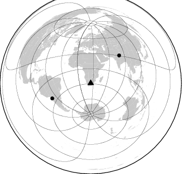
Events Used in the Stack
(2 events)| Radial Match | Distance | Baz | FERegion | Time | Lat/Lon | Depth | Magnitude |
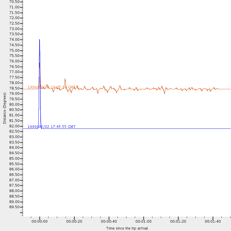
| 100.0 | 82.2 deg | 248.503 deg | Northern Chile | 1999/03/02 17:45:55 GMT | (-22.7, -68.5) | 111 km | 5.8 MB, 6.1 MW, 5.9 MW |
| 92.82427 | 78.5 deg | 45.856 deg | Western Xizang-India Border Reg. | 1999/03/28 19:05:11 GMT | (30.5, 79.4) | 15 km | 6.4 MB, 6.6 MS, 6.6 MW, 6.5 ME |
Losers
(3 events)| Radial Match | Distance | Baz | FERegion | Time | Lat/Lon | Depth | Magnitude | Reason |
| 52.73077 | 64.0 deg | 79.802 deg | South Indian Ocean | 1999/03/29 06:17:58 GMT | (-4.0, 87.3) | 10 km | 5.5 MS, 5.4 MB, 5.8 MW, 5.8 MW | |
| 51.54815 | 94.2 deg | 92.079 deg | Minahassa Peninsula, Sulawesi | 1999/02/23 07:27:56 GMT | (0.2, 119.5) | 33 km | 5.6 MB, 5.8 MS | |
| 39.09164 | 77.8 deg | 90.405 deg | Sunda Strait, Indonesia | 1999/02/03 06:35:56 GMT | (-6.2, 104.2) | 33 km | 5.6 MB, 5.6 MS, 5.8 MW, 5.7 MW |
