
Station YB BB28 - YB.BB28
Network: YB98 - South Africa Seismic Experiment - Kimberley Telemetered Array
Nearby stations (2 deg radius)
| Station | Name | (Lat, Lon) | Start / End | Elevation |
| BB28 | YB.BB28 | (-28.69, 24.56) | 1998-12-14 / 1999-07-02 | 1815 m |
| Crust2 Type: | G1,Archean, no seds. |
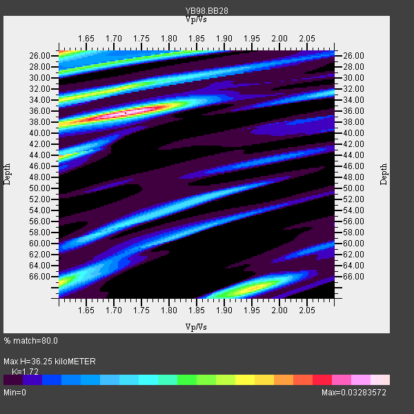
| Thickness Estimate: | 36 km |
| Thickness StdDev: | 13 km |
| Vp/Vs Estimate: | 1.72 |
| Vp/Vs StdDev: | 0.09 |
| Vs Estimate: | 3.755 km/s |
| Poisson's Ratio: | 0.24 |
| Peak Value: | 0.03 |
| Assumed Vp: | 6.459 km/s |
| Ps Weight: | 0.33333334 |
| PpPs Weight: | 0.33333334 |
| PsPs Weight: | 0.33333328 |
| Residual Complexity: | 0.770 |
| Nearby stations H: | +- |
| (2.0 deg) Vp/Vs: | +- |
1 with match > 90% ( 20.0 %) and 2 with match > 80% ( 40.0 %) out of 5.
Download stack as xyz text file.
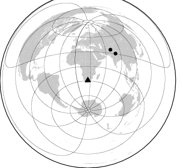
Azimuth Distribution of Events:
Prior Results for this Station
| Study | Thickness | Vp/Vs | Vp | Vs | Poissons Ratio | Extra |
| EARS | 36 km | 1.72 | 6.459 km/s | 3.755 km/s | 0.24 | |
| Crust2.0 | 37 km | 1.76 | 6.459 km/s | 3.665 km/s | 0.26 | G1,Archean, no seds. |
| Global Maxima | 36 km | 1.72 | 6.459 km/s | 3.755 km/s | 0.24 | amp=0.03283572 |
| Local Maxima 1 | 25 km | 1.60 | 6.459 km/s | 4.037 km/s | 0.18 | amp=0.025897855 |
| Local Maxima 2 | 67 km | 1.60 | 6.459 km/s | 4.037 km/s | 0.18 | amp=0.021799529 |
| Local Maxima 3 | 68 km | 1.95 | 6.459 km/s | 3.308 km/s | 0.32 | amp=0.021750797 |
| Local Maxima 4 | 34 km | 1.60 | 6.459 km/s | 4.037 km/s | 0.18 | amp=0.020607688 |
| Predicted Arrivals for vertical incidence (zero ray parameter) | |
| Ps | 4.04 SECOND |
| PpPs | 15.26 SECOND |
| PsPs/PpSs | 19.31 SECOND |
Events Processed for this Station
Download zip of receiver functions as SAC
Plot maxima for each earthquake.
Events Used in the Stack
(2 events)| Radial Match | Distance | Baz | FERegion | Time | Lat/Lon | Depth | Magnitude |
| 95.627884 | 78.7 deg | 46.006 deg | Western Xizang-India Border Reg. | 1999/03/28 19:05:11 GMT | (30.5, 79.4) | 15 km | 6.4 MB, 6.6 MS, 6.6 MW, 6.5 ME |
| 85.361984 | 77.9 deg | 36.513 deg | Hindu Kush Region, Afghanistan | 1999/06/21 17:37:27 GMT | (36.4, 70.7) | 230 km | 5.6 MW, 5.4 MB, 5.5 MW |
Losers
(3 events)| Radial Match | Distance | Baz | FERegion | Time | Lat/Lon | Depth | Magnitude | Reason |
| 71.47287 | 81.9 deg | 248.623 deg | Northern Chile | 1999/03/02 17:45:55 GMT | (-22.7, -68.5) | 111 km | 5.8 MB, 6.1 MW, 5.9 MW | |
| 60.347218 | 64.8 deg | 31.703 deg | Southern Iran | 1999/03/04 05:38:26 GMT | (28.3, 57.2) | 33 km | 6.2 MB, 6.5 MS, 6.6 MW, 6.4 MW | |
| 47.926826 | 64.2 deg | 79.923 deg | South Indian Ocean | 1999/03/29 06:17:58 GMT | (-4.0, 87.3) | 10 km | 5.5 MS, 5.4 MB, 5.8 MW, 5.8 MW |
