
Station YJ AREE - Areriti High School
Network: YJ01 - Ethiopia-Afar Geoscientific Lithospheric Experiment
Nearby stations (2 deg radius)
| Station | Name | (Lat, Lon) | Start / End | Elevation |
| AREE | Areriti High School | (8.94, 39.42) | 2001-10-30 / 2003-01-30 | 1826 m |
| Crust2 Type: | G9,thin custal Archean 0.1 km seds., South American |
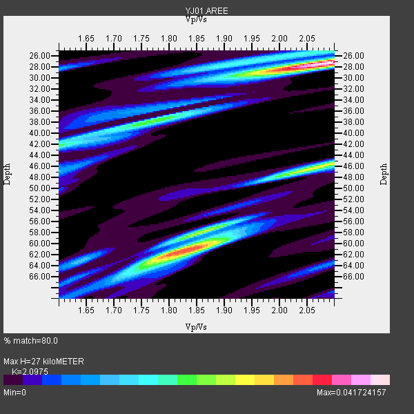
| Thickness Estimate: | 27 km |
| Thickness StdDev: | 15 km |
| Vp/Vs Estimate: | 2.10 |
| Vp/Vs StdDev: | 0.22 |
| Vs Estimate: | 3.082 km/s |
| Poisson's Ratio: | 0.35 |
| Peak Value: | 0.04 |
| Assumed Vp: | 6.464 km/s |
| Ps Weight: | 0.33333334 |
| PpPs Weight: | 0.33333334 |
| PsPs Weight: | 0.33333328 |
| Residual Complexity: | 0.792 |
| Nearby stations H: | +- |
| (2.0 deg) Vp/Vs: | +- |
0 with match > 90% ( 0.0 %) and 2 with match > 80% ( 50.0 %) out of 4.
Download stack as xyz text file.
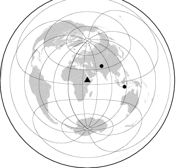
Azimuth Distribution of Events:
Prior Results for this Station
| Study | Thickness | Vp/Vs | Vp | Vs | Poissons Ratio | Extra |
| EARS | 27 km | 2.10 | 6.464 km/s | 3.082 km/s | 0.35 | |
| Crust2.0 | 31 km | 1.76 | 6.464 km/s | 3.663 km/s | 0.26 | G9,thin custal Archean 0.1 km seds., South American |
| Global Maxima | 27 km | 2.10 | 6.464 km/s | 3.082 km/s | 0.35 | amp=0.041724157 |
| Local Maxima 1 | 61 km | 1.82 | 6.464 km/s | 3.547 km/s | 0.28 | amp=0.0330513 |
| Local Maxima 2 | 46 km | 2.06 | 6.464 km/s | 3.138 km/s | 0.35 | amp=0.026195537 |
| Local Maxima 3 | 42 km | 1.60 | 6.464 km/s | 4.04 km/s | 0.18 | amp=0.01960358 |
| Local Maxima 4 | 38 km | 1.78 | 6.464 km/s | 3.631 km/s | 0.27 | amp=0.017120998 |
| Predicted Arrivals for vertical incidence (zero ray parameter) | |
| Ps | 4.58 SECOND |
| PpPs | 12.94 SECOND |
| PsPs/PpSs | 17.52 SECOND |
Events Processed for this Station
Download zip of receiver functions as SAC
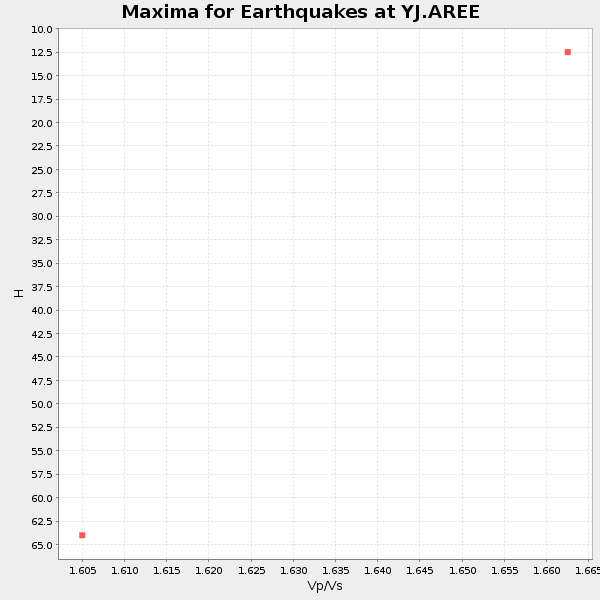
Plot maxima for each earthquake.
Events Used in the Stack
(2 events)| Radial Match | Distance | Baz | FERegion | Time | Lat/Lon | Depth | Magnitude |
| 82.74706 | 41.5 deg | 45.172 deg | Northwestern Kashmir | 2002/11/20 21:32:30 GMT | (35.4, 74.5) | 33 km | 5.7 MB, 6.5 MS, 6.4 MW, 6.0 MW |
| 82.665375 | 77.7 deg | 99.719 deg | Bali Sea | 2002/10/03 19:05:10 GMT | (-7.5, 115.7) | 316 km | 6.0 MB, 6.0 MW, 6.0 MW |
Losers
(2 events)| Radial Match | Distance | Baz | FERegion | Time | Lat/Lon | Depth | Magnitude | Reason |
| 77.5689 | 94.1 deg | 49.793 deg | Near East Coast Of Honshu, Japan | 2002/11/03 03:37:42 GMT | (38.9, 142.0) | 39 km | 5.7 MB, 6.1 MS, 6.4 MW, 6.4 MW | |
| 36.162468 | 95.0 deg | 90.953 deg | Irian Jaya Region, Indonesia | 2002/10/10 11:05:15 GMT | (-1.7, 134.2) | 10 km | 5.5 MB |
