
Station YJ ASEE - Asela High School
Network: YJ01 - Ethiopia-Afar Geoscientific Lithospheric Experiment
Nearby stations (2 deg radius)

| Station | Name | (Lat, Lon) | Start / End | Elevation |
| ASEE | Asela High School | (7.97, 39.13) | 2002-04-16 / 2003-01-18 | 2333 m |
| Crust2 Type: | G9,thin custal Archean 0.1 km seds., South American |
| Thickness Estimate: | 55 km |
| Thickness StdDev: | 7.8 km |
| Vp/Vs Estimate: | 1.63 |
| Vp/Vs StdDev: | 0.15 |
| Vs Estimate: | 3.953 km/s |
| Poisson's Ratio: | 0.20 |
| Peak Value: | 0.03 |
| Assumed Vp: | 6.464 km/s |
| Ps Weight: | 0.33333334 |
| PpPs Weight: | 0.33333334 |
| PsPs Weight: | 0.33333328 |
| Residual Complexity: | 0.834 |
| Nearby stations H: | 46 km +- 12 km |
| (2.0 deg) Vp/Vs: | 1.74 +- 0.16 |
1 with match > 90% ( 14.285714 %) and 6 with match > 80% ( 85.71429 %) out of 7.
Download stack as xyz text file.
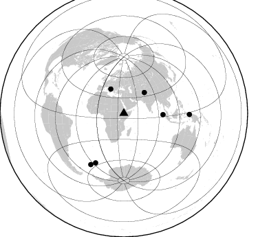
Azimuth Distribution of Events:
Prior Results for this Station
| Study | Thickness | Vp/Vs | Vp | Vs | Poissons Ratio | Extra |
| EARS | 55 km | 1.63 | 6.464 km/s | 3.953 km/s | 0.20 | |
| Crust2.0 | 31 km | 1.76 | 6.464 km/s | 3.663 km/s | 0.26 | G9,thin custal Archean 0.1 km seds., South American |
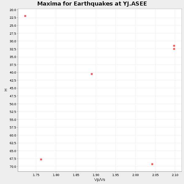
| Global Maxima | 55 km | 1.63 | 6.464 km/s | 3.953 km/s | 0.20 | amp=0.029072555 |
| Local Maxima 1 | 41 km | 1.84 | 6.464 km/s | 3.513 km/s | 0.29 | amp=0.025758607 |
| Local Maxima 2 | 41 km | 1.90 | 6.464 km/s | 3.397 km/s | 0.31 | amp=0.012427809 |
| Local Maxima 3 | 58 km | 1.84 | 6.464 km/s | 3.518 km/s | 0.29 | amp=0.011409528 |
| Local Maxima 4 | 40 km | 1.83 | 6.464 km/s | 3.542 km/s | 0.29 | amp=0.010904002 |
| Predicted Arrivals for vertical incidence (zero ray parameter) | |
| Ps | 5.40 SECOND |
| PpPs | 22.42 SECOND |
| PsPs/PpSs | 27.83 SECOND |
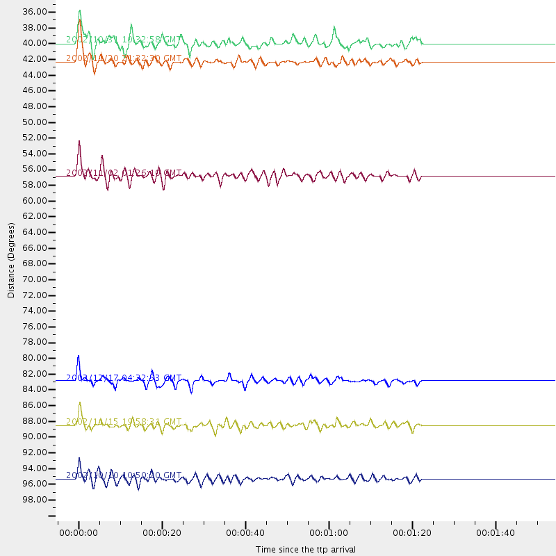
Events Processed for this Station
Download zip of receiver functions as SAC
Plot maxima for each earthquake.
Events Used in the Stack
(6 events)| Radial Match | Distance | Baz | FERegion | Time | Lat/Lon | Depth | Magnitude |
| 90.72161 | 56.9 deg | 91.818 deg | Northern Sumatra, Indonesia | 2002/11/02 01:26:10 GMT | (2.8, 96.1) | 30 km | 6.2 MB, 7.6 MS, 7.4 MW, 7.4 MW |
| 88.8289 | 88.6 deg | 212.917 deg | South Georgia Island Region | 2002/11/15 19:58:31 GMT | (-56.1, -36.4) | 10 km | 6.1 MB, 6.6 MS, 6.7 MW, 6.4 MW |
| 85.72618 | 82.9 deg | 209.739 deg | South Sandwich Islands Region | 2002/12/17 04:32:53 GMT | (-57.0, -24.8) | 10 km | 5.4 MB, 6.3 MS, 6.2 MW, 6.0 MW |
| 85.18066 | 95.4 deg | 91.022 deg | Irian Jaya Region, Indonesia | 2002/10/10 10:50:20 GMT | (-1.8, 134.3) | 10 km | 6.5 MB, 7.7 MS, 7.6 MW, 7.4 MW |
| 81.12412 | 39.9 deg | 331.403 deg | Southern Italy | 2002/10/31 10:32:58 GMT | (41.8, 14.9) | 10 km | 5.3 MB, 5.6 MS, 5.9 MW, 5.7 MW |
| 80.803345 | 42.3 deg | 44.6 deg | Northwestern Kashmir | 2002/11/20 21:32:30 GMT | (35.4, 74.5) | 33 km | 5.7 MB, 6.5 MS, 6.4 MW, 6.0 MW |
Losers
(1 events)| Radial Match | Distance | Baz | FERegion | Time | Lat/Lon | Depth | Magnitude | Reason |
| 68.99525 | 95.4 deg | 40.32 deg | Northwest Of Kuril Islands | 2002/11/17 04:53:53 GMT | (47.8, 146.2) | 459 km | 7.3 MW, 7.3 MW |
