
Station YJ BORE - Borechota Junior School
Network: YJ01 - Ethiopia-Afar Geoscientific Lithospheric Experiment
Nearby stations (2 deg radius)
| Station | Name | (Lat, Lon) | Start / End | Elevation |
| BORE | Borechota Junior School | (8.75, 39.55) | 2001-11-08 / 2003-01-31 | 1253 m |
| Crust2 Type: | G9,thin custal Archean 0.1 km seds., South American |
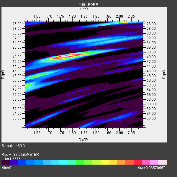
| Thickness Estimate: | 40 km |
| Thickness StdDev: | 5.3 km |
| Vp/Vs Estimate: | 1.78 |
| Vp/Vs StdDev: | 0.13 |
| Vs Estimate: | 3.636 km/s |
| Poisson's Ratio: | 0.27 |
| Peak Value: | 0.07 |
| Assumed Vp: | 6.464 km/s |
| Ps Weight: | 0.33333334 |
| PpPs Weight: | 0.33333334 |
| PsPs Weight: | 0.33333328 |
| Residual Complexity: | 0.589 |
| Nearby stations H: | +- |
| (2.0 deg) Vp/Vs: | +- |
0 with match > 90% ( 0.0 %) and 2 with match > 80% ( 66.666664 %) out of 3.
Download stack as xyz text file.
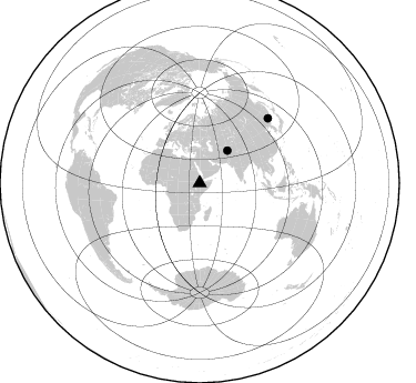
Azimuth Distribution of Events:
Prior Results for this Station
| Study | Thickness | Vp/Vs | Vp | Vs | Poissons Ratio | Extra |
| EARS | 40 km | 1.78 | 6.464 km/s | 3.636 km/s | 0.27 | |
| Crust2.0 | 31 km | 1.76 | 6.464 km/s | 3.663 km/s | 0.26 | G9,thin custal Archean 0.1 km seds., South American |
| Global Maxima | 40 km | 1.78 | 6.464 km/s | 3.636 km/s | 0.27 | amp=0.06578557 |
| Local Maxima 1 | 25 km | 2.05 | 6.464 km/s | 3.153 km/s | 0.34 | amp=0.049741022 |
| Local Maxima 2 | 52 km | 1.60 | 6.464 km/s | 4.04 km/s | 0.18 | amp=0.04529551 |
| Local Maxima 3 | 32 km | 2.02 | 6.464 km/s | 3.208 km/s | 0.34 | amp=0.019170562 |
| Local Maxima 4 | 47 km | 1.69 | 6.464 km/s | 3.836 km/s | 0.23 | amp=0.016846754 |
| Predicted Arrivals for vertical incidence (zero ray parameter) | |
| Ps | 4.75 SECOND |
| PpPs | 16.97 SECOND |
| PsPs/PpSs | 21.73 SECOND |
Events Processed for this Station
Download zip of receiver functions as SAC
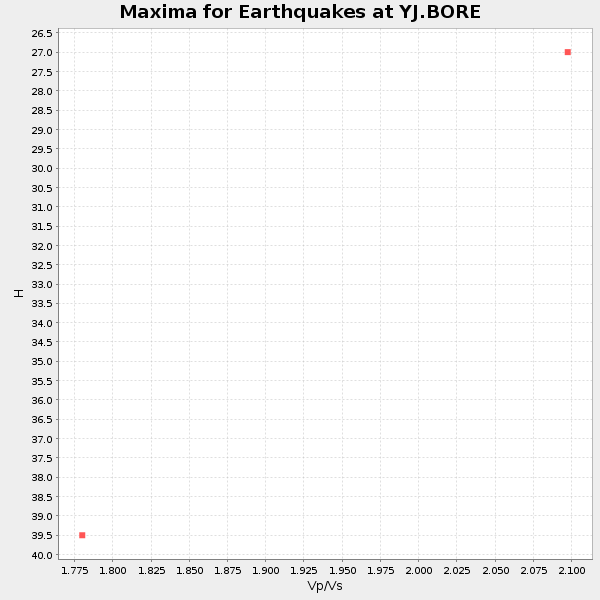
Plot maxima for each earthquake.
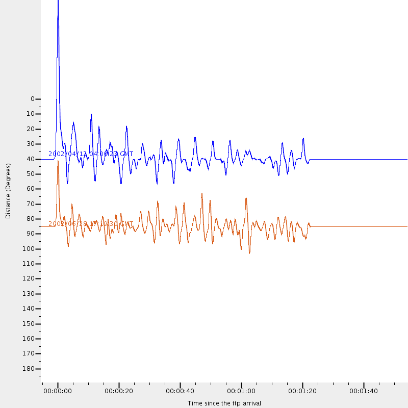
Events Used in the Stack
(2 events)| Radial Match | Distance | Baz | FERegion | Time | Lat/Lon | Depth | Magnitude |
| 89.97688 | 38.4 deg | 40.581 deg | Hindu Kush Region, Afghanistan | 2002/04/12 04:00:23 GMT | (36.0, 69.4) | 10 km | 5.8 MB, 5.9 MS, 5.9 MW, 5.7 MW |
| 86.16407 | 84.8 deg | 46.676 deg | E. Russia-N.E. China Border Reg. | 2002/06/28 17:19:30 GMT | (43.8, 130.7) | 566 km | 6.7 MB, 7.3 MW, 7.3 MW |
Losers
(1 events)| Radial Match | Distance | Baz | FERegion | Time | Lat/Lon | Depth | Magnitude | Reason |
| 49.22229 | 57.7 deg | 90.191 deg | Northern Sumatra, Indonesia | 2003/01/22 02:58:50 GMT | (4.5, 97.6) | 33 km | 5.7 MB |
