
Station YJ DIKE - Diksis Junior School
Network: YJ01 - Ethiopia-Afar Geoscientific Lithospheric Experiment
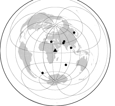
Nearby stations (2 deg radius)
| Station | Name | (Lat, Lon) | Start / End | Elevation |
| DIKE | Diksis Junior School | (8.06, 39.56) | 2001-10-30 / 2003-01-23 | 2.8 km |
| Crust2 Type: | G9,thin custal Archean 0.1 km seds., South American |
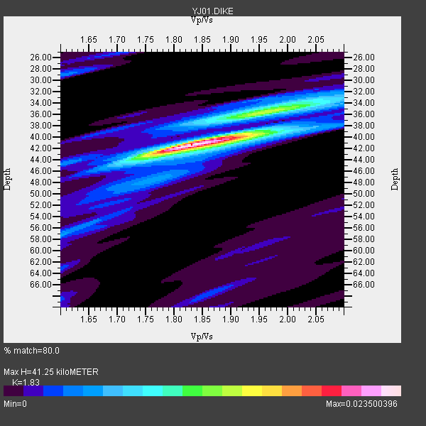
| Thickness Estimate: | 41 km |
| Thickness StdDev: | 4.1 km |
| Vp/Vs Estimate: | 1.83 |
| Vp/Vs StdDev: | 0.06 |
| Vs Estimate: | 3.532 km/s |
| Poisson's Ratio: | 0.29 |
| Peak Value: | 0.02 |
| Assumed Vp: | 6.464 km/s |
| Ps Weight: | 0.33333334 |
| PpPs Weight: | 0.33333334 |
| PsPs Weight: | 0.33333328 |
| Residual Complexity: | 0.436 |
| Nearby stations H: | +- |
| (2.0 deg) Vp/Vs: | +- |
2 with match > 90% ( 28.571428 %) and 7 with match > 80% ( 100.0 %) out of 7.
Download stack as xyz text file.
Azimuth Distribution of Events:
Prior Results for this Station
| Study | Thickness | Vp/Vs | Vp | Vs | Poissons Ratio | Extra |
| EARS | 41 km | 1.83 | 6.464 km/s | 3.532 km/s | 0.29 | |
| Crust2.0 | 31 km | 1.76 | 6.464 km/s | 3.663 km/s | 0.26 | G9,thin custal Archean 0.1 km seds., South American |
| Global Maxima | 41 km | 1.83 | 6.464 km/s | 3.532 km/s | 0.29 | amp=0.023500396 |
| Local Maxima 1 | 35 km | 1.98 | 6.464 km/s | 3.269 km/s | 0.33 | amp=0.010053359 |
| Local Maxima 2 | 40 km | 1.95 | 6.464 km/s | 3.323 km/s | 0.32 | amp=0.004297554 |
| Local Maxima 3 | 29 km | 1.60 | 6.464 km/s | 4.033 km/s | 0.18 | amp=0.00408833 |
| Local Maxima 4 | 44 km | 1.73 | 6.464 km/s | 3.736 km/s | 0.25 | amp=0.0039547924 |
| Predicted Arrivals for vertical incidence (zero ray parameter) | |
| Ps | 5.30 SECOND |
| PpPs | 18.06 SECOND |
| PsPs/PpSs | 23.36 SECOND |
Events Processed for this Station
Download zip of receiver functions as SAC
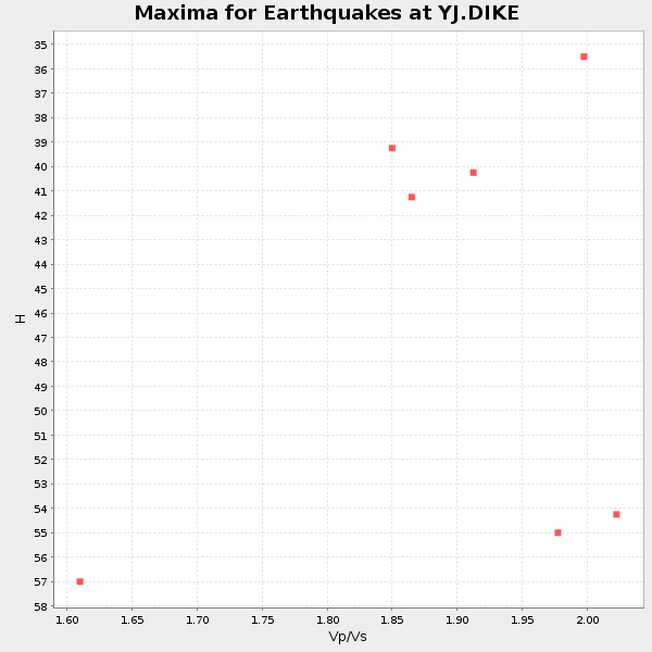
Plot maxima for each earthquake.
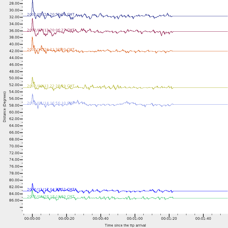
Events Used in the Stack
(7 events)| Radial Match | Distance | Baz | FERegion | Time | Lat/Lon | Depth | Magnitude |
| 92.29113 | 52.8 deg | 79.785 deg | Andaman Islands, India Region | 2002/09/13 22:28:29 GMT | (13.0, 93.1) | 21 km | 6.2 MB, 6.7 MS, 6.5 MW, 6.5 MW |
| 91.491035 | 83.2 deg | 209.837 deg | South Sandwich Islands Region | 2002/12/17 04:32:53 GMT | (-57.0, -24.8) | 10 km | 5.4 MB, 6.3 MS, 6.2 MW, 6.0 MW |
| 89.0892 | 57.7 deg | 142.808 deg | Mid-Indian Ridge | 2002/05/14 16:56:10 GMT | (-36.5, 78.9) | 10 km | 5.6 MB, 6.1 MS, 6.3 MW, 6.1 MW |
| 84.99639 | 36.3 deg | 47.369 deg | Pakistan | 2002/07/13 20:06:27 GMT | (30.8, 70.0) | 33 km | 5.4 MB, 5.7 MS, 5.8 MW, 5.6 MW |
| 84.46976 | 42.0 deg | 44.396 deg | Northwestern Kashmir | 2002/11/20 21:32:30 GMT | (35.4, 74.5) | 33 km | 5.7 MB, 6.5 MS, 6.4 MW, 6.0 MW |
| 81.569885 | 85.3 deg | 46.633 deg | E. Russia-N.E. China Border Reg. | 2002/06/28 17:19:30 GMT | (43.8, 130.7) | 566 km | 6.7 MB, 7.3 MW, 7.3 MW |
| 80.32972 | 31.7 deg | 336.171 deg | Southern Greece | 2002/05/21 20:53:29 GMT | (36.6, 24.3) | 97 km | 5.4 MB, 5.6 MD |
Losers
(0 events)| Radial Match | Distance | Baz | FERegion | Time | Lat/Lon | Depth | Magnitude | Reason |
