
Station YJ GEWE - Gewane Agricultural College
Network: YJ01 - Ethiopia-Afar Geoscientific Lithospheric Experiment
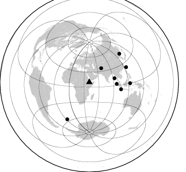
Nearby stations (2 deg radius)
| Station | Name | (Lat, Lon) | Start / End | Elevation |
| GEWE | Gewane Agricultural College | (10.01, 40.57) | 2001-11-20 / 2002-12-10 | 600 m |
| Crust2 Type: | X4,very thin Afar Rift 0.75 km sediments |
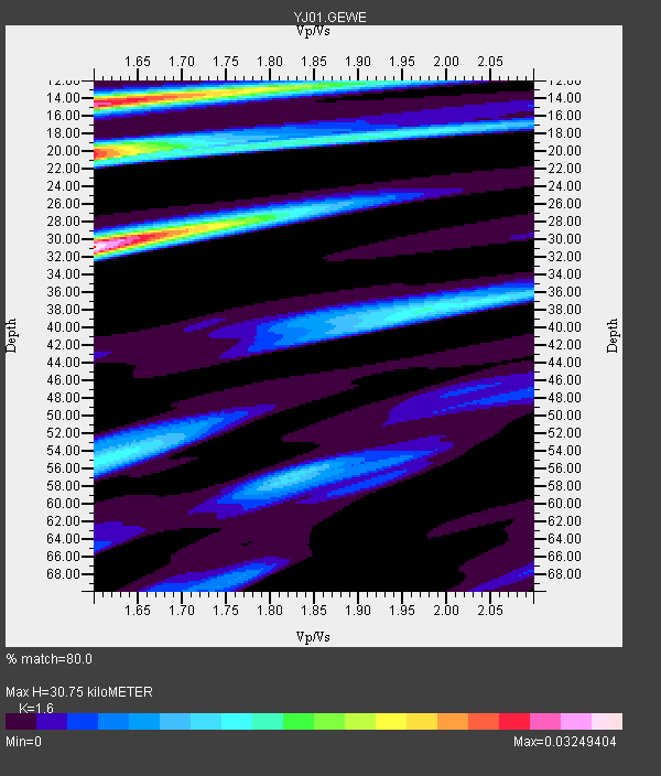
| Thickness Estimate: | 31 km |
| Thickness StdDev: | 10 km |
| Vp/Vs Estimate: | 1.60 |
| Vp/Vs StdDev: | 0.05 |
| Vs Estimate: | 3.984 km/s |
| Poisson's Ratio: | 0.18 |
| Peak Value: | 0.03 |
| Assumed Vp: | 6.375 km/s |
| Ps Weight: | 0.33333334 |
| PpPs Weight: | 0.33333334 |
| PsPs Weight: | 0.33333328 |
| Residual Complexity: | 0.839 |
| Nearby stations H: | +- |
| (2.0 deg) Vp/Vs: | +- |
5 with match > 90% ( 62.5 %) and 8 with match > 80% ( 100.0 %) out of 8.
Download stack as xyz text file.
Azimuth Distribution of Events:
Prior Results for this Station
| Study | Thickness | Vp/Vs | Vp | Vs | Poissons Ratio | Extra |
| EARS | 31 km | 1.60 | 6.375 km/s | 3.984 km/s | 0.18 | |
| Crust2.0 | 17 km | 1.77 | 6.375 km/s | 3.604 km/s | 0.27 | X4,very thin Afar Rift 0.75 km sediments |
| Global Maxima | 31 km | 1.60 | 6.375 km/s | 3.984 km/s | 0.18 | amp=0.03249404 |
| Local Maxima 1 | 14 km | 1.60 | 6.375 km/s | 3.984 km/s | 0.18 | amp=0.02872734 |
| Local Maxima 2 | 20 km | 1.60 | 6.375 km/s | 3.984 km/s | 0.18 | amp=0.026387436 |
| Local Maxima 3 | 55 km | 1.60 | 6.375 km/s | 3.978 km/s | 0.18 | amp=0.012171506 |
| Local Maxima 4 | 38 km | 1.98 | 6.375 km/s | 3.22 km/s | 0.33 | amp=0.012100534 |
| Predicted Arrivals for vertical incidence (zero ray parameter) | |
| Ps | 2.89 SECOND |
| PpPs | 12.54 SECOND |
| PsPs/PpSs | 15.44 SECOND |
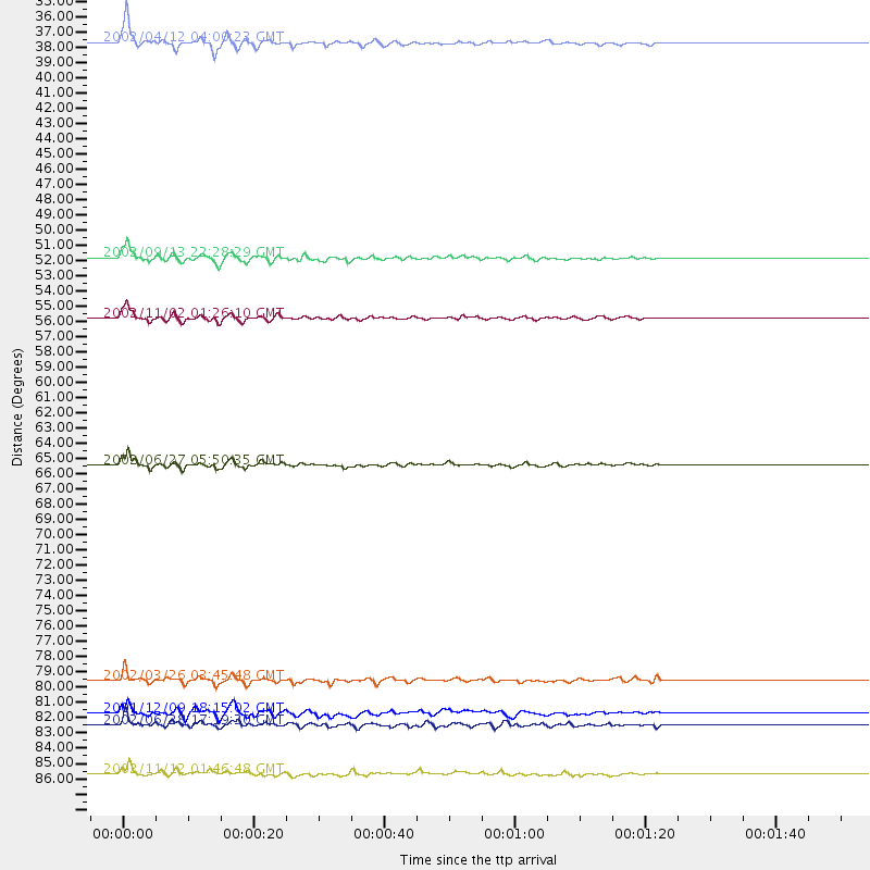
Events Processed for this Station
Download zip of receiver functions as SAC
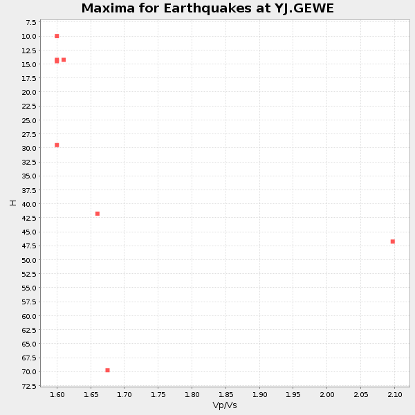
Plot maxima for each earthquake.
Events Used in the Stack
(8 events)| Radial Match | Distance | Baz | FERegion | Time | Lat/Lon | Depth | Magnitude |
| 94.947914 | 51.5 deg | 81.297 deg | Andaman Islands, India Region | 2002/09/13 22:28:29 GMT | (13.0, 93.1) | 21 km | 6.2 MB, 6.7 MS, 6.5 MW, 6.5 MW |
| 94.005104 | 55.6 deg | 93.436 deg | Northern Sumatra, Indonesia | 2002/11/02 01:26:10 GMT | (2.8, 96.1) | 30 km | 6.2 MB, 7.6 MS, 7.4 MW, 7.4 MW |
| 93.291245 | 36.8 deg | 40.816 deg | Hindu Kush Region, Afghanistan | 2002/04/12 04:00:23 GMT | (36.0, 69.4) | 10 km | 5.8 MB, 5.9 MS, 5.9 MW, 5.7 MW |
| 92.32897 | 83.2 deg | 46.864 deg | E. Russia-N.E. China Border Reg. | 2002/06/28 17:19:30 GMT | (43.8, 130.7) | 566 km | 6.7 MB, 7.3 MW, 7.3 MW |
| 91.115265 | 65.6 deg | 102.356 deg | Sunda Strait, Indonesia | 2002/06/27 05:50:35 GMT | (-7.0, 104.2) | 11 km | 6.0 MB, 6.9 MS, 6.6 MW, 6.5 MW |
| 88.09333 | 82.4 deg | 91.34 deg | Minahassa Peninsula, Sulawesi | 2001/12/09 18:15:02 GMT | (-0.0, 122.9) | 156 km | 5.7 MB, 6.2 MW, 6.0 MW |
| 87.00276 | 80.2 deg | 67.933 deg | Southwestern Ryukyu Isl., Japan | 2002/03/26 03:45:48 GMT | (23.3, 124.1) | 33 km | 5.8 MB, 6.6 MS, 6.4 MW, 6.4 MW |
| 80.99609 | 86.6 deg | 210.983 deg | South Sandwich Islands Region | 2002/11/12 01:46:48 GMT | (-56.5, -27.5) | 120 km | 6.0 MB, 6.3 MW, 6.2 MW |
Losers
(0 events)| Radial Match | Distance | Baz | FERegion | Time | Lat/Lon | Depth | Magnitude | Reason |
