
Station YJ KARE - Kara Kore Kunior School
Network: YJ01 - Ethiopia-Afar Geoscientific Lithospheric Experiment
Nearby stations (2 deg radius)
| Station | Name | (Lat, Lon) | Start / End | Elevation |
| KARE | Kara Kore Kunior School | (10.42, 39.93) | 2002-04-30 / 2003-01-28 | 1774 m |
| Crust2 Type: | X2,Rift, Rio Grande, Baikal, 0.5km sediments |
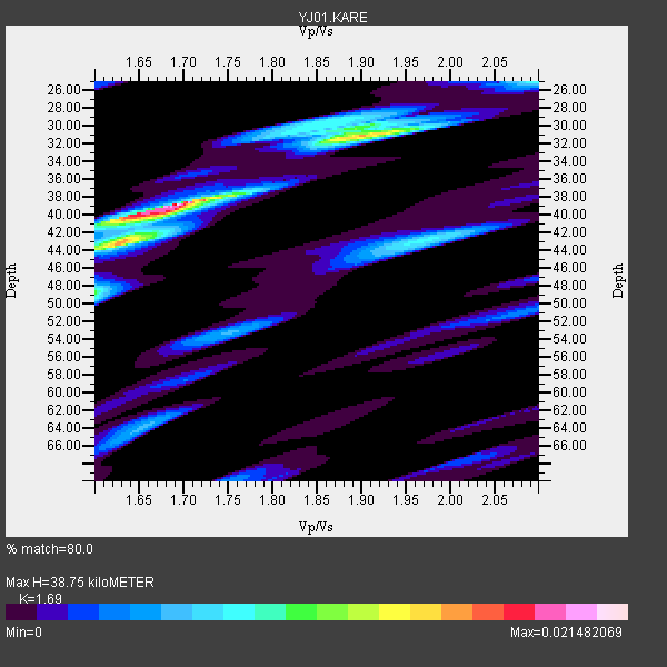
| Thickness Estimate: | 39 km |
| Thickness StdDev: | 8.2 km |
| Vp/Vs Estimate: | 1.69 |
| Vp/Vs StdDev: | 0.14 |
| Vs Estimate: | 3.847 km/s |
| Poisson's Ratio: | 0.23 |
| Peak Value: | 0.02 |
| Assumed Vp: | 6.502 km/s |
| Ps Weight: | 0.33333334 |
| PpPs Weight: | 0.33333334 |
| PsPs Weight: | 0.33333328 |
| Residual Complexity: | 0.701 |
| Nearby stations H: | 42 km +- 4.9 km |
| (2.0 deg) Vp/Vs: | 1.77 +- 0.11 |
1 with match > 90% ( 16.666666 %) and 4 with match > 80% ( 66.666664 %) out of 6.
Download stack as xyz text file.
Azimuth Distribution of Events:

Prior Results for this Station
| Study | Thickness | Vp/Vs | Vp | Vs | Poissons Ratio | Extra |
| EARS | 39 km | 1.69 | 6.502 km/s | 3.847 km/s | 0.23 | |
| Crust2.0 | 33 km | 1.77 | 6.502 km/s | 3.68 km/s | 0.26 | X2,Rift, Rio Grande, Baikal, 0.5km sediments |
| Global Maxima | 39 km | 1.69 | 6.502 km/s | 3.847 km/s | 0.23 | amp=0.021482069 |
| Local Maxima 1 | 31 km | 1.90 | 6.502 km/s | 3.422 km/s | 0.31 | amp=0.014710903 |
| Local Maxima 2 | 43 km | 1.62 | 6.502 km/s | 4.001 km/s | 0.20 | amp=0.01131106 |
| Local Maxima 3 | 43 km | 1.97 | 6.502 km/s | 3.3 km/s | 0.33 | amp=0.007924435 |
| Local Maxima 4 | 30 km | 1.85 | 6.502 km/s | 3.51 km/s | 0.29 | amp=0.0063994243 |
| Predicted Arrivals for vertical incidence (zero ray parameter) | |
| Ps | 4.11 SECOND |
| PpPs | 16.03 SECOND |
| PsPs/PpSs | 20.15 SECOND |
Events Processed for this Station
Download zip of receiver functions as SAC
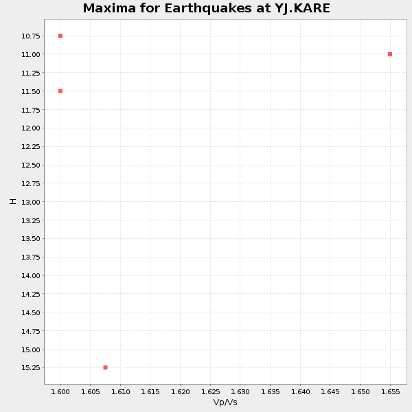
Plot maxima for each earthquake.
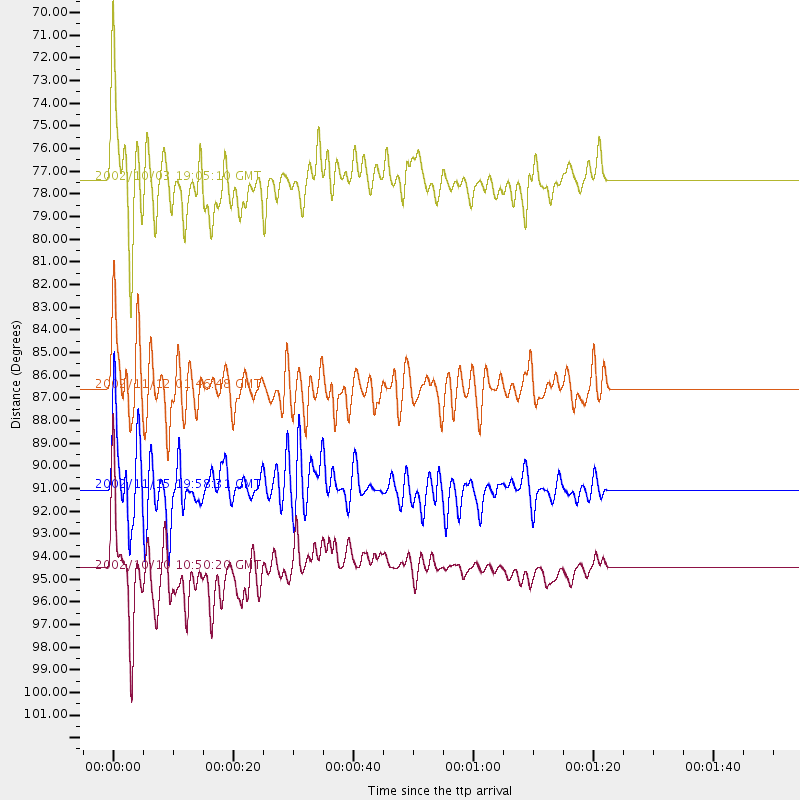
Events Used in the Stack
(4 events)| Radial Match | Distance | Baz | FERegion | Time | Lat/Lon | Depth | Magnitude |
| 90.12251 | 94.6 deg | 90.937 deg | Irian Jaya Region, Indonesia | 2002/10/10 10:50:20 GMT | (-1.8, 134.3) | 10 km | 6.5 MB, 7.7 MS, 7.6 MW, 7.4 MW |
| 88.661766 | 86.6 deg | 210.825 deg | South Sandwich Islands Region | 2002/11/12 01:46:48 GMT | (-56.5, -27.5) | 120 km | 6.0 MB, 6.3 MW, 6.2 MW |
| 88.3197 | 77.5 deg | 100.144 deg | Bali Sea | 2002/10/03 19:05:10 GMT | (-7.5, 115.7) | 316 km | 6.0 MB, 6.0 MW, 6.0 MW |
| 87.954414 | 91.1 deg | 213.042 deg | South Georgia Island Region | 2002/11/15 19:58:31 GMT | (-56.1, -36.4) | 10 km | 6.1 MB, 6.6 MS, 6.7 MW, 6.4 MW |
Losers
(2 events)| Radial Match | Distance | Baz | FERegion | Time | Lat/Lon | Depth | Magnitude | Reason |
| 66.46056 | 95.8 deg | 92.806 deg | Irian Jaya Region, Indonesia | 2002/12/11 03:49:40 GMT | (-3.8, 135.1) | 10 km | 5.8 MB, 6.0 MS, 6.3 MW, 6.3 MW | |
| 53.949467 | 68.5 deg | 143.199 deg | Southeast Indian Ridge | 2002/10/08 01:23:58 GMT | (-42.0, 88.4) | 10 km | 5.3 MB, 5.7 MS, 6.0 MW, 5.9 MW |
