
Station YJ MIEE - Mieso Junior School
Network: YJ01 - Ethiopia-Afar Geoscientific Lithospheric Experiment
Nearby stations (2 deg radius)
| Station | Name | (Lat, Lon) | Start / End | Elevation |
| MIEE | Mieso Junior School | (9.24, 40.76) | 2001-10-31 / 2003-01-23 | 1349 m |
| Crust2 Type: | IG,very thin late Proter., no seds. |
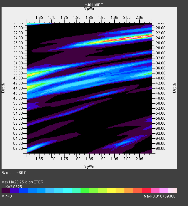
| Thickness Estimate: | 23 km |
| Thickness StdDev: | 9.7 km |
| Vp/Vs Estimate: | 2.06 |
| Vp/Vs StdDev: | 0.20 |
| Vs Estimate: | 3.221 km/s |
| Poisson's Ratio: | 0.35 |
| Peak Value: | 0.02 |
| Assumed Vp: | 6.643 km/s |
| Ps Weight: | 0.33333334 |
| PpPs Weight: | 0.33333334 |
| PsPs Weight: | 0.33333328 |
| Residual Complexity: | 0.763 |
| Nearby stations H: | +- |
| (2.0 deg) Vp/Vs: | +- |
3 with match > 90% ( 25.0 %) and 11 with match > 80% ( 91.666664 %) out of 12.
Download stack as xyz text file.
Azimuth Distribution of Events:

Prior Results for this Station
| Study | Thickness | Vp/Vs | Vp | Vs | Poissons Ratio | Extra |
| EARS | 23 km | 2.06 | 6.643 km/s | 3.221 km/s | 0.35 | |
| Crust2.0 | 23 km | 1.77 | 6.643 km/s | 3.757 km/s | 0.26 | IG,very thin late Proter., no seds. |
| Global Maxima | 23 km | 2.06 | 6.643 km/s | 3.221 km/s | 0.35 | amp=0.016759308 |
| Local Maxima 1 | 44 km | 1.60 | 6.643 km/s | 4.152 km/s | 0.18 | amp=0.01007966 |
| Local Maxima 2 | 39 km | 1.60 | 6.643 km/s | 4.152 km/s | 0.18 | amp=0.009924211 |
| Local Maxima 3 | 38 km | 2.10 | 6.643 km/s | 3.167 km/s | 0.35 | amp=0.009031518 |
| Local Maxima 4 | 38 km | 1.82 | 6.643 km/s | 3.655 km/s | 0.28 | amp=0.0072250133 |
| Predicted Arrivals for vertical incidence (zero ray parameter) | |
| Ps | 3.72 SECOND |
| PpPs | 10.72 SECOND |
| PsPs/PpSs | 14.44 SECOND |
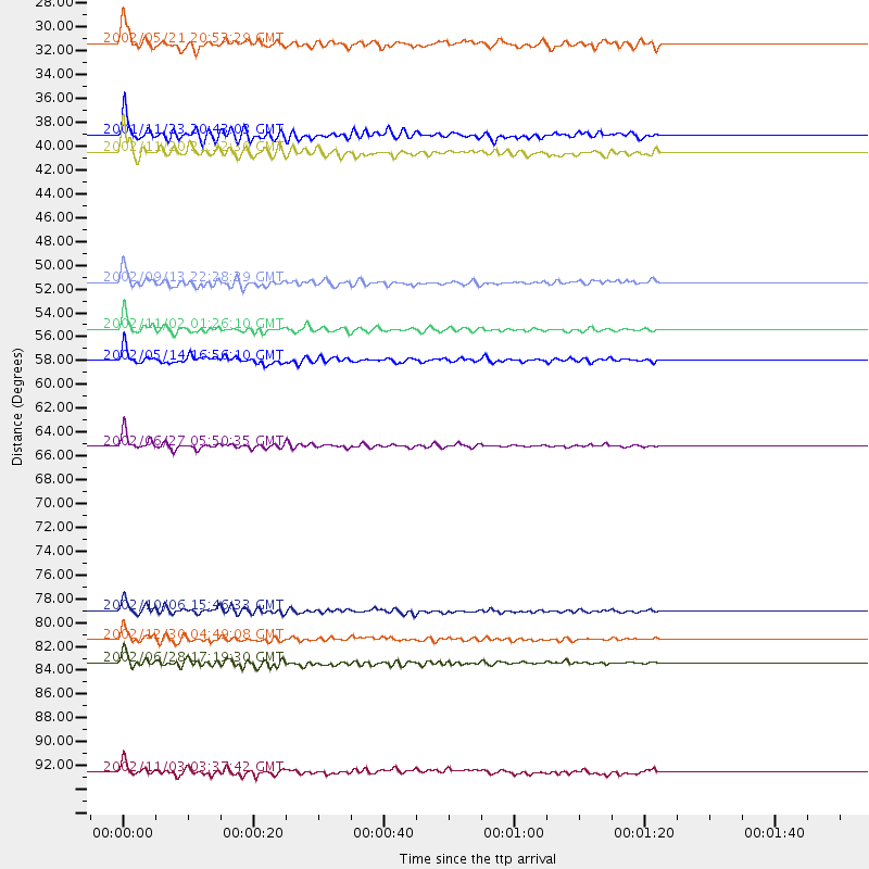
Events Processed for this Station
Download zip of receiver functions as SAC
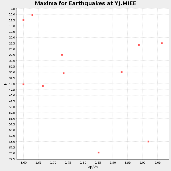
Plot maxima for each earthquake.
Events Used in the Stack
(11 events)| Radial Match | Distance | Baz | FERegion | Time | Lat/Lon | Depth | Magnitude |
| 95.704094 | 65.2 deg | 102.064 deg | Sunda Strait, Indonesia | 2002/06/27 05:50:35 GMT | (-7.0, 104.2) | 11 km | 6.0 MB, 6.9 MS, 6.6 MW, 6.5 MW |
| 94.33048 | 55.3 deg | 92.951 deg | Northern Sumatra, Indonesia | 2002/11/02 01:26:10 GMT | (2.8, 96.1) | 30 km | 6.2 MB, 7.6 MS, 7.4 MW, 7.4 MW |
| 90.58121 | 83.6 deg | 46.817 deg | E. Russia-N.E. China Border Reg. | 2002/06/28 17:19:30 GMT | (43.8, 130.7) | 566 km | 6.7 MB, 7.3 MW, 7.3 MW |
| 89.655426 | 38.8 deg | 41.122 deg | Afghanistan-Tajikistan Bord Reg. | 2001/11/23 20:43:03 GMT | (36.4, 71.5) | 106 km | 5.9 MB, 6.1 MW, 6.0 MW |
| 88.82894 | 51.4 deg | 80.707 deg | Andaman Islands, India Region | 2002/09/13 22:28:29 GMT | (13.0, 93.1) | 21 km | 6.2 MB, 6.7 MS, 6.5 MW, 6.5 MW |
| 87.60075 | 58.0 deg | 144.026 deg | Mid-Indian Ridge | 2002/05/14 16:56:10 GMT | (-36.5, 78.9) | 10 km | 5.6 MB, 6.1 MS, 6.3 MW, 6.1 MW |
| 86.68942 | 40.3 deg | 44.545 deg | Northwestern Kashmir | 2002/11/20 21:32:30 GMT | (35.4, 74.5) | 33 km | 5.7 MB, 6.5 MS, 6.4 MW, 6.0 MW |
| 85.73992 | 81.6 deg | 83.775 deg | Mindanao, Philippines | 2002/12/30 04:49:08 GMT | (7.5, 123.4) | 10 km | 5.9 MB, 6.2 MS, 6.3 MW, 6.2 MW |
| 81.73688 | 31.1 deg | 333.773 deg | Southern Greece | 2002/05/21 20:53:29 GMT | (36.6, 24.3) | 97 km | 5.4 MB, 5.6 MD |
| 81.49465 | 79.2 deg | 100.191 deg | Sumbawa Region, Indonesia | 2002/10/06 15:46:33 GMT | (-8.2, 118.3) | 10 km | 5.8 MB, 6.0 MS, 6.2 MW, 6.2 MW |
| 80.550995 | 92.9 deg | 50.041 deg | Near East Coast Of Honshu, Japan | 2002/11/03 03:37:42 GMT | (38.9, 142.0) | 39 km | 5.7 MB, 6.1 MS, 6.4 MW, 6.4 MW |
Losers
(1 events)| Radial Match | Distance | Baz | FERegion | Time | Lat/Lon | Depth | Magnitude | Reason |
| 79.32492 | 90.1 deg | 213.388 deg | South Georgia Island Region | 2002/11/15 13:05:36 GMT | (-55.7, -35.8) | 10 km | 5.8 MB, 5.5 MS, 5.8 MW, 5.8 MW |
