
Station YJ SENE - Sendafa High School
Network: YJ01 - Ethiopia-Afar Geoscientific Lithospheric Experiment
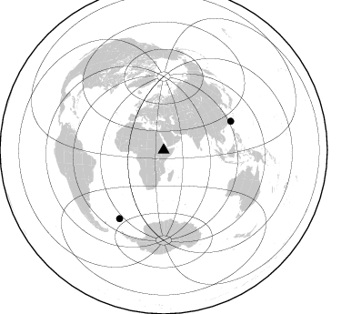
Nearby stations (2 deg radius)
| Station | Name | (Lat, Lon) | Start / End | Elevation |
| SENE | Sendafa High School | (9.15, 39.02) | 2001-10-26 / 2003-01-18 | 2.6 km |
| Crust2 Type: | G9,thin custal Archean 0.1 km seds., South American |
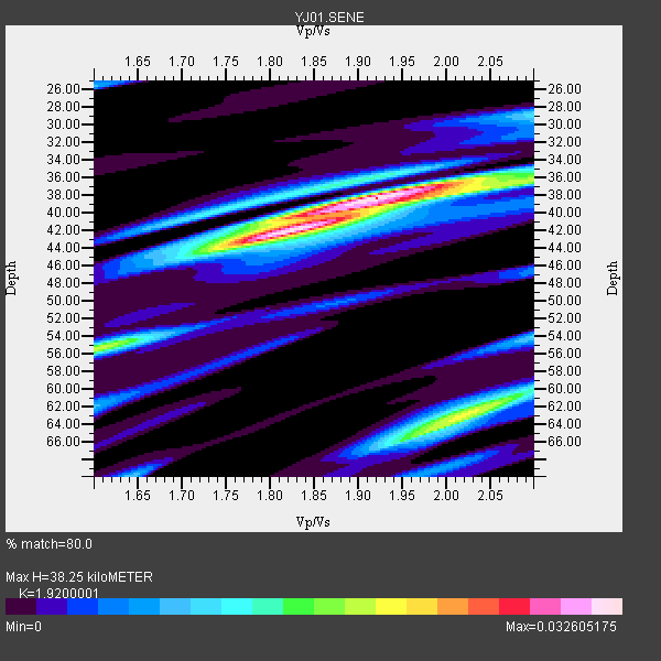
| Thickness Estimate: | 38 km |
| Thickness StdDev: | 1.8 km |
| Vp/Vs Estimate: | 1.92 |
| Vp/Vs StdDev: | 0.17 |
| Vs Estimate: | 3.366 km/s |
| Poisson's Ratio: | 0.31 |
| Peak Value: | 0.03 |
| Assumed Vp: | 6.464 km/s |
| Ps Weight: | 0.33333334 |
| PpPs Weight: | 0.33333334 |
| PsPs Weight: | 0.33333328 |
| Residual Complexity: | 0.671 |
| Nearby stations H: | +- |
| (2.0 deg) Vp/Vs: | +- |
1 with match > 90% ( 50.0 %) and 2 with match > 80% ( 100.0 %) out of 2.
Download stack as xyz text file.
Azimuth Distribution of Events:
Prior Results for this Station
| Study | Thickness | Vp/Vs | Vp | Vs | Poissons Ratio | Extra |
| EARS | 38 km | 1.92 | 6.464 km/s | 3.366 km/s | 0.31 | |
| Crust2.0 | 31 km | 1.76 | 6.464 km/s | 3.663 km/s | 0.26 | G9,thin custal Archean 0.1 km seds., South American |
| Global Maxima | 38 km | 1.92 | 6.464 km/s | 3.366 km/s | 0.31 | amp=0.032605175 |
| Local Maxima 1 | 42 km | 1.81 | 6.464 km/s | 3.576 km/s | 0.28 | amp=0.02856469 |
| Local Maxima 2 | 63 km | 2.02 | 6.464 km/s | 3.196 km/s | 0.34 | amp=0.019932926 |
| Local Maxima 3 | 55 km | 1.61 | 6.464 km/s | 4.027 km/s | 0.18 | amp=0.017670041 |
| Local Maxima 4 | 65 km | 1.96 | 6.464 km/s | 3.294 km/s | 0.32 | amp=0.012635614 |
| Predicted Arrivals for vertical incidence (zero ray parameter) | |
| Ps | 5.44 SECOND |
| PpPs | 17.28 SECOND |
| PsPs/PpSs | 22.72 SECOND |
Events Processed for this Station
Download zip of receiver functions as SAC
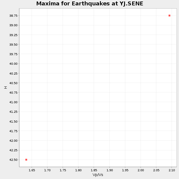
Plot maxima for each earthquake.
Events Used in the Stack
(2 events)| Radial Match | Distance | Baz | FERegion | Time | Lat/Lon | Depth | Magnitude |
| 91.792786 | 80.1 deg | 66.894 deg | Taiwan Region | 2002/03/31 06:52:50 GMT | (24.3, 122.2) | 33 km | 6.4 MB, 7.4 MS, 7.1 MW, 7.1 MW |
| 85.68553 | 89.5 deg | 212.888 deg | South Georgia Island Region | 2002/11/15 19:58:31 GMT | (-56.1, -36.4) | 10 km | 6.1 MB, 6.6 MS, 6.7 MW, 6.4 MW |
Losers
(0 events)| Radial Match | Distance | Baz | FERegion | Time | Lat/Lon | Depth | Magnitude | Reason |
