
Station YJ SHEE - Shewa Robit High school
Network: YJ01 - Ethiopia-Afar Geoscientific Lithospheric Experiment
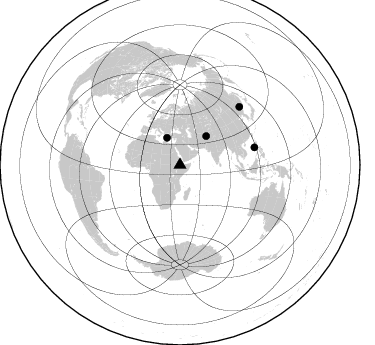
Nearby stations (2 deg radius)
| Station | Name | (Lat, Lon) | Start / End | Elevation |
| SHEE | Shewa Robit High school | (10.00, 39.89) | 2001-10-25 / 2003-01-28 | 1298 m |
| Crust2 Type: | G9,thin custal Archean 0.1 km seds., South American |
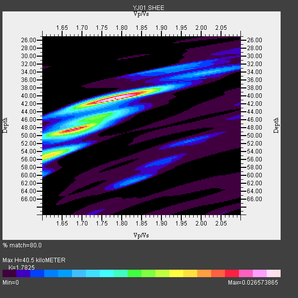
| Thickness Estimate: | 40 km |
| Thickness StdDev: | 7.4 km |
| Vp/Vs Estimate: | 1.78 |
| Vp/Vs StdDev: | 0.14 |
| Vs Estimate: | 3.626 km/s |
| Poisson's Ratio: | 0.27 |
| Peak Value: | 0.03 |
| Assumed Vp: | 6.464 km/s |
| Ps Weight: | 0.33333334 |
| PpPs Weight: | 0.33333334 |
| PsPs Weight: | 0.33333328 |
| Residual Complexity: | 0.613 |
| Nearby stations H: | +- |
| (2.0 deg) Vp/Vs: | +- |
1 with match > 90% ( 20.0 %) and 4 with match > 80% ( 80.0 %) out of 5.
Download stack as xyz text file.
Azimuth Distribution of Events:
Prior Results for this Station
| Study | Thickness | Vp/Vs | Vp | Vs | Poissons Ratio | Extra |
| EARS | 40 km | 1.78 | 6.464 km/s | 3.626 km/s | 0.27 | |
| Crust2.0 | 31 km | 1.76 | 6.464 km/s | 3.663 km/s | 0.26 | G9,thin custal Archean 0.1 km seds., South American |
| Global Maxima | 40 km | 1.78 | 6.464 km/s | 3.626 km/s | 0.27 | amp=0.026573865 |
| Local Maxima 1 | 55 km | 1.62 | 6.464 km/s | 3.996 km/s | 0.19 | amp=0.01828419 |
| Local Maxima 2 | 48 km | 1.69 | 6.464 km/s | 3.825 km/s | 0.23 | amp=0.015577458 |
| Local Maxima 3 | 45 km | 1.76 | 6.464 km/s | 3.672 km/s | 0.26 | amp=0.007990592 |
| Local Maxima 4 | 61 km | 1.83 | 6.464 km/s | 3.532 km/s | 0.29 | amp=0.0055506444 |
| Predicted Arrivals for vertical incidence (zero ray parameter) | |
| Ps | 4.90 SECOND |
| PpPs | 17.43 SECOND |
| PsPs/PpSs | 22.34 SECOND |
Events Processed for this Station
Download zip of receiver functions as SAC
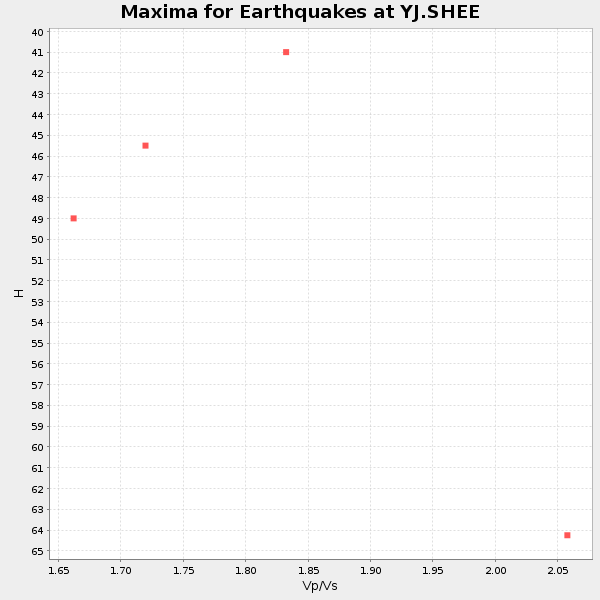
Plot maxima for each earthquake.
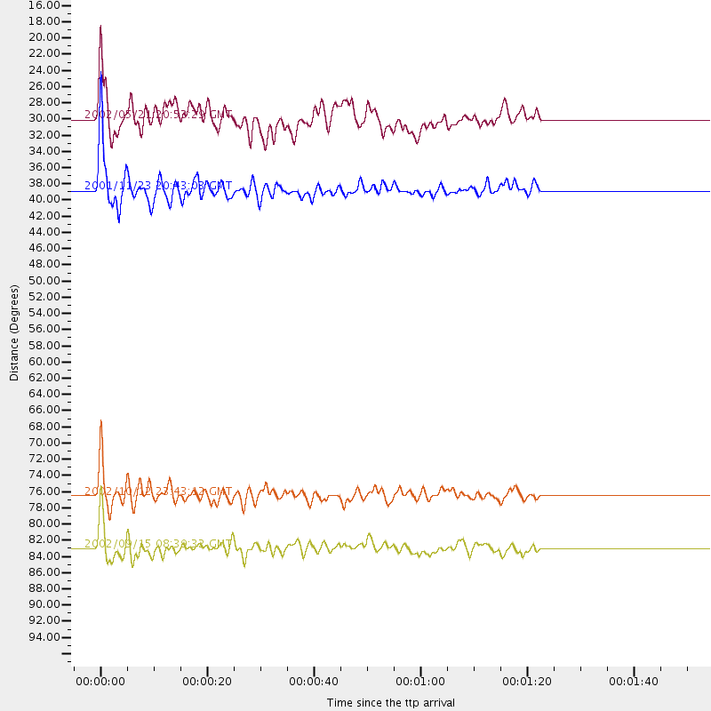
Events Used in the Stack
(4 events)| Radial Match | Distance | Baz | FERegion | Time | Lat/Lon | Depth | Magnitude |
| 90.6759 | 38.9 deg | 42.39 deg | Afghanistan-Tajikistan Bord Reg. | 2001/11/23 20:43:03 GMT | (36.4, 71.5) | 106 km | 5.9 MB, 6.1 MW, 6.0 MW |
| 87.1004 | 76.6 deg | 76.804 deg | Philippine Islands Region | 2002/10/12 23:43:12 GMT | (15.1, 118.5) | 33 km | 5.6 MB, 5.6 MS, 6.1 MW |
| 80.819725 | 30.0 deg | 334.368 deg | Southern Greece | 2002/05/21 20:53:29 GMT | (36.6, 24.3) | 97 km | 5.4 MB, 5.6 MD |
| 80.08871 | 83.1 deg | 45.79 deg | Northeastern China | 2002/09/15 08:39:32 GMT | (44.8, 129.9) | 586 km | 5.8 MB, 6.4 MW, 6.4 MW |
Losers
(1 events)| Radial Match | Distance | Baz | FERegion | Time | Lat/Lon | Depth | Magnitude | Reason |
| 60.550697 | 78.7 deg | 72.399 deg | Philippine Islands Region | 2002/05/13 19:54:43 GMT | (19.1, 121.2) | 33 km | 5.5 MW, 5.4 MB |
