
Station YL HILE - YL.HILE
Network: YL01 - Himalayan Nepal Tibet Experiment
Nearby stations (2 deg radius)
| Station | Name | (Lat, Lon) | Start / End | Elevation |
| HILE | YL.HILE | (27.05, 87.32) | 2001-09-07 / 2003-01-01 | 2088 m |
| Crust2 Type: | P7,orogen/50km, Urals, Tethian Orogen, 3 km seds. |
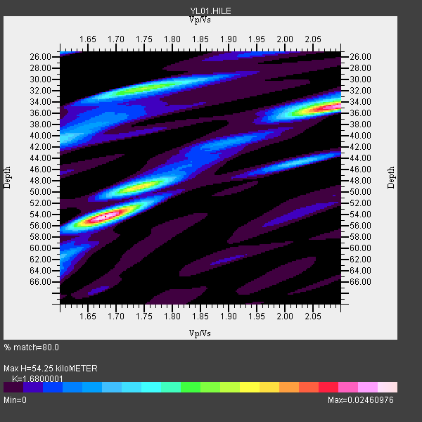
| Thickness Estimate: | 54 km |
| Thickness StdDev: | 9.6 km |
| Vp/Vs Estimate: | 1.68 |
| Vp/Vs StdDev: | 0.19 |
| Vs Estimate: | 3.712 km/s |
| Poisson's Ratio: | 0.23 |
| Peak Value: | 0.02 |
| Assumed Vp: | 6.236 km/s |
| Ps Weight: | 0.33333334 |
| PpPs Weight: | 0.33333334 |
| PsPs Weight: | 0.33333328 |
| Residual Complexity: | 0.724 |
| Nearby stations H: | +- |
| (2.0 deg) Vp/Vs: | +- |
15 with match > 90% ( 34.090908 %) and 31 with match > 80% ( 70.454544 %) out of 44.
Download stack as xyz text file.
Azimuth Distribution of Events:

Prior Results for this Station
| Study | Thickness | Vp/Vs | Vp | Vs | Poissons Ratio | Extra |
| EARS | 54 km | 1.68 | 6.236 km/s | 3.712 km/s | 0.23 | |
| Crust2.0 | 53 km | 1.76 | 6.236 km/s | 3.536 km/s | 0.26 | P7,orogen/50km, Urals, Tethian Orogen, 3 km seds. |
| Global Maxima | 54 km | 1.68 | 6.236 km/s | 3.712 km/s | 0.23 | amp=0.02460976 |
| Local Maxima 1 | 34 km | 2.10 | 6.236 km/s | 2.973 km/s | 0.35 | amp=0.022549132 |
| Local Maxima 2 | 32 km | 1.75 | 6.236 km/s | 3.563 km/s | 0.26 | amp=0.013712556 |
| Local Maxima 3 | 49 km | 1.74 | 6.236 km/s | 3.584 km/s | 0.25 | amp=0.012076229 |
| Local Maxima 4 | 40 km | 1.61 | 6.236 km/s | 3.885 km/s | 0.18 | amp=0.006044855 |
| Predicted Arrivals for vertical incidence (zero ray parameter) | |
| Ps | 5.92 SECOND |
| PpPs | 23.32 SECOND |
| PsPs/PpSs | 29.23 SECOND |
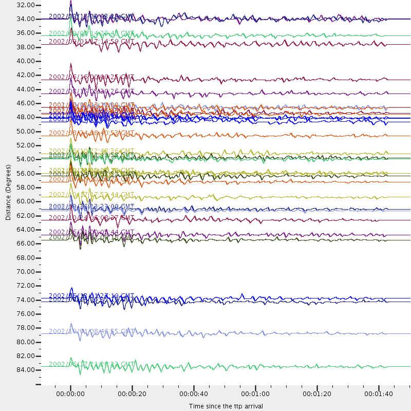
Events Processed for this Station
Download zip of receiver functions as SAC
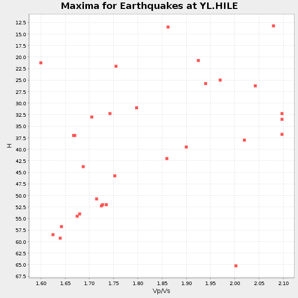
Plot maxima for each earthquake.
Events Used in the Stack
(31 events)| Radial Match | Distance | Baz | FERegion | Time | Lat/Lon | Depth | Magnitude |
| 97.40531 | 61.5 deg | 110.375 deg | Near N Coast Of New Guinea, P.N.G. | 2002/09/08 18:44:23 GMT | (-3.3, 142.9) | 13 km | 6.5 MB, 7.8 MS, 7.6 MW, 7.3 MW |
| 95.91709 | 66.1 deg | 109.345 deg | Eastern New Guinea Reg., P.N.G. | 2002/07/03 23:00:18 GMT | (-5.0, 147.3) | 31 km | 5.6 MB, 6.2 MS, 6.2 MW, 6.2 MW |
| 94.25138 | 47.0 deg | 125.604 deg | Banda Sea | 2001/10/19 03:28:44 GMT | (-4.1, 123.9) | 33 km | 6.3 MB, 7.3 MS, 7.5 MW, 7.4 MW |
| 93.947395 | 49.7 deg | 55.178 deg | Kuril Islands | 2002/08/24 18:40:53 GMT | (43.1, 146.1) | 43 km | 5.9 MB, 5.8 MS, 6.2 MW, 6.1 MW |
| 93.8451 | 43.1 deg | 125.124 deg | Sulawesi, Indonesia | 2002/08/15 05:30:26 GMT | (-1.2, 121.3) | 10 km | 5.7 MB, 5.8 MS, 6.2 MW, 6.1 MW |
| 93.41325 | 53.4 deg | 114.641 deg | Irian Jaya Region, Indonesia | 2002/09/20 15:43:35 GMT | (-1.7, 134.2) | 10 km | 5.9 MB, 6.4 MS, 6.4 MW, 6.3 MW |
| 93.009 | 61.3 deg | 110.551 deg | Near N Coast Of New Guinea, P.N.G. | 2002/09/16 13:23:00 GMT | (-3.3, 142.7) | 10 km | 5.9 MB, 5.9 MS, 6.3 MW, 6.1 MW |
| 92.6956 | 46.9 deg | 57.824 deg | Hokkaido, Japan Region | 2002/10/14 14:12:43 GMT | (41.2, 142.2) | 61 km | 5.9 MB, 6.1 MW, 6.1 MW |
| 92.554245 | 57.0 deg | 43.878 deg | Near East Coast Of Kamchatka | 2002/10/16 10:12:21 GMT | (52.0, 157.3) | 102 km | 6.1 MB, 6.2 MW, 6.2 MW |
| 92.431274 | 59.4 deg | 112.386 deg | Irian Jaya, Indonesia | 2002/10/17 17:52:44 GMT | (-3.6, 140.2) | 33 km | 5.6 MB, 6.2 MS, 6.3 MW, 6.3 MW |
| 92.38848 | 63.0 deg | 252.6 deg | Lake Tanganyika Region | 2002/10/24 06:08:37 GMT | (-1.9, 29.0) | 11 km | 5.9 MB, 6.3 MS, 6.2 MW, 6.1 MW |
| 91.91926 | 55.6 deg | 92.885 deg | South Of Mariana Islands | 2001/10/12 15:02:16 GMT | (12.7, 145.0) | 37 km | 6.7 MB, 7.3 MS, 7.0 MW, 6.9 MW |
| 91.23939 | 40.9 deg | 124.749 deg | Minahassa Peninsula, Sulawesi | 2002/06/16 00:00:25 GMT | (0.5, 119.9) | 35 km | 5.7 MB, 5.5 MS, 5.9 MW, 5.8 MW |
| 91.17617 | 45.3 deg | 118.578 deg | Northern Molucca Sea | 2001/10/13 16:27:00 GMT | (0.8, 126.0) | 33 km | 5.6 MB, 5.7 MS, 6.0 MW, 5.8 MW |
| 90.23706 | 75.3 deg | 171.375 deg | Southeast Indian Ridge | 2002/06/13 01:27:19 GMT | (-47.8, 99.8) | 10 km | 5.5 MB, 6.6 MS, 6.6 MW, 6.5 MW |
| 89.34442 | 65.4 deg | 109.183 deg | Eastern New Guinea Reg., P.N.G. | 2002/06/21 00:05:44 GMT | (-4.5, 146.8) | 33 km | 5.8 MB, 5.5 MS, 6.0 MW, 5.7 MW |
| 89.01977 | 53.2 deg | 114.528 deg | Irian Jaya Region, Indonesia | 2002/10/10 21:19:58 GMT | (-1.5, 134.1) | 10 km | 5.8 MB, 5.7 MS, 6.0 MW |
| 88.71653 | 52.5 deg | 96.959 deg | W. Caroline Islands, Micronesia | 2002/06/10 22:48:36 GMT | (11.0, 140.7) | 33 km | 5.9 MB, 5.9 MS, 6.1 MW, 6.0 MW |
| 88.60321 | 75.9 deg | 106.906 deg | Solomon Islands | 2002/07/14 16:35:14 GMT | (-8.2, 157.0) | 18 km | 5.5 MB, 5.6 MS, 5.8 MW, 5.7 MW |
| 88.280106 | 86.1 deg | 106.119 deg | Santa Cruz Islands | 2002/06/17 21:26:22 GMT | (-12.6, 166.4) | 33 km | 6.0 MB, 6.7 MS, 6.7 MW, 6.6 MW |
| 87.52864 | 34.0 deg | 106.598 deg | Mindoro, Philippines | 2002/09/03 14:23:45 GMT | (13.5, 120.8) | 10 km | 5.5 MB, 5.4 MS, 5.9 MW, 5.8 MW |
| 87.37203 | 80.9 deg | 107.165 deg | Solomon Islands | 2002/10/01 08:46:55 GMT | (-10.9, 161.2) | 10 km | 5.7 MB, 5.5 MS, 5.8 MW, 5.6 MW |
| 86.822014 | 35.3 deg | 256.103 deg | Eastern Gulf Of Aden | 2002/09/01 17:14:59 GMT | (14.3, 51.9) | 10 km | 5.8 MS, 5.2 MB, 6.0 MW, 6.0 MW |
| 84.75755 | 55.6 deg | 115.103 deg | Irian Jaya Region, Indonesia | 2002/08/24 20:21:29 GMT | (-3.3, 135.8) | 33 km | 5.5 MB, 5.5 MS, 5.8 MW, 5.7 MW |
| 84.542656 | 56.2 deg | 90.754 deg | Mariana Islands | 2002/08/14 13:57:52 GMT | (14.1, 146.2) | 30 km | 6.1 MB, 6.4 MS, 6.5 MW, 6.4 MW |
| 82.92393 | 46.2 deg | 134.998 deg | Sumbawa Region, Indonesia | 2002/10/06 15:46:33 GMT | (-8.2, 118.3) | 10 km | 5.8 MB, 6.0 MS, 6.2 MW, 6.2 MW |
| 82.70478 | 45.3 deg | 74.596 deg | Southeast Of Honshu, Japan | 2002/08/02 23:11:39 GMT | (29.3, 139.0) | 426 km | 5.5 MB, 6.3 MW, 6.3 MW |
| 82.22339 | 31.3 deg | 105.955 deg | Philippine Islands Region | 2002/10/12 23:43:12 GMT | (15.1, 118.5) | 33 km | 5.6 MB, 5.6 MS, 6.1 MW |
| 81.72521 | 46.3 deg | 76.744 deg | Bonin Islands, Japan Region | 2002/06/03 09:15:00 GMT | (27.6, 139.8) | 489 km | 5.0 MB, 5.9 MW, 5.9 MW |
| 81.69025 | 47.5 deg | 71.666 deg | Southeast Of Honshu, Japan | 2002/08/20 10:59:32 GMT | (31.0, 142.0) | 9.0 km | 5.4 MB, 6.2 MS, 6.3 MW, 6.1 MW |
| 80.928856 | 31.4 deg | 85.485 deg | Taiwan Region | 2002/09/16 00:03:29 GMT | (25.2, 122.3) | 183 km | 5.6 MW, 5.3 MB, 5.5 MW |
Losers
(13 events)| Radial Match | Distance | Baz | FERegion | Time | Lat/Lon | Depth | Magnitude | Reason |
| 79.88833 | 53.3 deg | 114.866 deg | Irian Jaya Region, Indonesia | 2002/09/20 13:33:41 GMT | (-1.7, 134.0) | 10 km | 5.7 MB, 5.9 MS, 6.0 MW, 6.0 MW | |
| 79.277176 | 53.2 deg | 114.517 deg | Irian Jaya Region, Indonesia | 2002/10/10 18:33:37 GMT | (-1.5, 134.1) | 10 km | 5.5 MS, 5.4 MB | |
| 79.2328 | 37.5 deg | 151.812 deg | Sunda Strait, Indonesia | 2002/06/27 05:50:35 GMT | (-7.0, 104.2) | 11 km | 6.0 MB, 6.9 MS, 6.6 MW, 6.5 MW | |
| 78.608665 | 38.3 deg | 51.017 deg | Northeastern China | 2002/09/15 08:39:32 GMT | (44.8, 129.9) | 586 km | 5.8 MB, 6.4 MW, 6.4 MW | |
| 76.89063 | 54.6 deg | 48.162 deg | Kuril Islands | 2002/07/17 02:20:33 GMT | (48.5, 153.3) | 148 km | 5.3 MB, 5.6 MW, 5.6 MW | |
| 76.17925 | 53.3 deg | 122.35 deg | Banda Sea | 2002/07/30 20:02:06 GMT | (-6.5, 130.3) | 103 km | 5.5 MW, 5.4 MB, 5.3 MW | |
| 74.99594 | 47.2 deg | 135.652 deg | Sumbawa Region, Indonesia | 2002/07/24 03:05:05 GMT | (-9.3, 118.6) | 29 km | 5.8 MB, 5.4 MS, 5.9 MW, 5.9 MW | |
| 68.58669 | 38.0 deg | 149.442 deg | Sunda Strait, Indonesia | 2002/08/26 14:55:13 GMT | (-6.8, 105.7) | 63 km | 5.6 MB, 5.8 MW, 5.7 MW | |
| 62.284657 | 38.6 deg | 52.896 deg | E. Russia-N.E. China Border Reg. | 2002/06/28 17:19:30 GMT | (43.8, 130.7) | 566 km | 6.7 MB, 7.3 MW, 7.3 MW | |
| 58.830097 | 37.5 deg | 152.08 deg | Sunda Strait, Indonesia | 2002/08/13 06:05:37 GMT | (-7.0, 104.0) | 33 km | 5.9 MS, 5.4 MB, 5.7 MW, 5.7 MW | |
| 57.19805 | 44.0 deg | 137.341 deg | Bali Sea | 2002/10/03 19:05:10 GMT | (-7.5, 115.7) | 316 km | 6.0 MB, 6.0 MW, 6.0 MW | |
| 55.705627 | 32.7 deg | 150.925 deg | Southern Sumatra, Indonesia | 2002/06/16 18:31:10 GMT | (-2.3, 102.6) | 232 km | 5.8 MW, 5.4 MB, 5.7 MW | |
| 50.872818 | 91.7 deg | 110.958 deg | Vanuatu Islands | 2002/08/12 02:59:24 GMT | (-19.5, 169.0) | 112 km | 5.6 MB, 6.0 MW, 5.9 MW |
