
Station YL NAIL - YL.NAIL
Network: YL01 - Himalayan Nepal Tibet Experiment
Nearby stations (2 deg radius)
| Station | Name | (Lat, Lon) | Start / End | Elevation |
| NAIL | YL.NAIL | (28.66, 86.41) | 2001-09-07 / 2003-01-01 | 4378 m |
| Crust2 Type: | RD,orogen/70km Tibet, no seds. |
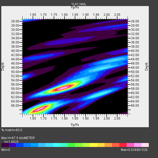
| Thickness Estimate: | 68 km |
| Thickness StdDev: | 5.5 km |
| Vp/Vs Estimate: | 1.68 |
| Vp/Vs StdDev: | 0.07 |
| Vs Estimate: | 3.872 km/s |
| Poisson's Ratio: | 0.23 |
| Peak Value: | 0.03 |
| Assumed Vp: | 6.514 km/s |
| Ps Weight: | 0.33333334 |
| PpPs Weight: | 0.33333334 |
| PsPs Weight: | 0.33333328 |
| Residual Complexity: | 0.722 |
| Nearby stations H: | +- |
| (2.0 deg) Vp/Vs: | +- |
3 with match > 90% ( 10.344828 %) and 13 with match > 80% ( 44.827587 %) out of 29.
Download stack as xyz text file.
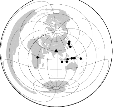
Azimuth Distribution of Events:
Prior Results for this Station
| Study | Thickness | Vp/Vs | Vp | Vs | Poissons Ratio | Extra |
| EARS | 68 km | 1.68 | 6.514 km/s | 3.872 km/s | 0.23 | |
| Crust2.0 | 70 km | 1.76 | 6.514 km/s | 3.706 km/s | 0.26 | RD,orogen/70km Tibet, no seds. |
| Global Maxima | 68 km | 1.68 | 6.514 km/s | 3.872 km/s | 0.23 | amp=0.034901526 |
| Local Maxima 1 | 58 km | 1.80 | 6.514 km/s | 3.629 km/s | 0.27 | amp=0.027892638 |
| Local Maxima 2 | 55 km | 1.84 | 6.514 km/s | 3.55 km/s | 0.29 | amp=0.014195477 |
| Local Maxima 3 | 60 km | 1.98 | 6.514 km/s | 3.286 km/s | 0.33 | amp=0.01083203 |
| Local Maxima 4 | 58 km | 1.75 | 6.514 km/s | 3.733 km/s | 0.26 | amp=0.010019062 |
| Predicted Arrivals for vertical incidence (zero ray parameter) | |
| Ps | 7.07 SECOND |
| PpPs | 27.80 SECOND |
| PsPs/PpSs | 34.87 SECOND |
Events Processed for this Station
Download zip of receiver functions as SAC
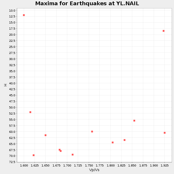
Plot maxima for each earthquake.
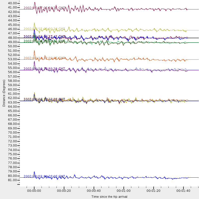
Events Used in the Stack
(13 events)| Radial Match | Distance | Baz | FERegion | Time | Lat/Lon | Depth | Magnitude |
| 95.29869 | 62.8 deg | 110.596 deg | Near N Coast Of New Guinea, P.N.G. | 2002/09/08 18:44:23 GMT | (-3.3, 142.9) | 13 km | 6.5 MB, 7.8 MS, 7.6 MW, 7.3 MW |
| 91.18967 | 54.9 deg | 115.054 deg | Irian Jaya Region, Indonesia | 2002/10/10 10:50:20 GMT | (-1.8, 134.3) | 10 km | 6.5 MB, 7.7 MS, 7.6 MW, 7.4 MW |
| 90.14642 | 62.6 deg | 110.775 deg | Near N Coast Of New Guinea, P.N.G. | 2002/09/16 13:23:00 GMT | (-3.3, 142.7) | 10 km | 5.9 MB, 5.9 MS, 6.3 MW, 6.1 MW |
| 89.49308 | 52.2 deg | 54.473 deg | Kuril Islands | 2002/10/19 12:09:05 GMT | (44.3, 150.0) | 33 km | 5.4 MB, 6.2 MS, 6.4 MW, 6.1 MW |
| 87.61328 | 54.8 deg | 115.026 deg | Irian Jaya Region, Indonesia | 2002/09/20 15:43:35 GMT | (-1.7, 134.2) | 10 km | 5.9 MB, 6.4 MS, 6.4 MW, 6.3 MW |
| 86.55658 | 47.9 deg | 135.099 deg | Sumbawa Region, Indonesia | 2002/10/06 15:46:33 GMT | (-8.2, 118.3) | 10 km | 5.8 MB, 6.0 MS, 6.2 MW, 6.2 MW |
| 86.34047 | 47.8 deg | 72.859 deg | Southeast Of Honshu, Japan | 2002/08/20 10:59:32 GMT | (31.0, 142.0) | 9.0 km | 5.4 MB, 6.2 MS, 6.3 MW, 6.1 MW |
| 84.445625 | 46.7 deg | 59.081 deg | Hokkaido, Japan Region | 2002/10/14 14:12:43 GMT | (41.2, 142.2) | 61 km | 5.9 MB, 6.1 MW, 6.1 MW |
| 83.94867 | 46.7 deg | 62.234 deg | Near East Coast Of Honshu, Japan | 2002/11/03 03:37:42 GMT | (38.9, 142.0) | 39 km | 5.7 MB, 6.1 MS, 6.4 MW, 6.4 MW |
| 83.73854 | 62.8 deg | 251.267 deg | Lake Tanganyika Region | 2002/10/24 06:08:37 GMT | (-1.9, 29.0) | 11 km | 5.9 MB, 6.3 MS, 6.2 MW, 6.1 MW |
| 83.244225 | 44.7 deg | 125.575 deg | Sulawesi, Indonesia | 2002/08/15 05:30:26 GMT | (-1.2, 121.3) | 10 km | 5.7 MB, 5.8 MS, 6.2 MW, 6.1 MW |
| 81.887 | 82.4 deg | 106.853 deg | Solomon Islands | 2002/10/03 04:26:06 GMT | (-11.0, 161.4) | 10 km | 5.6 MB, 5.6 MS, 5.9 MW, 5.7 MW |
| 81.37331 | 39.3 deg | 151.454 deg | Sunda Strait, Indonesia | 2002/06/27 05:50:35 GMT | (-7.0, 104.2) | 11 km | 6.0 MB, 6.9 MS, 6.6 MW, 6.5 MW |
Losers
(16 events)| Radial Match | Distance | Baz | FERegion | Time | Lat/Lon | Depth | Magnitude | Reason |
| 79.360725 | 37.9 deg | 52.84 deg | Northeastern China | 2002/09/15 08:39:32 GMT | (44.8, 129.9) | 586 km | 5.8 MB, 6.4 MW, 6.4 MW | |
| 79.288605 | 56.5 deg | 44.568 deg | Near East Coast Of Kamchatka | 2002/10/16 10:12:21 GMT | (52.0, 157.3) | 102 km | 6.1 MB, 6.2 MW, 6.2 MW | |
| 78.79285 | 54.9 deg | 122.594 deg | Banda Sea | 2002/07/30 20:02:06 GMT | (-6.5, 130.3) | 103 km | 5.5 MW, 5.4 MB, 5.3 MW | |
| 78.35654 | 48.9 deg | 135.718 deg | Sumbawa Region, Indonesia | 2002/07/24 03:05:05 GMT | (-9.3, 118.6) | 29 km | 5.8 MB, 5.4 MS, 5.9 MW, 5.9 MW | |
| 74.243195 | 32.6 deg | 107.622 deg | Philippine Islands Region | 2002/10/12 23:43:12 GMT | (15.1, 118.5) | 33 km | 5.6 MB, 5.6 MS, 6.1 MW | |
| 72.78102 | 39.3 deg | 151.712 deg | Sunda Strait, Indonesia | 2002/08/13 06:05:37 GMT | (-7.0, 104.0) | 33 km | 5.9 MS, 5.4 MB, 5.7 MW, 5.7 MW | |
| 71.38075 | 69.5 deg | 336.019 deg | Iceland Region | 2002/09/16 18:48:26 GMT | (66.9, -18.5) | 10 km | 5.5 MB, 5.7 MS, 5.8 MW, 5.8 MW | |
| 70.7701 | 35.2 deg | 108.047 deg | Mindoro, Philippines | 2002/09/03 14:23:45 GMT | (13.5, 120.8) | 10 km | 5.5 MB, 5.4 MS, 5.9 MW, 5.8 MW | |
| 68.51391 | 54.7 deg | 115.251 deg | Irian Jaya Region, Indonesia | 2002/09/20 13:33:41 GMT | (-1.7, 134.0) | 10 km | 5.7 MB, 5.9 MS, 6.0 MW, 6.0 MW | |
| 64.65656 | 45.7 deg | 137.413 deg | Bali Sea | 2002/10/03 19:05:10 GMT | (-7.5, 115.7) | 316 km | 6.0 MB, 6.0 MW, 6.0 MW | |
| 62.381947 | 58.4 deg | 303.482 deg | Southern Italy | 2002/11/01 15:09:00 GMT | (41.7, 14.9) | 10 km | 5.5 MB, 5.6 MS, 5.8 MW, 5.7 MW | |
| 61.0426 | 67.6 deg | 107.256 deg | Bismarck Sea | 2002/10/31 01:35:16 GMT | (-3.4, 148.6) | 10 km | 5.3 MB, 6.0 MS, 6.1 MW, 6.0 MW | |
| 59.08375 | 39.8 deg | 149.174 deg | Sunda Strait, Indonesia | 2002/08/26 14:55:13 GMT | (-6.8, 105.7) | 63 km | 5.6 MB, 5.8 MW, 5.7 MW | |
| 55.764885 | 54.6 deg | 114.921 deg | Irian Jaya Region, Indonesia | 2002/10/10 21:19:58 GMT | (-1.5, 134.1) | 10 km | 5.8 MB, 5.7 MS, 6.0 MW | |
| 50.077343 | 32.1 deg | 87.73 deg | Taiwan Region | 2002/09/16 00:03:29 GMT | (25.2, 122.3) | 183 km | 5.6 MW, 5.3 MB, 5.5 MW | |
| 38.671017 | 60.9 deg | 112.645 deg | Irian Jaya, Indonesia | 2002/10/19 00:43:56 GMT | (-3.7, 140.3) | 33 km | 5.3 MB, 5.9 MS, 6.1 MW, 6.0 MW |
