
Station YN PRAN - PRAN
Network: YN10 - San Jacinto Fault Zone
Nearby stations (2 deg radius)
| Station | Name | (Lat, Lon) | Start / End | Elevation |
| PRAN | PRAN | (33.66, -116.59) | 2012-07-06 / 2013-12-31 | 1673 m |
| Crust2 Type: | MG,very thin extended crust, 0.5 km seds. |
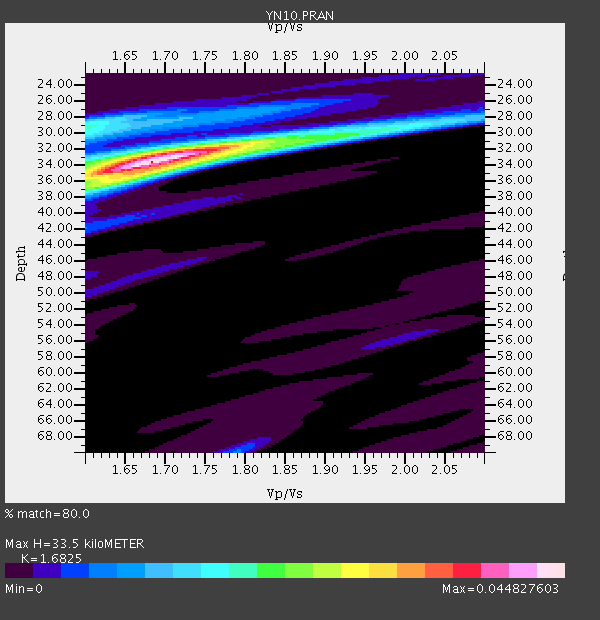
| Thickness Estimate: | 34 km |
| Thickness StdDev: | 1.1 km |
| Vp/Vs Estimate: | 1.68 |
| Vp/Vs StdDev: | 0.03 |
| Vs Estimate: | 3.723 km/s |
| Poisson's Ratio: | 0.23 |
| Peak Value: | 0.04 |
| Assumed Vp: | 6.264 km/s |
| Ps Weight: | 0.33333334 |
| PpPs Weight: | 0.33333334 |
| PsPs Weight: | 0.33333328 |
| Residual Complexity: | 0.477 |
| Nearby stations H: | +- |
| (2.0 deg) Vp/Vs: | +- |
4 with match > 90% ( 16.666666 %) and 10 with match > 80% ( 41.666668 %) out of 24.
Download stack as xyz text file.
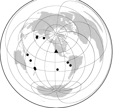
Azimuth Distribution of Events:
Prior Results for this Station
| Study | Thickness | Vp/Vs | Vp | Vs | Poissons Ratio | Extra |
| EARS | 34 km | 1.68 | 6.264 km/s | 3.723 km/s | 0.23 | |
| Crust2.0 | 28 km | 1.78 | 6.264 km/s | 3.524 km/s | 0.27 | MG,very thin extended crust, 0.5 km seds. |
| Global Maxima | 34 km | 1.68 | 6.264 km/s | 3.723 km/s | 0.23 | amp=0.044827603 |
| Local Maxima 1 | 29 km | 1.60 | 6.264 km/s | 3.915 km/s | 0.18 | amp=0.019990934 |
| Local Maxima 2 | 36 km | 1.62 | 6.264 km/s | 3.872 km/s | 0.19 | amp=0.017521437 |
| Local Maxima 3 | 32 km | 1.74 | 6.264 km/s | 3.605 km/s | 0.25 | amp=0.01594879 |
| Local Maxima 4 | 30 km | 1.96 | 6.264 km/s | 3.2 km/s | 0.32 | amp=0.011089969 |
| Predicted Arrivals for vertical incidence (zero ray parameter) | |
| Ps | 3.65 SECOND |
| PpPs | 14.35 SECOND |
| PsPs/PpSs | 18.00 SECOND |
Events Processed for this Station
Download zip of receiver functions as SAC
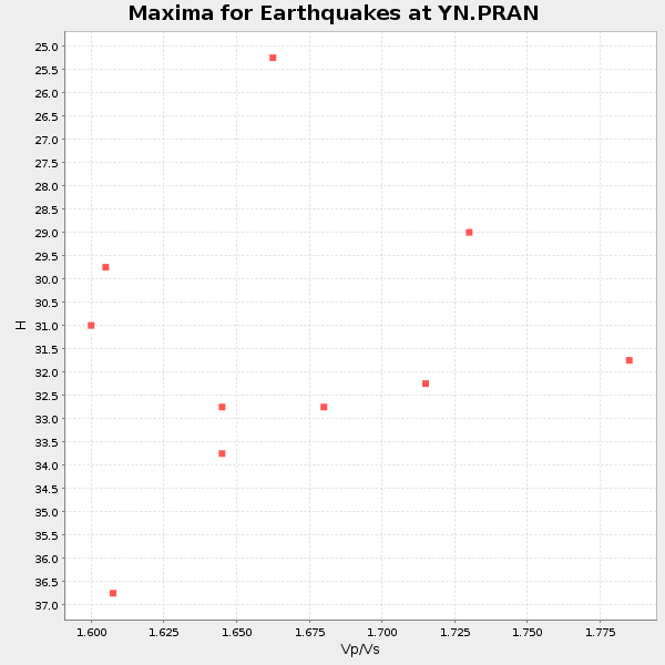
Plot maxima for each earthquake.
Events Used in the Stack
(10 events)| Radial Match | Distance | Baz | FERegion | Time | Lat/Lon | Depth | Magnitude |
| 95.62709 | 76.7 deg | 305.758 deg | Off East Coast Of Honshu, Japan | 2013/10/25 17:10:19 GMT | (37.2, 144.7) | 35 km | 7.1 MWW, 7.1 MWW, 7.1 MWB, 7.1 MWC, 7.2 MWC, 7.5 MI |
| 93.54451 | 50.8 deg | 133.085 deg | Near Coast Of Northern Peru | 2013/08/12 09:49:32 GMT | (-5.4, -81.9) | 10 km | 6.2 MWW, 6.1 MWB, 6.2 MWW, 6.2 MWC, 6.3 MWC |
| 93.10057 | 63.5 deg | 133.88 deg | Near Coast Of Peru | 2013/09/25 16:42:43 GMT | (-15.8, -74.5) | 40 km | 7.1 MWW, 6.8 MI, 7.0 MWB, 7.0 MWC, 7.1 MWW, 7.1 MWC |
| 90.41063 | 58.4 deg | 317.659 deg | Near East Coast Of Kamchatka | 2013/11/12 07:03:51 GMT | (54.7, 162.3) | 43 km | 6.4 MWW, 6.3 MWC, 6.4 MWW, 6.4 MWB, 6.5 MWC, 6.6 MI |
| 89.117905 | 92.3 deg | 263.819 deg | Solomon Islands | 2013/10/16 10:30:58 GMT | (-6.4, 154.9) | 35 km | 6.8 MWW, 6.7 MWB, 6.8 MWW, 6.8 MWC, 7.1 MI |
| 86.060776 | 86.4 deg | 250.889 deg | Vanuatu Islands | 2014/01/01 16:03:29 GMT | (-13.9, 167.2) | 187 km | 6.5 MWW, 6.5 MWC, 6.6 MWC, 6.6 MI, 6.6 MWB |
| 85.89367 | 57.1 deg | 175.634 deg | Easter Island Region | 2013/11/02 15:52:46 GMT | (-23.6, -112.6) | 10 km | 6.0 MWW, 5.9 MWB, 6.0 MWW, 6.0 MWC, 6.1 MWC |
| 83.675705 | 85.9 deg | 232.826 deg | Kermadec Islands Region | 2013/08/28 02:54:41 GMT | (-27.8, 179.6) | 478 km | 6.2 MWW, 6.2 MWW, 6.2 MWB, 6.2 MWC, 6.3 MWC |
| 80.82468 | 87.4 deg | 230.302 deg | Kermadec Islands Region | 2013/08/12 04:16:47 GMT | (-30.6, -179.7) | 341 km | 6.1 MWW, 6.1 MWC, 6.2 MWC, 6.2 MWB |
| 80.092865 | 78.0 deg | 307.898 deg | Near East Coast Of Honshu, Japan | 2013/08/04 03:28:50 GMT | (38.2, 141.9) | 56 km | 5.8 MW, 5.8 MB, 5.9 MW |
Losers
(14 events)| Radial Match | Distance | Baz | FERegion | Time | Lat/Lon | Depth | Magnitude | Reason |
| 83.085594 | 84.0 deg | 290.826 deg | Mariana Islands Region | 2013/12/17 23:38:06 GMT | (20.8, 146.8) | 9.0 km | 6.2 MWW, 6.1 MWB, 6.2 MWC, 6.4 MWC | |
| 79.105804 | 66.4 deg | 87.068 deg | Northern Mid-Atlantic Ridge | 2013/09/05 04:01:36 GMT | (15.2, -45.2) | 10 km | 6.0 MWW, 5.9 MWB, 6.0 MWW, 6.0 MWC | |
| 77.534096 | 47.8 deg | 311.635 deg | Andreanof Islands, Aleutian Is. | 2013/11/13 03:57:39 GMT | (51.5, -179.0) | 20 km | 5.8 MWW, 5.6 MWB, 5.7 MI, 5.8 MWW, 5.9 MWC, 6.0 ML | |
| 75.07777 | 84.7 deg | 302.474 deg | Southeast Of Honshu, Japan | 2013/09/04 00:18:23 GMT | (29.9, 138.8) | 402 km | 6.5 MWW, 6.5 MWW, 6.5 MWB, 6.5 MWC | |
| 72.429245 | 86.7 deg | 229.298 deg | Kermadec Islands, New Zealand | 2013/09/30 05:55:55 GMT | (-30.9, -178.3) | 42 km | 6.5 MWW, 6.4 MWC, 6.5 MWW, 6.5 MWB, 6.7 MI | |
| 69.61116 | 72.0 deg | 133.632 deg | Northern Chile | 2013/08/23 08:34:06 GMT | (-22.3, -68.6) | 111 km | 5.8 MWW, 5.7 MWD, 5.8 MWW, 5.8 MWB, 5.8 MWC | |
| 67.06083 | 76.2 deg | 238.456 deg | Fiji Islands Region | 2013/11/23 07:48:32 GMT | (-17.1, -176.5) | 371 km | 6.5 MWW, 6.4 MI, 6.5 MWC, 6.5 MWB | |
| 66.092064 | 54.4 deg | 101.317 deg | Near Coast Of Venezuela | 2013/10/12 02:10:27 GMT | (10.9, -62.3) | 63 km | 6.0 MWW, 6.0 MWW, 6.0 MWB, 6.0 MWC, 6.0 MI | |
| 61.43669 | 83.4 deg | 306.933 deg | Near S. Coast Of Honshu, Japan | 2013/11/18 19:10:45 GMT | (34.3, 137.0) | 328 km | 5.6 MWW, 5.7 MWB, 5.7 MWC | |
| 60.17836 | 97.0 deg | 267.633 deg | New Britain Region, P.N.G. | 2013/11/03 02:42:54 GMT | (-5.9, 148.9) | 89 km | 5.8 MWW, 5.7 MWB, 5.8 MWW, 5.9 MWC | |
| 60.00718 | 84.1 deg | 290.876 deg | Mariana Islands Region | 2013/12/28 19:31:23 GMT | (20.8, 146.7) | 12 km | 5.6 MWC, 5.6 MWC | |
| 52.816242 | 86.5 deg | 289.759 deg | Mariana Islands | 2013/11/19 17:00:44 GMT | (18.5, 145.2) | 511 km | 6.0 MWW, 6.0 MWC, 6.0 MWB | |
| 44.789707 | 92.8 deg | 286.651 deg | South Of Mariana Islands | 2013/10/06 16:38:08 GMT | (12.3, 141.7) | 104 km | 6.0 MWW, 6.0 MWB, 6.0 MWW, 6.1 MWC | |
| 41.591923 | 68.4 deg | 310.984 deg | Kuril Islands | 2013/11/25 05:56:50 GMT | (45.6, 151.0) | 34 km | 6.0 MWW, 5.8 MWB, 6.0 MWC |

