
Station YN SFTR - SFTR
Network: YN10 - San Jacinto Fault Zone
Nearby stations (2 deg radius)
| Station | Name | (Lat, Lon) | Start / End | Elevation |
| SFTR | SFTR | (33.64, -116.75) | 2011-10-02 / 2015-12-31 | 1242 m |
| Crust2 Type: | MG,very thin extended crust, 0.5 km seds. |
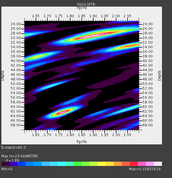
| Thickness Estimate: | 29 km |
| Thickness StdDev: | 3.6 km |
| Vp/Vs Estimate: | 1.89 |
| Vp/Vs StdDev: | 0.09 |
| Vs Estimate: | 3.314 km/s |
| Poisson's Ratio: | 0.31 |
| Peak Value: | 0.16 |
| Assumed Vp: | 6.264 km/s |
| Ps Weight: | 0.33333334 |
| PpPs Weight: | 0.33333334 |
| PsPs Weight: | 0.33333328 |
| Residual Complexity: | 0.708 |
| Nearby stations H: | +- |
| (2.0 deg) Vp/Vs: | +- |
0 with match > 90% ( 0.0 %) and 2 with match > 80% ( 10.526316 %) out of 19.
Download stack as xyz text file.
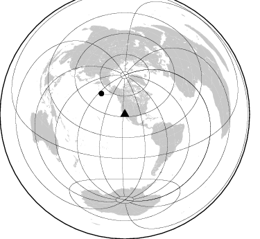
Azimuth Distribution of Events:
Prior Results for this Station
| Study | Thickness | Vp/Vs | Vp | Vs | Poissons Ratio | Extra |
| EARS | 29 km | 1.89 | 6.264 km/s | 3.314 km/s | 0.31 | |
| Crust2.0 | 28 km | 1.78 | 6.264 km/s | 3.524 km/s | 0.27 | MG,very thin extended crust, 0.5 km seds. |
| Global Maxima | 29 km | 1.89 | 6.264 km/s | 3.314 km/s | 0.31 | amp=0.15825619 |
| Local Maxima 1 | 62 km | 1.76 | 6.264 km/s | 3.549 km/s | 0.26 | amp=0.14930193 |
| Local Maxima 2 | 33 km | 2.06 | 6.264 km/s | 3.048 km/s | 0.34 | amp=0.12305566 |
| Local Maxima 3 | 29 km | 1.60 | 6.264 km/s | 3.915 km/s | 0.18 | amp=0.07841764 |
| Local Maxima 4 | 60 km | 2.09 | 6.264 km/s | 2.993 km/s | 0.35 | amp=0.07188197 |
| Predicted Arrivals for vertical incidence (zero ray parameter) | |
| Ps | 4.12 SECOND |
| PpPs | 13.38 SECOND |
| PsPs/PpSs | 17.50 SECOND |
Events Processed for this Station
Download zip of receiver functions as SAC
Plot maxima for each earthquake.
Events Used in the Stack
(2 events)| Radial Match | Distance | Baz | FERegion | Time | Lat/Lon | Depth | Magnitude |
| 89.71772 | 45.3 deg | 311.525 deg | Andreanof Islands, Aleutian Is. | 2013/08/30 16:25:02 GMT | (51.5, -175.2) | 29 km | 7.0 MWW, 6.5 ML, 6.8 MI, 6.9 MWC, 6.9 MWB, 7.0 MWW, 7.0 MI, 7.0 MWC |
| 87.48073 | 45.0 deg | 311.578 deg | Andreanof Islands, Aleutian Is. | 2013/09/15 16:21:37 GMT | (51.6, -174.7) | 24 km | 6.1 MWW, 5.7 MI, 5.7 ML, 6.0 MWB, 6.1 MWC, 6.1 MWW |
Losers
(17 events)| Radial Match | Distance | Baz | FERegion | Time | Lat/Lon | Depth | Magnitude | Reason |
| 87.65554 | 63.6 deg | 133.741 deg | Near Coast Of Peru | 2013/09/25 16:42:43 GMT | (-15.8, -74.5) | 40 km | 7.1 MWW, 6.8 MI, 7.0 MWB, 7.0 MWC, 7.1 MWW, 7.1 MWC | |
| 85.68549 | 45.2 deg | 119.141 deg | South Of Panama | 2013/08/13 15:43:15 GMT | (5.8, -78.2) | 12 km | 6.7 MWW, 6.6 MWB, 6.7 MWW, 6.7 MWC, 6.7 MI | |
| 79.48253 | 45.1 deg | 311.102 deg | Andreanof Islands, Aleutian Is. | 2013/08/31 06:38:36 GMT | (51.2, -174.9) | 18 km | 6.0 MWW, 5.5 ML, 5.9 MWB, 5.9 MWC, 6.0 MWC, 6.0 MI, 6.0 MWW | |
| 73.10106 | 45.0 deg | 311.386 deg | Andreanof Islands, Aleutian Is. | 2013/09/14 15:42:46 GMT | (51.4, -174.6) | 20 km | 5.9 MWW, 5.4 MI, 5.8 MWB, 5.9 MWC, 6.0 MWC | |
| 72.49626 | 77.9 deg | 307.831 deg | Near East Coast Of Honshu, Japan | 2013/08/04 03:28:50 GMT | (38.2, 141.9) | 56 km | 5.8 MW, 5.8 MB, 5.9 MW | |
| 66.82912 | 66.5 deg | 86.977 deg | Northern Mid-Atlantic Ridge | 2013/09/05 04:01:36 GMT | (15.2, -45.2) | 10 km | 6.0 MWW, 5.9 MWB, 6.0 MWW, 6.0 MWC | |
| 65.31561 | 50.9 deg | 132.915 deg | Near Coast Of Northern Peru | 2013/08/12 09:49:32 GMT | (-5.4, -81.9) | 10 km | 6.2 MWW, 6.1 MWB, 6.2 MWW, 6.2 MWC, 6.3 MWC | |
| 65.21166 | 72.1 deg | 133.512 deg | Northern Chile | 2013/08/23 08:34:06 GMT | (-22.3, -68.6) | 111 km | 5.8 MWW, 5.7 MWD, 5.8 MWW, 5.8 MWB, 5.8 MWC | |
| 63.809383 | 87.9 deg | 241.551 deg | Southeast Of Loyalty Islands | 2013/08/21 04:43:18 GMT | (-22.3, 171.7) | 92 km | 5.7 MWW, 5.7 MWB, 5.7 MWC | |
| 60.286617 | 71.2 deg | 314.27 deg | Sea Of Okhotsk | 2013/08/04 15:56:34 GMT | (47.0, 145.2) | 375 km | 5.8 MW, 5.8 MW | |
| 60.193096 | 92.1 deg | 263.469 deg | Solomon Islands | 2013/09/02 04:30:16 GMT | (-6.6, 155.1) | 35 km | 5.9 MWW, 5.8 MWB, 6.0 MWC | |
| 58.92303 | 80.7 deg | 314.818 deg | Primor'ye, Russia | 2013/09/02 02:51:13 GMT | (42.2, 133.7) | 445 km | 5.7 MWW, 5.7 MWW, 5.7 MWB, 5.7 MWC | |
| 51.855354 | 87.3 deg | 230.212 deg | Kermadec Islands Region | 2013/08/12 04:16:47 GMT | (-30.6, -179.7) | 341 km | 6.1 MWW, 6.1 MWC, 6.2 MWC, 6.2 MWB | |
| 50.62794 | 72.7 deg | 237.726 deg | Tonga Islands | 2013/08/01 20:01:43 GMT | (-15.2, -173.5) | 32 km | 6.0 MW, 5.8 MW, 5.9 MS, 6.1 MB | |
| 50.59705 | 35.8 deg | 123.209 deg | Off Coast Of Costa Rica | 2013/08/12 05:18:59 GMT | (10.5, -86.9) | 22 km | 5.5 MW, 5.5 MWC, 5.5 MWC | |
| 49.803513 | 85.8 deg | 232.734 deg | Kermadec Islands Region | 2013/08/28 02:54:41 GMT | (-27.8, 179.6) | 478 km | 6.2 MWW, 6.2 MWW, 6.2 MWB, 6.2 MWC, 6.3 MWC | |
| 48.893036 | 79.4 deg | 238.331 deg | Fiji Islands Region | 2013/08/29 13:52:27 GMT | (-19.4, -179.1) | 662 km | 5.7 MWW, 5.7 MWW, 5.8 MWC, 5.8 MWB |
