
Station YN WRDG - WRDG
Network: YN10 - San Jacinto Fault Zone
Nearby stations (2 deg radius)
| Station | Name | (Lat, Lon) | Start / End | Elevation |
| WRDG | WRDG | (33.73, -116.73) | 2012-07-06 / 2013-12-31 | 1599 m |
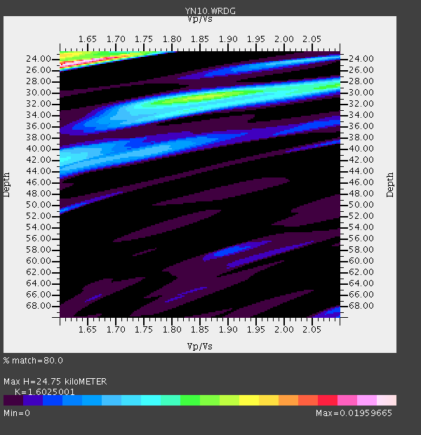
| Crust2 Type: | MG,very thin extended crust, 0.5 km seds. |
| Thickness Estimate: | 25 km |
| Thickness StdDev: | 11 km |
| Vp/Vs Estimate: | 1.60 |
| Vp/Vs StdDev: | 0.22 |
| Vs Estimate: | 3.909 km/s |
| Poisson's Ratio: | 0.18 |
| Peak Value: | 0.02 |
| Assumed Vp: | 6.264 km/s |
| Ps Weight: | 0.33333334 |
| PpPs Weight: | 0.33333334 |
| PsPs Weight: | 0.33333328 |
| Residual Complexity: | 0.831 |
| Nearby stations H: | +- |
| (2.0 deg) Vp/Vs: | +- |
3 with match > 90% ( 16.666666 %) and 6 with match > 80% ( 33.333332 %) out of 18.
Download stack as xyz text file.
Azimuth Distribution of Events:

Prior Results for this Station
| Study | Thickness | Vp/Vs | Vp | Vs | Poissons Ratio | Extra |
| EARS | 25 km | 1.60 | 6.264 km/s | 3.909 km/s | 0.18 | |
| Crust2.0 | 28 km | 1.78 | 6.264 km/s | 3.524 km/s | 0.27 | MG,very thin extended crust, 0.5 km seds. |
| Global Maxima | 25 km | 1.60 | 6.264 km/s | 3.909 km/s | 0.18 | amp=0.01959665 |
| Local Maxima 1 | 30 km | 1.86 | 6.264 km/s | 3.372 km/s | 0.30 | amp=0.0111876 |
| Local Maxima 2 | 23 km | 1.60 | 6.264 km/s | 3.909 km/s | 0.18 | amp=0.010401256 |
| Local Maxima 3 | 28 km | 2.10 | 6.264 km/s | 2.986 km/s | 0.35 | amp=0.0072144526 |
| Local Maxima 4 | 42 km | 1.60 | 6.264 km/s | 3.915 km/s | 0.18 | amp=0.0070676017 |
| Predicted Arrivals for vertical incidence (zero ray parameter) | |
| Ps | 2.38 SECOND |
| PpPs | 10.28 SECOND |
| PsPs/PpSs | 12.66 SECOND |
Events Processed for this Station
Download zip of receiver functions as SAC
Plot maxima for each earthquake.
Events Used in the Stack
(6 events)| Radial Match | Distance | Baz | FERegion | Time | Lat/Lon | Depth | Magnitude |
| 93.43709 | 63.6 deg | 133.793 deg | Near Coast Of Peru | 2013/09/25 16:42:43 GMT | (-15.8, -74.5) | 40 km | 7.1 MWW, 6.8 MI, 7.0 MWB, 7.0 MWC, 7.1 MWW, 7.1 MWC |
| 91.78463 | 45.3 deg | 119.241 deg | South Of Panama | 2013/08/13 15:43:15 GMT | (5.8, -78.2) | 12 km | 6.7 MWW, 6.6 MWB, 6.7 MWW, 6.7 MWC, 6.7 MI |
| 91.63236 | 51.0 deg | 132.992 deg | Near Coast Of Northern Peru | 2013/08/12 09:49:32 GMT | (-5.4, -81.9) | 10 km | 6.2 MWW, 6.1 MWB, 6.2 MWW, 6.2 MWC, 6.3 MWC |
| 89.85834 | 92.2 deg | 263.748 deg | Solomon Islands | 2013/10/16 10:30:58 GMT | (-6.4, 154.9) | 35 km | 6.8 MWW, 6.7 MWB, 6.8 MWW, 6.8 MWC, 7.1 MI |
| 82.47585 | 66.5 deg | 87.028 deg | Northern Mid-Atlantic Ridge | 2013/09/05 04:01:36 GMT | (15.2, -45.2) | 10 km | 6.0 MWW, 5.9 MWB, 6.0 MWW, 6.0 MWC |
| 80.4564 | 85.9 deg | 232.742 deg | Kermadec Islands Region | 2013/08/28 02:54:41 GMT | (-27.8, 179.6) | 478 km | 6.2 MWW, 6.2 MWW, 6.2 MWB, 6.2 MWC, 6.3 MWC |
Losers
(12 events)| Radial Match | Distance | Baz | FERegion | Time | Lat/Lon | Depth | Magnitude | Reason |
| 81.87365 | 72.8 deg | 237.718 deg | Tonga Islands | 2013/08/01 20:01:43 GMT | (-15.2, -173.5) | 32 km | 6.0 MW, 5.8 MW, 5.9 MS, 6.1 MB | |
| 79.71405 | 87.3 deg | 230.222 deg | Kermadec Islands Region | 2013/08/12 04:16:47 GMT | (-30.6, -179.7) | 341 km | 6.1 MWW, 6.1 MWC, 6.2 MWC, 6.2 MWB | |
| 76.742226 | 86.6 deg | 240.178 deg | Southeast Of Loyalty Islands | 2013/08/06 10:41:30 GMT | (-22.5, 173.8) | 10 km | 5.8 MWW, 5.8 MWB, 5.9 MWC | |
| 73.78367 | 54.5 deg | 101.278 deg | Near Coast Of Venezuela | 2013/10/12 02:10:27 GMT | (10.9, -62.3) | 63 km | 6.0 MWW, 6.0 MWW, 6.0 MWB, 6.0 MWC, 6.0 MI | |
| 72.79622 | 88.2 deg | 227.152 deg | South Of Kermadec Islands | 2013/09/21 16:48:58 GMT | (-33.5, -178.0) | 10 km | 5.8 MWW, 5.7 MWC, 5.8 MWW | |
| 64.30447 | 45.0 deg | 311.511 deg | Andreanof Islands, Aleutian Is. | 2013/09/15 16:21:37 GMT | (51.6, -174.7) | 24 km | 6.1 MWW, 5.7 MI, 5.7 ML, 6.0 MWB, 6.1 MWC, 6.1 MWW | |
| 62.407093 | 45.0 deg | 311.509 deg | Andreanof Islands, Aleutian Is. | 2013/09/04 06:16:49 GMT | (51.6, -174.8) | 21 km | 5.7 MWW, 5.5 ML, 5.5 MI, 5.7 MWB, 5.7 MWW, 5.8 MWC | |
| 58.447563 | 45.0 deg | 311.332 deg | Andreanof Islands, Aleutian Is. | 2013/09/04 04:16:30 GMT | (51.4, -174.7) | 27 km | 5.9 MW, 5.2 ML, 5.4 ML, 5.8 MWW, 5.8 MWW, 5.9 MWC | |
| 54.36958 | 64.1 deg | 318.016 deg | Sea Of Okhotsk | 2013/10/01 03:38:21 GMT | (53.2, 152.8) | 573 km | 6.7 MWW, 6.7 MWC, 6.8 MWC, 6.8 MWB | |
| 52.890564 | 72.1 deg | 133.55 deg | Northern Chile | 2013/08/23 08:34:06 GMT | (-22.3, -68.6) | 111 km | 5.8 MWW, 5.7 MWD, 5.8 MWW, 5.8 MWB, 5.8 MWC | |
| 49.593864 | 88.0 deg | 248.355 deg | Vanuatu Islands | 2013/08/06 16:46:18 GMT | (-16.9, 167.3) | 10 km | 5.7 MWW, 5.7 MWW, 5.7 MWC, 5.9 MWB | |
| 48.269775 | 39.8 deg | 160.854 deg | Central East Pacific Rise | 2013/09/11 12:44:13 GMT | (-4.5, -104.6) | 10 km | 6.1 MWW, 6.0 MWB, 6.1 MWW, 6.1 MWC |
