
Station YO ECHS - East Carteret High School
Network: YO14 - Eastern North America Community Seismic Experiment
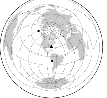
Nearby stations (2 deg radius)
| Station | Name | (Lat, Lon) | Start / End | Elevation |
| ECHS | East Carteret High School | (34.78, -76.63) | 2014-05-14 / 2015-06-30 | 1.0 m |
| Crust2 Type: | DG,thin Platform 1 km seds. |
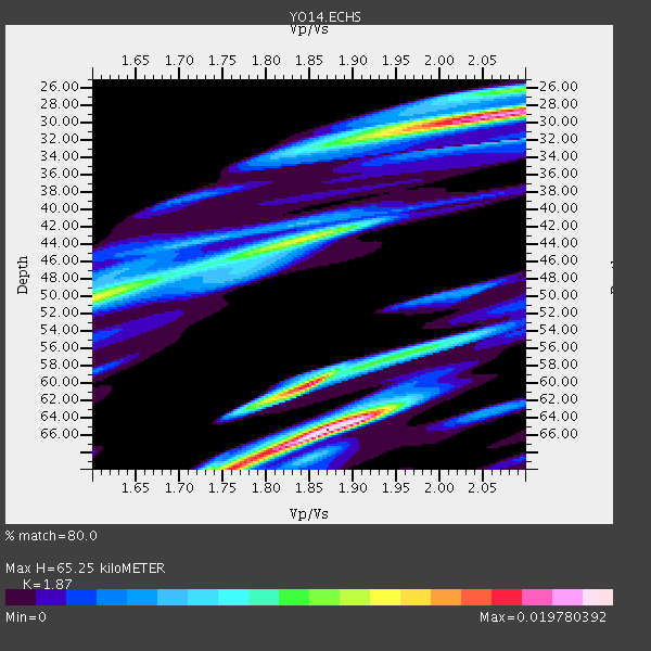
| Thickness Estimate: | 65 km |
| Thickness StdDev: | 14 km |
| Vp/Vs Estimate: | 1.87 |
| Vp/Vs StdDev: | 0.03 |
| Vs Estimate: | 3.51 km/s |
| Poisson's Ratio: | 0.30 |
| Peak Value: | 0.02 |
| Assumed Vp: | 6.565 km/s |
| Ps Weight: | 0.33333334 |
| PpPs Weight: | 0.33333334 |
| PsPs Weight: | 0.33333328 |
| Residual Complexity: | 0.848 |
| Nearby stations H: | +- |
| (2.0 deg) Vp/Vs: | +- |
1 with match > 90% ( 10.0 %) and 2 with match > 80% ( 20.0 %) out of 10.
Download stack as xyz text file.
Azimuth Distribution of Events:
Prior Results for this Station
| Study | Thickness | Vp/Vs | Vp | Vs | Poissons Ratio | Extra |
| EARS | 65 km | 1.87 | 6.565 km/s | 3.51 km/s | 0.30 | |
| Crust2.0 | 31 km | 1.78 | 6.565 km/s | 3.684 km/s | 0.27 | DG,thin Platform 1 km seds. |
| Global Maxima | 65 km | 1.87 | 6.565 km/s | 3.51 km/s | 0.30 | amp=0.019780392 |
| Local Maxima 1 | 29 km | 2.09 | 6.565 km/s | 3.148 km/s | 0.35 | amp=0.01810768 |
| Local Maxima 2 | 60 km | 1.85 | 6.565 km/s | 3.548 km/s | 0.29 | amp=0.01694004 |
| Local Maxima 3 | 70 km | 1.76 | 6.565 km/s | 3.725 km/s | 0.26 | amp=0.012311256 |
| Local Maxima 4 | 43 km | 1.84 | 6.565 km/s | 3.563 km/s | 0.29 | amp=0.012185754 |
| Predicted Arrivals for vertical incidence (zero ray parameter) | |
| Ps | 8.65 SECOND |
| PpPs | 28.53 SECOND |
| PsPs/PpSs | 37.17 SECOND |
Events Processed for this Station
Download zip of receiver functions as SAC
Plot maxima for each earthquake.
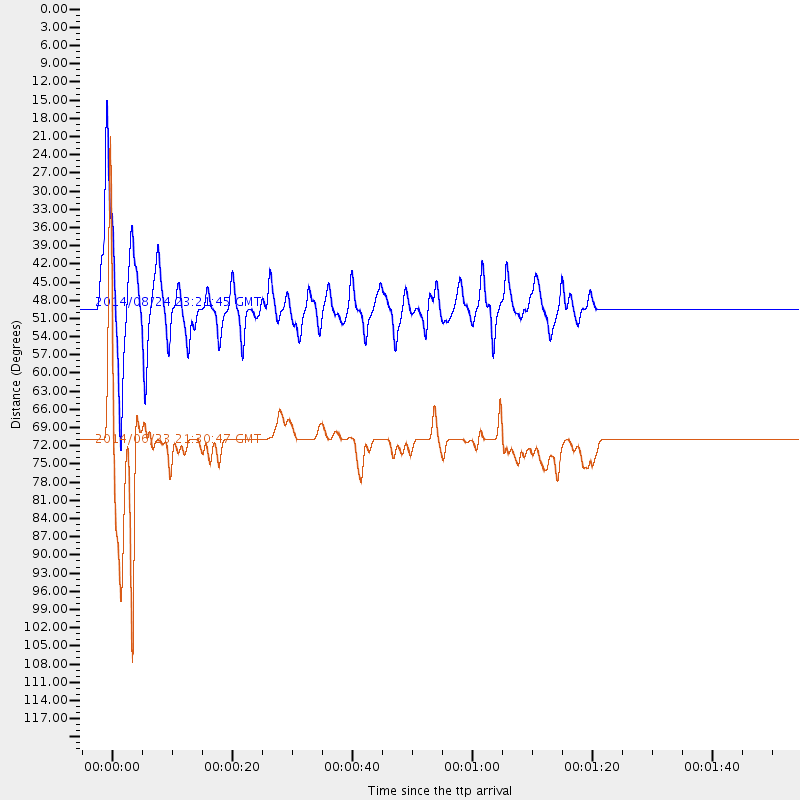
Events Used in the Stack
(2 events)| Radial Match | Distance | Baz | FERegion | Time | Lat/Lon | Depth | Magnitude |
| 93.21726 | 49.2 deg | 176.093 deg | Central Peru | 2014/08/24 23:21:45 GMT | (-14.6, -73.6) | 101 km | 6.9 MWW, 6.8 MI, 6.9 MWB |
| 88.02852 | 71.7 deg | 321.016 deg | Rat Islands, Aleutian Islands | 2014/06/23 21:30:47 GMT | (52.0, 178.4) | 109 km | 5.9 MB |
Losers
(8 events)| Radial Match | Distance | Baz | FERegion | Time | Lat/Lon | Depth | Magnitude | Reason |
| 96.5866 | 71.6 deg | 320.697 deg | Rat Islands, Aleutian Islands | 2014/06/23 20:53:09 GMT | (51.8, 178.8) | 108 km | 7.9 MWW, 7.1 MI, 7.9 MWC | |
| 73.337814 | 71.7 deg | 320.97 deg | Rat Islands, Aleutian Islands | 2014/06/23 21:11:41 GMT | (52.0, 178.4) | 107 km | 6.0 MB | |
| 60.780582 | 45.9 deg | 320.269 deg | Southeastern Alaska | 2014/07/25 10:54:49 GMT | (58.4, -137.1) | 10 km | 5.9 MWP | |
| 58.831337 | 90.9 deg | 329.461 deg | Kuril Islands | 2014/07/20 18:32:47 GMT | (44.6, 148.7) | 61 km | 6.6 MB | |
| 54.31386 | 83.0 deg | 342.853 deg | Southeastern Siberia, Russia | 2014/07/25 11:06:52 GMT | (58.4, 137.1) | 10 km | 1.5 ML, 5.9 Md | |
| 39.504086 | 95.0 deg | 44.385 deg | Iran-Iraq Border Region | 2014/08/18 18:09:08 GMT | (32.6, 47.7) | 30 km | 5.1 mb, 4.5 ms1mx, 5.8 Ms1, 5.8 MS, 5.3 ML, 5.3 mbtmp, 5.0 mb1mx, 5.2 mb1, 5.1 mb | |
| 33.309277 | 67.3 deg | 317.29 deg | Andreanof Islands, Aleutian Is. | 2014/08/10 18:27:38 GMT | (51.2, -172.8) | 22 km | 5.0 MW, 4.4 ML, 5.0 mb | |
| 20.631966 | 96.1 deg | 331.766 deg | Hokkaido, Japan Region | 2014/07/25 04:18:16 GMT | (41.6, 142.2) | 64 km | 5.0 MW, 5.1 mb |

