
Station YQ MBHS - Matema,Tanzania
Network: YQ13 - Study of Extension and Magmatism in Malawi and Tanzania
Nearby stations (2 deg radius)
| Station | Name | (Lat, Lon) | Start / End | Elevation |
| MBHS | Matema,Tanzania | (-9.43, 33.98) | 2013-08-10 / 2015-11-04 | 560 m |
| Crust2 Type: | X2,Rift, Rio Grande, Baikal, 0.5km sediments |
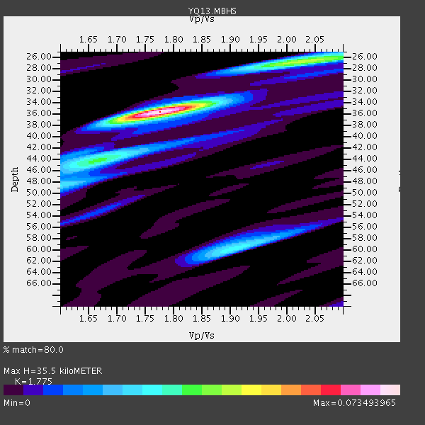
| Thickness Estimate: | 36 km |
| Thickness StdDev: | 5.2 km |
| Vp/Vs Estimate: | 1.77 |
| Vp/Vs StdDev: | 0.07 |
| Vs Estimate: | 3.663 km/s |
| Poisson's Ratio: | 0.27 |
| Peak Value: | 0.07 |
| Assumed Vp: | 6.502 km/s |
| Ps Weight: | 0.33333334 |
| PpPs Weight: | 0.33333334 |
| PsPs Weight: | 0.33333328 |
| Residual Complexity: | 0.620 |
| Nearby stations H: | +- |
| (2.0 deg) Vp/Vs: | +- |
2 with match > 90% ( 11.111111 %) and 3 with match > 80% ( 16.666666 %) out of 18.
Download stack as xyz text file.
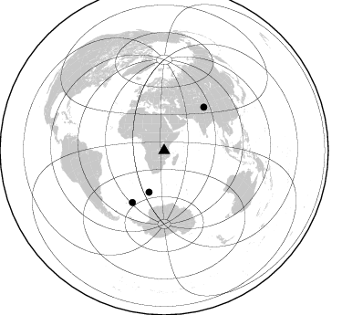
Azimuth Distribution of Events:
Prior Results for this Station
| Study | Thickness | Vp/Vs | Vp | Vs | Poissons Ratio | Extra |
| EARS | 36 km | 1.77 | 6.502 km/s | 3.663 km/s | 0.27 | |
| Crust2.0 | 33 km | 1.77 | 6.502 km/s | 3.68 km/s | 0.26 | X2,Rift, Rio Grande, Baikal, 0.5km sediments |
| Global Maxima | 36 km | 1.77 | 6.502 km/s | 3.663 km/s | 0.27 | amp=0.073493965 |
| Local Maxima 1 | 26 km | 2.03 | 6.502 km/s | 3.199 km/s | 0.34 | amp=0.040166743 |
| Local Maxima 2 | 44 km | 1.67 | 6.502 km/s | 3.887 km/s | 0.22 | amp=0.03186367 |
| Local Maxima 3 | 60 km | 1.91 | 6.502 km/s | 3.404 km/s | 0.31 | amp=0.027761133 |
| Local Maxima 4 | 48 km | 1.60 | 6.502 km/s | 4.063 km/s | 0.18 | amp=0.019811958 |
| Predicted Arrivals for vertical incidence (zero ray parameter) | |
| Ps | 4.23 SECOND |
| PpPs | 15.15 SECOND |
| PsPs/PpSs | 19.38 SECOND |
Events Processed for this Station
Download zip of receiver functions as SAC
Plot maxima for each earthquake.
Events Used in the Stack
(3 events)| Radial Match | Distance | Baz | FERegion | Time | Lat/Lon | Depth | Magnitude |
| 93.86209 | 48.5 deg | 199.918 deg | Bouvet Island Region | 2014/04/15 03:57:02 GMT | (-53.5, 8.7) | 12 km | 6.9 MWP, 6.8 MI, 6.9 MI |
| 92.98976 | 66.7 deg | 211.69 deg | South Sandwich Islands Region | 2014/02/01 03:58:43 GMT | (-56.8, -27.3) | 130 km | 6.1 MWW, 6.1 MWC, 6.1 MWB, 6.2 MWC |
| 87.042885 | 64.2 deg | 42.549 deg | Xizang | 2014/02/12 09:19:49 GMT | (35.9, 82.6) | 10 km | 6.9 MWW, 6.9 MWB, 6.9 MWC |
Losers
(15 events)| Radial Match | Distance | Baz | FERegion | Time | Lat/Lon | Depth | Magnitude | Reason |
| 96.68455 | 62.4 deg | 76.379 deg | Nicobar Islands, India Region | 2014/03/21 14:11:13 GMT | (7.5, 94.3) | 10 km | 5.5 MB | |
| 81.78321 | 49.1 deg | 345.834 deg | Greece | 2014/02/03 03:08:46 GMT | (38.3, 20.4) | 5.0 km | 6.0 MWW, 6.0 MWB, 6.1 MWC | |
| 72.769745 | 68.5 deg | 60.856 deg | Myanmar | 2014/01/26 12:38:40 GMT | (22.9, 95.8) | 32 km | 5.1 MW | |
| 70.725006 | 97.3 deg | 63.437 deg | Ryukyu Islands, Japan | 2014/03/02 20:11:23 GMT | (27.4, 127.4) | 119 km | 6.5 MWW, 6.4 MWB, 6.5 MWC, 6.6 MI, 6.7 MI | |
| 69.35176 | 93.3 deg | 97.624 deg | Banda Sea | 2014/01/05 21:29:35 GMT | (-7.0, 128.5) | 38 km | 5.3 MW | |
| 68.76295 | 83.9 deg | 297.859 deg | Northern Mid-Atlantic Ridge | 2014/01/18 22:19:28 GMT | (26.3, -44.4) | 11 km | 5.4 MW | |
| 66.16919 | 47.9 deg | 199.674 deg | Southwest Of Africa | 2014/03/08 07:14:09 GMT | (-53.2, 9.5) | 10 km | 5.4 MW | |
| 63.88165 | 57.2 deg | 35.0 deg | Hindu Kush Region, Afghanistan | 2014/03/19 14:15:43 GMT | (36.5, 70.7) | 193 km | 4.7 mb | |
| 62.063076 | 93.1 deg | 98.02 deg | Banda Sea | 2014/02/04 01:05:34 GMT | (-7.4, 128.4) | 35 km | 5.1 MW | |
| 61.776104 | 95.6 deg | 97.054 deg | Banda Sea | 2014/03/19 14:38:09 GMT | (-6.1, 130.7) | 124 km | 5.0 MW | |
| 60.400795 | 92.4 deg | 79.141 deg | Leyte, Philippines | 2014/01/26 06:12:03 GMT | (11.2, 124.6) | 15 km | 5.0 MW | |
| 60.080517 | 76.9 deg | 58.235 deg | Sichuan, China | 2014/04/04 22:40:34 GMT | (28.1, 103.6) | 19 km | 4.9 MW | |
| 51.235195 | 92.2 deg | 66.096 deg | Taiwan Region | 2014/03/19 12:19:24 GMT | (24.1, 122.3) | 10 km | 5.6 MWB, 5.8 MWW, 5.8 MWC | |
| 50.752636 | 56.3 deg | 275.295 deg | Central Mid-Atlantic Ridge | 2014/03/29 07:46:50 GMT | (-0.8, -21.9) | 12 km | 5.9 MWW, 5.8 MWB, 6.0 MWC | |
| 35.740845 | 92.4 deg | 66.227 deg | Taiwan Region | 2014/03/17 13:12:55 GMT | (24.0, 122.4) | 25 km | 5.1 MW |

