
Station YR ED05 - ORTOLANO
Network: YR16 - Armatrice Sequence International
Nearby stations (2 deg radius)
| Station | Name | (Lat, Lon) | Start / End | Elevation |
| ED05 | ORTOLANO | (42.48, 13.36) | 2016-08-30 / 2017-12-16 | 1187 m |
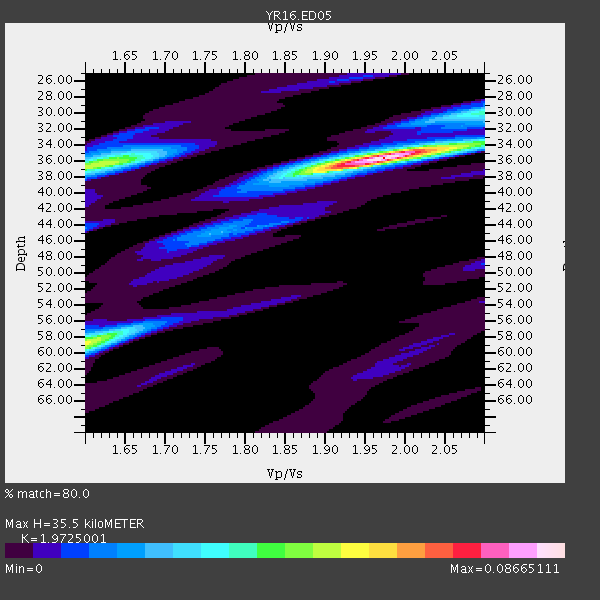
| Crust2 Type: | M5,extended crust, 0.5 km seds. |
| Thickness Estimate: | 36 km |
| Thickness StdDev: | 4.1 km |
| Vp/Vs Estimate: | 1.97 |
| Vp/Vs StdDev: | 0.11 |
| Vs Estimate: | 3.182 km/s |
| Poisson's Ratio: | 0.33 |
| Peak Value: | 0.09 |
| Assumed Vp: | 6.276 km/s |
| Ps Weight: | 0.33333334 |
| PpPs Weight: | 0.33333334 |
| PsPs Weight: | 0.33333328 |
| Residual Complexity: | 0.502 |
| Nearby stations H: | +- |
| (2.0 deg) Vp/Vs: | +- |
1 with match > 90% ( 2.0408163 %) and 6 with match > 80% ( 12.244898 %) out of 49.
Download stack as xyz text file.
Azimuth Distribution of Events:

Prior Results for this Station
| Study | Thickness | Vp/Vs | Vp | Vs | Poissons Ratio | Extra |
| EARS | 36 km | 1.97 | 6.276 km/s | 3.182 km/s | 0.33 | |
| Crust2.0 | 31 km | 1.78 | 6.276 km/s | 3.529 km/s | 0.27 | M5,extended crust, 0.5 km seds. |
| Global Maxima | 36 km | 1.97 | 6.276 km/s | 3.182 km/s | 0.33 | amp=0.08665111 |
| Local Maxima 1 | 36 km | 1.61 | 6.276 km/s | 3.892 km/s | 0.19 | amp=0.05083651 |
| Local Maxima 2 | 58 km | 1.61 | 6.276 km/s | 3.904 km/s | 0.18 | amp=0.0446244 |
| Local Maxima 3 | 30 km | 2.10 | 6.276 km/s | 2.992 km/s | 0.35 | amp=0.022951568 |
| Local Maxima 4 | 44 km | 1.60 | 6.276 km/s | 3.922 km/s | 0.18 | amp=0.011140929 |
| Predicted Arrivals for vertical incidence (zero ray parameter) | |
| Ps | 5.50 SECOND |
| PpPs | 16.81 SECOND |
| PsPs/PpSs | 22.32 SECOND |
Events Processed for this Station
Download zip of receiver functions as SAC
Plot maxima for each earthquake.
Events Used in the Stack
(6 events)| Radial Match | Distance | Baz | FERegion | Time | Lat/Lon | Depth | Magnitude |
| 93.38422 | 77.7 deg | 16.619 deg | Near East Coast Of Kamchatka | 2017/03/29 04:09:24 GMT | (56.9, 162.7) | 23 km | 6.6 Mww |
| 87.066795 | 82.0 deg | 13.155 deg | Near Islands, Aleutian Islands | 2017/06/02 22:24:47 GMT | (54.0, 170.9) | 8.2 km | 6.8 Mww |
| 84.78925 | 80.1 deg | 42.707 deg | Sea Of Japan | 2017/07/12 19:48:07 GMT | (40.9, 131.6) | 538 km | 5.8 Mww |
| 83.05987 | 87.5 deg | 38.896 deg | Near East Coast Of Honshu, Japan | 2016/11/21 20:59:49 GMT | (37.4, 141.4) | 11 km | 6.9 MWB, 7.3 MI |
| 81.90719 | 83.4 deg | 12.752 deg | Near Islands, Aleutian Islands | 2017/03/27 10:50:19 GMT | (52.8, 172.2) | 10 km | 6.1 Mww |
| 80.66887 | 51.6 deg | 62.034 deg | Northern Xinjiang, China | 2016/12/08 05:15:04 GMT | (43.8, 86.3) | 14 km | 5.9 Mwp |
Losers
(43 events)| Radial Match | Distance | Baz | FERegion | Time | Lat/Lon | Depth | Magnitude | Reason |
| 93.5641 | 94.8 deg | 263.589 deg | Northern Peru | 2017/06/08 14:01:09 GMT | (-8.0, -75.9) | 108 km | 5.2 Mww | |
| 91.23912 | 81.5 deg | 14.075 deg | Komandorskiye Ostrova Region | 2017/07/17 23:34:21 GMT | (54.2, 169.2) | 48 km | 7.4 Mi | |
| 88.558754 | 62.9 deg | 69.177 deg | Xizang | 2016/10/17 07:14:50 GMT | (32.9, 94.9) | 32 km | 6.4 MO | |
| 85.98135 | 91.0 deg | 291.189 deg | Near Coast Of Chiapas, Mexico | 2017/06/14 07:29:03 GMT | (14.9, -92.0) | 98 km | 7.0 Mi | |
| 84.33654 | 85.5 deg | 0.044 deg | Fox Islands, Aleutian Islands | 2017/05/24 16:36:01 GMT | (52.4, -166.7) | 2.0 km | 5.7 Mi | |
| 78.988174 | 84.0 deg | 28.097 deg | Kuril Islands | 2017/07/30 21:00:49 GMT | (46.2, 151.0) | 87 km | 5.7 mb | |
| 78.87005 | 87.4 deg | 61.556 deg | Taiwan Region | 2016/10/06 15:52:00 GMT | (22.6, 121.4) | 17 km | 5.7 MO | |
| 77.932884 | 88.3 deg | 53.544 deg | Ryukyu Islands, Japan | 2016/09/26 05:19:58 GMT | (27.5, 128.6) | 40 km | 6.0 MB | |
| 76.87336 | 75.0 deg | 344.83 deg | Southeastern Alaska | 2017/05/01 12:31:53 GMT | (59.9, -136.6) | 0.1 km | 6.5 Ml | |
| 76.38667 | 87.5 deg | 38.753 deg | Near East Coast Of Honshu, Japan | 2017/07/20 00:11:25 GMT | (37.4, 141.6) | 35 km | 5.8 Mww | |
| 75.41039 | 86.9 deg | 42.284 deg | Eastern Honshu, Japan | 2017/06/24 22:02:16 GMT | (35.8, 137.6) | 10 km | 5.2 Mww | |
| 75.05707 | 45.2 deg | 72.759 deg | Southern Xinjiang, China | 2016/11/25 14:24:29 GMT | (39.2, 74.0) | 13 km | 6.6 MWW, 6.5 MWB, 6.6 MWC | |
| 74.607605 | 61.0 deg | 261.459 deg | North Atlantic Ocean | 2017/07/27 17:53:25 GMT | (13.4, -49.4) | 10 km | 5.9 Mww | |
| 74.201965 | 87.3 deg | 38.86 deg | Near East Coast Of Honshu, Japan | 2017/02/28 07:49:01 GMT | (37.6, 141.3) | 38 km | 5.7 Mww | |
| 74.14328 | 90.0 deg | 40.347 deg | Off East Coast Of Honshu, Japan | 2016/09/23 00:14:33 GMT | (34.5, 141.7) | 10 km | 6.4 MWP, 6.3 MWW | |
| 73.55674 | 91.2 deg | 289.726 deg | Near Coast Of Guatemala | 2017/06/22 12:31:04 GMT | (13.7, -91.1) | 10 km | 6.8 Mi | |
| 73.54165 | 90.8 deg | 286.948 deg | Off Coast Of Central America | 2016/11/24 18:43:48 GMT | (12.0, -88.8) | 10 km | 7.0 MWW, 6.7 MWB, 7.2 MI | |
| 72.55407 | 44.2 deg | 96.543 deg | Southwestern Pakistan | 2017/02/07 22:03:55 GMT | (25.2, 63.3) | 24 km | 6.3 Mww | |
| 71.20858 | 84.2 deg | 357.99 deg | Unimak Island Region, Alaska | 2016/10/27 11:53:18 GMT | (53.6, -163.3) | 17 km | 5.8 MWP, 5.8 MI | |
| 70.9468 | 41.2 deg | 275.504 deg | Northern Mid-Atlantic Ridge | 2017/06/30 01:34:58 GMT | (33.7, -38.5) | 10 km | 5.8 Mwb | |
| 70.85506 | 43.2 deg | 73.628 deg | Tajikistan | 2017/05/05 05:09:35 GMT | (39.5, 71.4) | 10 km | 5.8 Mww | |
| 70.02968 | 81.1 deg | 90.987 deg | Northern Sumatra, Indonesia | 2016/12/06 22:03:32 GMT | (5.3, 96.1) | 8.2 km | 6.5 Mww | |
| 69.926796 | 86.4 deg | 6.542 deg | Andreanof Islands, Aleutian Is. | 2017/05/08 15:31:28 GMT | (51.1, -177.0) | 41 km | 5.5 Ml | |
| 67.450615 | 86.3 deg | 36.036 deg | Off East Coast Of Honshu, Japan | 2017/07/23 15:35:40 GMT | (40.0, 143.5) | 10 km | 5.6 Mww | |
| 66.661934 | 89.5 deg | 52.654 deg | Ryukyu Islands, Japan | 2017/05/15 07:05:36 GMT | (27.2, 130.2) | 10 km | 5.5 Mww | |
| 66.38961 | 84.9 deg | 30.952 deg | East Of Kuril Islands | 2016/10/23 20:25:26 GMT | (44.0, 148.2) | 30 km | 5.8 MB | |
| 65.190674 | 36.7 deg | 84.413 deg | Northern And Central Iran | 2017/04/05 06:09:12 GMT | (35.8, 60.4) | 13 km | 6.1 Mww | |
| 64.48585 | 84.2 deg | 11.706 deg | Near Islands, Aleutian Islands | 2016/12/03 09:23:34 GMT | (52.2, 174.2) | 27 km | 6.0 mb | |
| 63.400433 | 86.5 deg | 6.596 deg | Andreanof Islands, Aleutian Is. | 2017/05/08 15:47:28 GMT | (51.0, -177.1) | 1.0 km | 5.7 Mi | |
| 60.905617 | 90.8 deg | 267.101 deg | Peru-Ecuador Border Region | 2017/04/18 17:49:55 GMT | (-2.7, -75.3) | 11 km | 6.0 Mww | |
| 58.92008 | 68.8 deg | 271.453 deg | Leeward Islands | 2016/10/18 22:08:14 GMT | (15.2, -61.5) | 143 km | 5.6 MWW, 5.6 MWB | |
| 55.777878 | 65.7 deg | 168.058 deg | Botswana | 2017/04/03 17:40:18 GMT | (-22.7, 25.1) | 29 km | 6.5 Mww | |
| 54.515003 | 43.2 deg | 73.599 deg | Tajikistan | 2017/05/03 04:47:13 GMT | (39.5, 71.4) | 10 km | 5.9 Mww | |
| 54.056942 | 92.5 deg | 258.877 deg | Peru-Brazil Border Region | 2016/12/18 13:30:11 GMT | (-10.0, -71.0) | 619 km | 6.4 Mww | |
| 51.310806 | 94.0 deg | 266.113 deg | Northern Peru | 2016/09/10 10:08:20 GMT | (-5.6, -77.0) | 114 km | 6.0 MB | |
| 51.154713 | 31.0 deg | 81.474 deg | Turkmenistan | 2016/10/26 14:15:40 GMT | (39.5, 54.5) | 0.0 km | 5.4 | |
| 48.542717 | 87.4 deg | 38.744 deg | Near East Coast Of Honshu, Japan | 2017/03/11 19:57:48 GMT | (37.5, 141.5) | 44 km | 5.3 Mww | |
| 48.138725 | 86.0 deg | 92.829 deg | Northern Sumatra, Indonesia | 2016/09/01 20:04:15 GMT | (0.6, 98.5) | 24 km | 5.8 MB | |
| 44.570778 | 85.3 deg | 44.998 deg | Western Honshu, Japan | 2016/10/21 05:07:23 GMT | (35.4, 133.8) | 10 km | 6.2 MWW, 6.6 MI | |
| 44.479477 | 92.3 deg | 95.481 deg | Southwest Of Sumatra, Indonesia | 2017/07/25 23:23:23 GMT | (-5.7, 101.4) | 10 km | 5.5 mb | |
| 44.018436 | 79.5 deg | 18.78 deg | Near East Coast Of Kamchatka | 2016/11/25 07:26:23 GMT | (54.4, 160.6) | 84 km | 5.5 MB | |
| 40.28533 | 83.6 deg | 139.482 deg | Southwest Indian Ridge | 2016/09/16 18:38:05 GMT | (-29.1, 60.9) | 10 km | 5.5 MB, 5.4 MWB, 5.5 MWC | |
| 35.932762 | 85.5 deg | 4.151 deg | Andreanof Islands, Aleutian Is. | 2017/03/01 10:39:49 GMT | (52.2, -173.4) | 58 km | 5.5 mb |

