
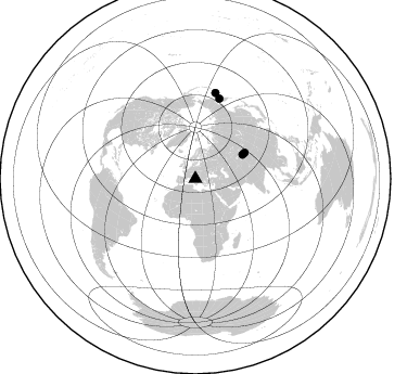
Station YR ED07 - TORNELLA
Network: YR16 - Armatrice Sequence International
Nearby stations (2 deg radius)
| Station | Name | (Lat, Lon) | Start / End | Elevation |
| ED07 | TORNELLA | (42.63, 13.47) | 2016-08-30 / 2017-12-16 | 1025 m |
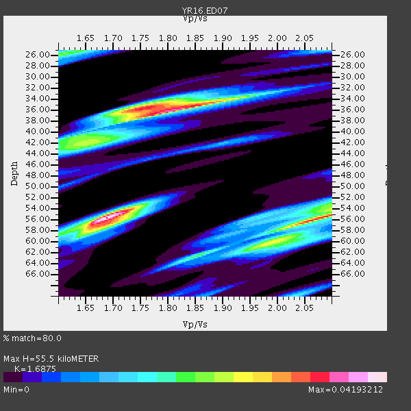
| Crust2 Type: | M5,extended crust, 0.5 km seds. |
| Thickness Estimate: | 56 km |
| Thickness StdDev: | 11 km |
| Vp/Vs Estimate: | 1.69 |
| Vp/Vs StdDev: | 0.14 |
| Vs Estimate: | 3.719 km/s |
| Poisson's Ratio: | 0.23 |
| Peak Value: | 0.04 |
| Assumed Vp: | 6.276 km/s |
| Ps Weight: | 0.33333334 |
| PpPs Weight: | 0.33333334 |
| PsPs Weight: | 0.33333328 |
| Residual Complexity: | 0.889 |
| Nearby stations H: | +- |
| (2.0 deg) Vp/Vs: | +- |
0 with match > 90% ( 0.0 %) and 4 with match > 80% ( 8.163265 %) out of 49.
Download stack as xyz text file.
Azimuth Distribution of Events:
Prior Results for this Station
| Study | Thickness | Vp/Vs | Vp | Vs | Poissons Ratio | Extra |
| EARS | 56 km | 1.69 | 6.276 km/s | 3.719 km/s | 0.23 | |
| Crust2.0 | 31 km | 1.78 | 6.276 km/s | 3.529 km/s | 0.27 | M5,extended crust, 0.5 km seds. |
| Global Maxima | 56 km | 1.69 | 6.276 km/s | 3.719 km/s | 0.23 | amp=0.04193212 |
| Local Maxima 1 | 36 km | 1.81 | 6.276 km/s | 3.477 km/s | 0.28 | amp=0.03680801 |
| Local Maxima 2 | 56 km | 2.08 | 6.276 km/s | 3.021 km/s | 0.35 | amp=0.035626076 |
| Local Maxima 3 | 36 km | 1.75 | 6.276 km/s | 3.591 km/s | 0.26 | amp=0.027635364 |
| Local Maxima 4 | 60 km | 1.98 | 6.276 km/s | 3.174 km/s | 0.33 | amp=0.02207246 |
| Predicted Arrivals for vertical incidence (zero ray parameter) | |
| Ps | 6.08 SECOND |
| PpPs | 23.77 SECOND |
| PsPs/PpSs | 29.85 SECOND |
Events Processed for this Station
Download zip of receiver functions as SAC
Plot maxima for each earthquake.
Events Used in the Stack
(4 events)| Radial Match | Distance | Baz | FERegion | Time | Lat/Lon | Depth | Magnitude |
| 87.066956 | 81.8 deg | 13.217 deg | Near Islands, Aleutian Islands | 2017/06/02 22:24:47 GMT | (54.0, 170.9) | 8.2 km | 6.8 Mww |
| 86.79098 | 77.5 deg | 16.68 deg | Near East Coast Of Kamchatka | 2017/03/29 04:09:24 GMT | (56.9, 162.7) | 23 km | 6.6 Mww |
| 83.49049 | 49.0 deg | 62.954 deg | Northern Xinjiang, China | 2017/08/08 23:27:53 GMT | (44.3, 82.8) | 20 km | 6.3 Mww |
| 82.37624 | 51.5 deg | 62.175 deg | Northern Xinjiang, China | 2016/12/08 05:15:04 GMT | (43.8, 86.3) | 14 km | 5.9 Mwp |
Losers
(45 events)| Radial Match | Distance | Baz | FERegion | Time | Lat/Lon | Depth | Magnitude | Reason |
| 96.33612 | 62.8 deg | 69.301 deg | Xizang | 2016/10/17 07:14:50 GMT | (32.9, 94.9) | 32 km | 6.4 MO | |
| 87.722885 | 85.8 deg | 7.541 deg | Andreanof Islands, Aleutian Is. | 2017/05/08 17:00:42 GMT | (51.4, -178.6) | 1.0 km | 6.6 Mi | |
| 81.766785 | 81.7 deg | 22.216 deg | Kuril Islands | 2017/06/03 11:47:23 GMT | (50.9, 157.3) | 44 km | 5.1 Mww | |
| 79.06021 | 90.9 deg | 287.017 deg | Off Coast Of Central America | 2016/11/24 18:43:48 GMT | (12.0, -88.8) | 10 km | 7.0 MWW, 6.7 MWB, 7.2 MI | |
| 78.68282 | 91.0 deg | 291.26 deg | Near Coast Of Chiapas, Mexico | 2017/06/14 07:29:03 GMT | (14.9, -92.0) | 98 km | 7.0 Mi | |
| 78.581474 | 65.8 deg | 168.171 deg | Botswana | 2017/04/03 17:40:18 GMT | (-22.7, 25.1) | 29 km | 6.5 Mww | |
| 78.43002 | 81.9 deg | 92.465 deg | Off W Coast Of Northern Sumatra | 2017/03/14 13:13:38 GMT | (3.6, 95.9) | 41 km | 5.5 mb | |
| 77.90269 | 83.2 deg | 12.814 deg | Near Islands, Aleutian Islands | 2017/03/27 10:50:19 GMT | (52.8, 172.2) | 10 km | 6.1 Mww | |
| 77.63265 | 61.1 deg | 261.454 deg | North Atlantic Ocean | 2017/07/27 17:53:25 GMT | (13.4, -49.4) | 10 km | 5.9 Mww | |
| 75.816696 | 92.5 deg | 93.674 deg | Southern Sumatra, Indonesia | 2016/09/17 02:30:57 GMT | (-4.4, 102.8) | 60 km | 5.5 MB | |
| 74.25316 | 74.9 deg | 344.869 deg | Southeastern Alaska | 2017/05/01 12:31:53 GMT | (59.9, -136.6) | 0.1 km | 6.5 Ml | |
| 74.15847 | 44.2 deg | 96.767 deg | Southwestern Pakistan | 2017/02/07 22:03:55 GMT | (25.2, 63.3) | 24 km | 6.3 Mww | |
| 73.53167 | 84.0 deg | 11.769 deg | Near Islands, Aleutian Islands | 2016/12/03 09:23:34 GMT | (52.2, 174.2) | 27 km | 6.0 mb | |
| 72.94842 | 43.1 deg | 73.821 deg | Tajikistan | 2017/05/05 05:09:35 GMT | (39.5, 71.4) | 10 km | 5.8 Mww | |
| 72.79015 | 36.6 deg | 84.664 deg | Northern And Central Iran | 2017/04/05 06:09:12 GMT | (35.8, 60.4) | 13 km | 6.1 Mww | |
| 72.70051 | 54.9 deg | 243.981 deg | Central Mid-Atlantic Ridge | 2016/10/05 20:53:39 GMT | (7.1, -34.3) | 10 km | 5.5 mwb | |
| 71.96402 | 68.9 deg | 271.464 deg | Leeward Islands | 2016/10/18 22:08:14 GMT | (15.2, -61.5) | 143 km | 5.6 MWW, 5.6 MWB | |
| 71.41873 | 91.2 deg | 289.797 deg | Near Coast Of Guatemala | 2017/06/22 12:31:04 GMT | (13.7, -91.1) | 10 km | 6.8 Mi | |
| 70.745384 | 84.1 deg | 358.049 deg | Unimak Island Region, Alaska | 2016/10/27 11:53:18 GMT | (53.6, -163.3) | 17 km | 5.8 MWP, 5.8 MI | |
| 70.73943 | 87.3 deg | 332.318 deg | Off Coast Of Oregon | 2016/11/28 04:34:44 GMT | (43.4, -127.0) | 28 km | 5.5 MWW, 5.4 MWR | |
| 70.338524 | 94.1 deg | 311.187 deg | Gulf Of California | 2017/03/29 15:15:26 GMT | (26.0, -110.0) | 10 km | 5.7 Mww | |
| 70.02071 | 89.6 deg | 330.38 deg | Off Coast Of Northern California | 2016/12/08 14:49:46 GMT | (40.5, -126.2) | 12 km | 6.5 Mwb | |
| 69.64123 | 80.9 deg | 14.328 deg | Komandorskiye Ostrova Region | 2017/07/17 11:05:08 GMT | (54.6, 168.6) | 7.9 km | 6.2 Mww | |
| 68.644646 | 86.8 deg | 42.353 deg | Eastern Honshu, Japan | 2017/06/24 22:02:16 GMT | (35.8, 137.6) | 10 km | 5.2 Mww | |
| 68.15798 | 94.0 deg | 247.504 deg | Southern Bolivia | 2017/02/21 14:09:04 GMT | (-19.3, -63.9) | 598 km | 6.5 Mww | |
| 65.60919 | 91.8 deg | 272.63 deg | Near Coast Of Ecuador | 2017/01/31 14:22:40 GMT | (0.7, -79.7) | 21 km | 5.5 Mww | |
| 65.5701 | 41.3 deg | 275.399 deg | Northern Mid-Atlantic Ridge | 2017/06/30 01:34:58 GMT | (33.7, -38.5) | 10 km | 5.8 Mwb | |
| 65.526 | 87.3 deg | 39.875 deg | Near East Coast Of Honshu, Japan | 2016/12/28 12:38:50 GMT | (36.9, 140.4) | 10 km | 5.9 Mww | |
| 65.376915 | 31.9 deg | 304.403 deg | Reykjanes Ridge | 2017/03/31 17:25:23 GMT | (52.7, -32.3) | 10 km | 5.5 Mww | |
| 63.901398 | 77.7 deg | 93.019 deg | Nicobar Islands, India Region | 2017/03/14 02:51:16 GMT | (6.1, 92.3) | 10 km | 6.0 Mww | |
| 63.511677 | 79.9 deg | 42.782 deg | Sea Of Japan | 2017/07/12 19:48:07 GMT | (40.9, 131.6) | 538 km | 5.8 Mww | |
| 63.080963 | 89.8 deg | 285.083 deg | Near Coast Of Nicaragua | 2017/06/17 13:47:38 GMT | (11.3, -86.7) | 28 km | 5.4 Mww | |
| 61.524696 | 89.0 deg | 57.16 deg | Ryukyu Islands, Japan | 2017/05/09 01:54:14 GMT | (24.4, 126.3) | 10 km | 6.0 Mww | |
| 59.484913 | 46.4 deg | 154.635 deg | Lake Victoria Region | 2016/09/10 12:27:28 GMT | (-1.0, 31.5) | 10 km | 5.9 MWW, 5.8 MWB, 5.9 MWC | |
| 58.722424 | 86.2 deg | 6.606 deg | Andreanof Islands, Aleutian Is. | 2017/05/08 15:31:28 GMT | (51.1, -177.0) | 41 km | 5.5 Ml | |
| 58.035976 | 75.0 deg | 344.888 deg | Southeastern Alaska | 2017/05/01 14:18:15 GMT | (59.8, -136.6) | 3.3 km | 6.3 Ml | |
| 57.722317 | 66.0 deg | 78.883 deg | India-Bangladesh Border Region | 2017/01/03 09:09:02 GMT | (24.0, 92.0) | 36 km | 5.5 mb | |
| 57.2172 | 84.6 deg | 31.322 deg | Kuril Islands | 2017/05/22 11:00:57 GMT | (43.9, 147.7) | 54 km | 5.5 Mww | |
| 56.953125 | 86.3 deg | 6.66 deg | Andreanof Islands, Aleutian Is. | 2017/05/08 15:47:28 GMT | (51.0, -177.1) | 1.0 km | 5.7 Mi | |
| 54.9962 | 92.6 deg | 258.95 deg | Peru-Brazil Border Region | 2016/12/18 13:30:11 GMT | (-10.0, -71.0) | 619 km | 6.4 Mww | |
| 54.47525 | 84.7 deg | 31.02 deg | East Of Kuril Islands | 2016/10/23 20:25:26 GMT | (44.0, 148.2) | 30 km | 5.8 MB | |
| 53.555443 | 59.6 deg | 211.466 deg | Ascension Island Region | 2017/05/02 15:10:22 GMT | (-11.7, -13.9) | 10 km | 5.6 mb | |
| 50.44215 | 83.8 deg | 28.165 deg | Kuril Islands | 2017/07/30 21:00:49 GMT | (46.2, 151.0) | 87 km | 5.7 mb | |
| 44.08535 | 88.5 deg | 324.488 deg | California-Nevada Border Region | 2016/12/28 08:22:12 GMT | (38.4, -118.9) | 12 km | 5.7 ml | |
| 37.82578 | 87.4 deg | 38.822 deg | Near East Coast Of Honshu, Japan | 2017/07/20 00:11:25 GMT | (37.4, 141.6) | 35 km | 5.8 Mww |

