
Station YR ED14 - VASTO
Network: YR16 - Armatrice Sequence International
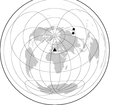
Nearby stations (2 deg radius)
| Station | Name | (Lat, Lon) | Start / End | Elevation |
| ED14 | VASTO | (42.44, 13.43) | 2016-08-30 / 2017-12-16 | 1230 m |
| Crust2 Type: | M5,extended crust, 0.5 km seds. |
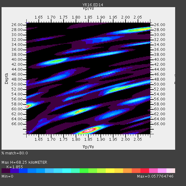
| Thickness Estimate: | 68 km |
| Thickness StdDev: | 18 km |
| Vp/Vs Estimate: | 1.86 |
| Vp/Vs StdDev: | 0.18 |
| Vs Estimate: | 3.383 km/s |
| Poisson's Ratio: | 0.30 |
| Peak Value: | 0.06 |
| Assumed Vp: | 6.276 km/s |
| Ps Weight: | 0.33333334 |
| PpPs Weight: | 0.33333334 |
| PsPs Weight: | 0.33333328 |
| Residual Complexity: | 0.818 |
| Nearby stations H: | +- |
| (2.0 deg) Vp/Vs: | +- |
0 with match > 90% ( 0.0 %) and 2 with match > 80% ( 13.333333 %) out of 15.
Download stack as xyz text file.
Azimuth Distribution of Events:
Prior Results for this Station
| Study | Thickness | Vp/Vs | Vp | Vs | Poissons Ratio | Extra |
| EARS | 68 km | 1.86 | 6.276 km/s | 3.383 km/s | 0.30 | |
| Crust2.0 | 31 km | 1.78 | 6.276 km/s | 3.529 km/s | 0.27 | M5,extended crust, 0.5 km seds. |
| Global Maxima | 68 km | 1.86 | 6.276 km/s | 3.383 km/s | 0.30 | amp=0.057764746 |
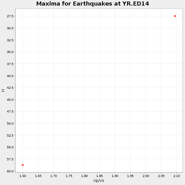
| Local Maxima 1 | 59 km | 1.60 | 6.276 km/s | 3.922 km/s | 0.18 | amp=0.055263 |
| Local Maxima 2 | 61 km | 1.81 | 6.276 km/s | 3.472 km/s | 0.28 | amp=0.04479978 |
| Local Maxima 3 | 28 km | 2.09 | 6.276 km/s | 3.01 km/s | 0.35 | amp=0.038647044 |
| Local Maxima 4 | 40 km | 1.72 | 6.276 km/s | 3.643 km/s | 0.25 | amp=0.028233169 |
| Predicted Arrivals for vertical incidence (zero ray parameter) | |
| Ps | 9.30 SECOND |
| PpPs | 31.05 SECOND |
| PsPs/PpSs | 40.35 SECOND |
Events Processed for this Station
Download zip of receiver functions as SAC
Plot maxima for each earthquake.
Events Used in the Stack
(2 events)| Radial Match | Distance | Baz | FERegion | Time | Lat/Lon | Depth | Magnitude |
| 83.90225 | 82.6 deg | 47.595 deg | South Korea | 2016/09/12 11:32:55 GMT | (35.8, 129.2) | 13 km | 5.4 Mww |
| 83.59715 | 93.4 deg | 42.456 deg | Southeast Of Honshu, Japan | 2016/09/20 16:21:16 GMT | (30.5, 142.1) | 10 km | 6.1 MWW, 6.0 MWB |
Losers
(13 events)| Radial Match | Distance | Baz | FERegion | Time | Lat/Lon | Depth | Magnitude | Reason |
| 84.95232 | 88.3 deg | 53.588 deg | Ryukyu Islands, Japan | 2016/09/26 05:19:58 GMT | (27.5, 128.6) | 40 km | 6.0 MB | |
| 83.10325 | 90.0 deg | 40.393 deg | Off East Coast Of Honshu, Japan | 2016/09/23 00:14:33 GMT | (34.5, 141.7) | 10 km | 6.4 MWP, 6.3 MWW | |
| 81.953804 | 87.4 deg | 61.599 deg | Taiwan Region | 2016/10/06 15:52:00 GMT | (22.6, 121.4) | 17 km | 5.7 MO | |
| 74.38755 | 85.3 deg | 45.039 deg | Western Honshu, Japan | 2016/10/21 05:07:23 GMT | (35.4, 133.8) | 10 km | 6.2 MWW, 6.6 MI | |
| 72.15342 | 62.9 deg | 69.195 deg | Xizang | 2016/10/17 07:14:50 GMT | (32.9, 94.9) | 32 km | 6.4 MO | |
| 68.93842 | 57.8 deg | 258.075 deg | Northern Mid-Atlantic Ridge | 2016/10/20 00:09:26 GMT | (13.3, -44.9) | 10 km | 5.7 MWP | |
| 67.73724 | 46.3 deg | 154.518 deg | Lake Victoria Region | 2016/09/10 12:27:28 GMT | (-1.0, 31.5) | 10 km | 5.9 MWW, 5.8 MWB, 5.9 MWC | |
| 65.074425 | 95.5 deg | 44.08 deg | Bonin Islands, Japan Region | 2016/10/04 14:00:46 GMT | (27.9, 142.0) | 30 km | 5.6 MO | |
| 64.61797 | 86.0 deg | 92.872 deg | Northern Sumatra, Indonesia | 2016/09/01 20:04:15 GMT | (0.6, 98.5) | 24 km | 5.8 MB | |
| 60.410583 | 68.8 deg | 271.513 deg | Leeward Islands | 2016/10/18 22:08:14 GMT | (15.2, -61.5) | 143 km | 5.6 MWW, 5.6 MWB | |
| 58.19324 | 83.6 deg | 139.529 deg | Southwest Indian Ridge | 2016/09/16 18:38:05 GMT | (-29.1, 60.9) | 10 km | 5.5 MB, 5.4 MWB, 5.5 MWC | |
| 56.086906 | 84.8 deg | 275.09 deg | Northern Colombia | 2016/09/14 01:58:30 GMT | (7.3, -76.1) | 10 km | 5.9 MWP | |
| 39.82368 | 53.0 deg | 267.024 deg | Northern Mid-Atlantic Ridge | 2016/09/09 17:17:54 GMT | (22.1, -45.9) | 10 km | 5.5 MB |

