
Station YS GPSS1 - Grants Pass single station
Network: YS01 - Grants Pass Well
Nearby stations (2 deg radius)
| Station | Name | (Lat, Lon) | Start / End | Elevation |
| GPSS1 | Grants Pass single station | (42.50, -123.37) | 2001-12-20 / 2003-02-24 | 800 m |
| Crust2 Type: | LC,continental arc, Cordilleras, 1.0 km seds. |
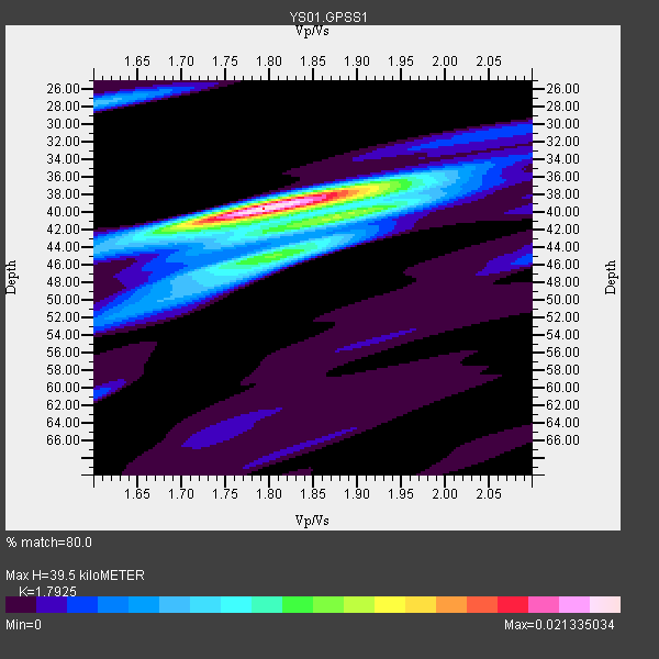
| Thickness Estimate: | 40 km |
| Thickness StdDev: | 1.3 km |
| Vp/Vs Estimate: | 1.79 |
| Vp/Vs StdDev: | 0.05 |
| Vs Estimate: | 3.638 km/s |
| Poisson's Ratio: | 0.27 |
| Peak Value: | 0.02 |
| Assumed Vp: | 6.522 km/s |
| Ps Weight: | 0.33333334 |
| PpPs Weight: | 0.33333334 |
| PsPs Weight: | 0.33333328 |
| Residual Complexity: | 0.575 |
| Nearby stations H: | +- |
| (2.0 deg) Vp/Vs: | +- |
11 with match > 90% ( 61.11111 %) and 18 with match > 80% ( 100.0 %) out of 18.
Download stack as xyz text file.
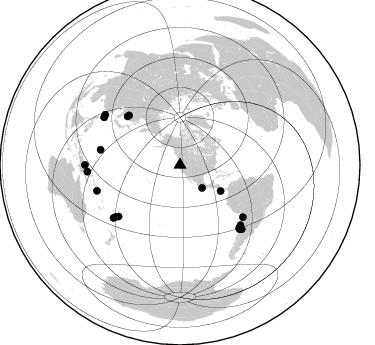
Azimuth Distribution of Events:
Prior Results for this Station
| Study | Thickness | Vp/Vs | Vp | Vs | Poissons Ratio | Extra |
| EARS | 40 km | 1.79 | 6.522 km/s | 3.638 km/s | 0.27 | |
| Crust2.0 | 37 km | 1.77 | 6.522 km/s | 3.676 km/s | 0.27 | LC,continental arc, Cordilleras, 1.0 km seds. |
| Global Maxima | 40 km | 1.79 | 6.522 km/s | 3.638 km/s | 0.27 | amp=0.021335034 |
| Local Maxima 1 | 40 km | 1.89 | 6.522 km/s | 3.446 km/s | 0.31 | amp=0.011495279 |
| Local Maxima 2 | 45 km | 1.80 | 6.522 km/s | 3.628 km/s | 0.28 | amp=0.008304598 |
| Local Maxima 3 | 28 km | 1.60 | 6.522 km/s | 4.07 km/s | 0.18 | amp=0.0059055737 |
| Local Maxima 4 | 37 km | 1.89 | 6.522 km/s | 3.455 km/s | 0.30 | amp=0.00502369 |
| Predicted Arrivals for vertical incidence (zero ray parameter) | |
| Ps | 4.80 SECOND |
| PpPs | 16.91 SECOND |
| PsPs/PpSs | 21.71 SECOND |
Events Processed for this Station
Download zip of receiver functions as SAC
Plot maxima for each earthquake.
Events Used in the Stack
(18 events)| Radial Match | Distance | Baz | FERegion | Time | Lat/Lon | Depth | Magnitude |
| 99.975365 | 80.0 deg | 230.123 deg | Fiji Islands Region | 2002/07/05 06:15:28 GMT | (-20.6, -177.2) | 280 km | 5.7 MW, 5.2 MB |
| 99.94883 | 92.8 deg | 265.826 deg | Eastern New Guinea Reg., P.N.G. | 2002/07/03 23:00:18 GMT | (-5.0, 147.3) | 31 km | 5.6 MB, 6.2 MS, 6.2 MW, 6.2 MW |
| 96.639725 | 86.8 deg | 252.784 deg | Solomon Islands | 2003/01/20 08:43:06 GMT | (-10.5, 160.8) | 33 km | 6.7 MB, 7.8 MS, 7.3 MW, 7.2 MW |
| 95.32492 | 87.3 deg | 137.076 deg | Near Coast Of Central Chile | 2002/06/18 13:56:22 GMT | (-30.8, -71.1) | 54 km | 6.0 MB, 6.6 MW, 6.4 MW |
| 94.30353 | 48.2 deg | 122.668 deg | Costa Rica | 2002/06/16 02:46:14 GMT | (8.8, -84.0) | 35 km | 5.4 MB, 6.2 MS, 6.4 MW, 6.4 MW |
| 93.45344 | 89.7 deg | 301.908 deg | Southwestern Ryukyu Isl., Japan | 2002/03/26 03:45:48 GMT | (23.3, 124.1) | 33 km | 5.8 MB, 6.6 MS, 6.4 MW, 6.4 MW |
| 93.42083 | 94.9 deg | 270.051 deg | Near N Coast Of New Guinea, P.N.G. | 2002/09/08 18:44:23 GMT | (-3.3, 142.9) | 13 km | 6.5 MB, 7.8 MS, 7.6 MW, 7.3 MW |
| 92.45229 | 82.2 deg | 231.217 deg | Fiji Islands Region | 2002/08/19 11:01:01 GMT | (-21.7, -179.5) | 580 km | 6.7 MB, 7.6 MW, 7.7 ME |
| 91.89821 | 81.5 deg | 129.578 deg | Chile-Bolivia Border Region | 2002/03/28 04:56:22 GMT | (-21.7, -68.3) | 125 km | 6.1 MB, 6.5 MW, 6.5 MW |
| 91.43186 | 90.2 deg | 303.824 deg | Taiwan Region | 2002/03/31 06:52:50 GMT | (24.3, 122.2) | 33 km | 6.4 MB, 7.4 MS, 7.1 MW, 7.1 MW |
| 90.0607 | 84.8 deg | 231.457 deg | South Of Fiji Islands | 2002/08/19 11:03:13 GMT | (-23.6, 178.5) | 650 km | 5.9 MB |
| 88.29606 | 86.3 deg | 136.596 deg | Near Coast Of Central Chile | 2002/04/01 19:59:32 GMT | (-29.7, -71.4) | 71 km | 6.1 MB, 6.4 MW, 6.4 MW |
| 84.58363 | 88.9 deg | 136.169 deg | San Juan Province, Argentina | 2002/09/24 03:57:22 GMT | (-31.5, -69.2) | 120 km | 6.2 MB, 6.4 MW, 6.3 MW |
| 84.21713 | 80.9 deg | 280.736 deg | Mariana Islands | 2002/08/14 13:57:52 GMT | (14.1, 146.2) | 30 km | 6.1 MB, 6.4 MS, 6.5 MW, 6.4 MW |
| 83.08226 | 85.0 deg | 134.773 deg | Near Coast Of Northern Chile | 2002/04/18 16:08:36 GMT | (-27.5, -70.6) | 62 km | 6.2 MB, 6.7 MW, 6.6 MW |
| 82.507965 | 71.2 deg | 313.966 deg | Northeastern China | 2002/09/15 08:39:32 GMT | (44.8, 129.9) | 586 km | 5.8 MB, 6.4 MW, 6.4 MW |
| 82.06566 | 71.6 deg | 312.739 deg | E. Russia-N.E. China Border Reg. | 2002/06/28 17:19:30 GMT | (43.8, 130.7) | 566 km | 6.7 MB, 7.3 MW, 7.3 MW |
| 81.4935 | 31.9 deg | 136.081 deg | Near Coast Of Guerrero, Mexico | 2002/04/18 05:02:46 GMT | (17.0, -100.9) | 25 km | 5.4 MB, 6.0 MS, 6.3 MW, 6.1 MW |
Losers
(0 events)| Radial Match | Distance | Baz | FERegion | Time | Lat/Lon | Depth | Magnitude | Reason |
