
Station YS PL55 - WHOI OBS ID S34
Network: YS04 - Plume Lithosphere Undersea Melt Experiment
Nearby stations (2 deg radius)
| Station | Name | (Lat, Lon) | Start / End | Elevation |
| PL55 | WHOI OBS ID S34 | (18.30, -152.98) | 2006-04-28 / 2007-05-25 | -5076.0 m |
| Crust2 Type: | A0,normal oceanic, 0.07 km seds. |
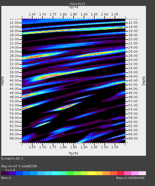
| Thickness Estimate: | 48 km |
| Thickness StdDev: | 16 km |
| Vp/Vs Estimate: | 1.60 |
| Vp/Vs StdDev: | 0.22 |
| Vs Estimate: | 2.65 km/s |
| Poisson's Ratio: | 0.18 |
| Peak Value: | 0.41 |
| Assumed Vp: | 4.24 km/s |
| Ps Weight: | 0.33333334 |
| PpPs Weight: | 0.33333334 |
| PsPs Weight: | 0.33333328 |
| Residual Complexity: | 0.918 |
| Nearby stations H: | +- |
| (2.0 deg) Vp/Vs: | +- |
0 with match > 90% ( 0.0 %) and 2 with match > 80% ( 7.4074073 %) out of 27.
Download stack as xyz text file.
Azimuth Distribution of Events:

Prior Results for this Station
| Study | Thickness | Vp/Vs | Vp | Vs | Poissons Ratio | Extra |
| EARS | 48 km | 1.60 | 4.24 km/s | 2.65 km/s | 0.18 | |
| Crust2.0 | 12 km | 2.19 | 4.24 km/s | 1.94 km/s | 0.37 | A0,normal oceanic, 0.07 km seds. |
| Global Maxima | 48 km | 1.60 | 4.24 km/s | 2.65 km/s | 0.18 | amp=0.40990946 |
| Local Maxima 1 | 52 km | 1.82 | 4.24 km/s | 2.336 km/s | 0.28 | amp=0.38269934 |
| Local Maxima 2 | 53 km | 1.61 | 4.24 km/s | 2.642 km/s | 0.18 | amp=0.3634996 |
| Local Maxima 3 | 28 km | 1.66 | 4.24 km/s | 2.558 km/s | 0.21 | amp=0.3490737 |
| Local Maxima 4 | 14 km | 2.09 | 4.24 km/s | 2.029 km/s | 0.35 | amp=0.3399632 |
| Predicted Arrivals for vertical incidence (zero ray parameter) | |
| Ps | 6.72 SECOND |
| PpPs | 29.13 SECOND |
| PsPs/PpSs | 35.85 SECOND |
Events Processed for this Station
Download zip of receiver functions as SAC
Plot maxima for each earthquake.
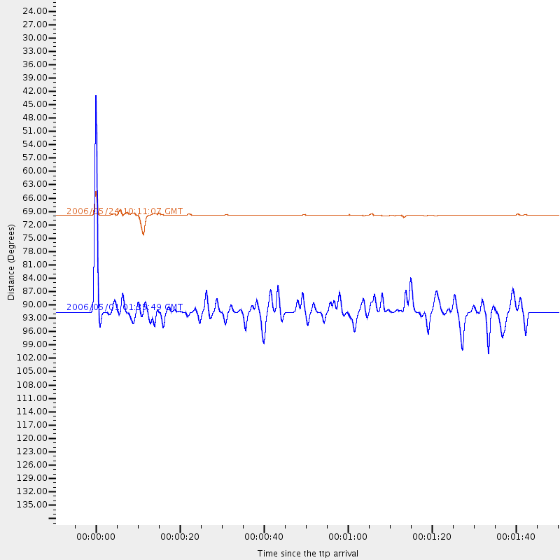
Events Used in the Stack
(2 events)| Radial Match | Distance | Baz | FERegion | Time | Lat/Lon | Depth | Magnitude |
| 89.02444 | 69.8 deg | 260.524 deg | Near North Coast Of Irian Jaya | 2006/05/24 10:11:07 GMT | (-2.2, 139.2) | 32 km | 5.8 MB, 5.6 MS, 5.7 MW, 5.7 MW |
| 85.5771 | 91.2 deg | 118.197 deg | Near Coast Of Northern Chile | 2006/05/01 01:35:49 GMT | (-27.3, -71.2) | 16 km | 5.5 ML |
Losers
(25 events)| Radial Match | Distance | Baz | FERegion | Time | Lat/Lon | Depth | Magnitude | Reason |
| 99.91084 | 43.5 deg | 210.36 deg | Tonga Islands | 2006/05/05 06:16:20 GMT | (-19.8, -174.7) | 35 km | 5.6 MB, 5.8 MS, 5.9 MW, 5.8 MW | |
| 99.01156 | 43.6 deg | 209.873 deg | Tonga Islands | 2006/05/07 02:33:47 GMT | (-20.1, -174.4) | 41 km | 5.6 MW | |
| 98.96464 | 43.8 deg | 209.095 deg | Tonga Islands | 2006/05/04 11:25:26 GMT | (-20.6, -174.0) | 11 km | 5.7 MB, 5.8 MS, 6.0 MW, 5.8 MW | |
| 96.96412 | 68.7 deg | 88.273 deg | Panama-Costa Rica Border Region | 2006/05/01 09:13:31 GMT | (8.1, -82.9) | 10 km | 5.5 MW, 5.0 MS, 5.2 MB, 5.0 ML | |
| 90.92798 | 43.5 deg | 210.17 deg | Tonga Islands | 2006/05/28 03:36:18 GMT | (-19.9, -174.5) | 49 km | 5.8 MB, 5.6 MW | |
| 85.75472 | 51.2 deg | 232.141 deg | Vanuatu Islands | 2006/04/30 08:17:34 GMT | (-15.1, 167.4) | 128 km | 5.4 MB, 6.1 MW, 6.1 MW | |
| 74.28554 | 43.5 deg | 209.477 deg | Tonga Islands | 2006/05/03 15:26:40 GMT | (-20.2, -174.1) | 55 km | 7.2 MB, 7.8 MS, 7.9 MW, 7.9 MW | |
| 71.452385 | 92.2 deg | 259.002 deg | South Of Sumbawa, Indonesia | 2006/04/29 04:06:13 GMT | (-11.2, 118.3) | 23 km | 5.8 MW, 5.7 MW, 5.9 MB | |
| 57.795395 | 55.8 deg | 207.166 deg | Kermadec Islands Region | 2006/05/16 10:39:23 GMT | (-31.8, -179.3) | 152 km | 6.8 MB, 7.4 MW, 7.4 MW | |
| 53.439133 | 51.9 deg | 206.922 deg | Kermadec Islands Region | 2006/05/01 02:24:41 GMT | (-28.5, -176.9) | 37 km | 5.7 MS, 5.3 MB, 5.7 MW | |
| 49.93217 | 60.0 deg | 251.96 deg | New Britain Region, P.N.G. | 2006/05/28 03:12:08 GMT | (-5.7, 151.1) | 34 km | 5.9 MB, 6.6 MS, 6.5 MW, 6.4 MW | |
| 49.598774 | 51.8 deg | 207.097 deg | Kermadec Islands Region | 2006/05/01 02:25:41 GMT | (-28.3, -176.9) | 35 km | 5.7 MW | |
| 47.55551 | 39.0 deg | 211.781 deg | Tonga Islands | 2006/04/30 19:33:18 GMT | (-15.5, -173.1) | 10 km | 5.8 MB, 5.9 MS, 5.9 MW | |
| 44.995335 | 41.0 deg | 331.943 deg | Rat Islands, Aleutian Islands | 2006/06/14 04:46:42 GMT | (51.9, 177.1) | 29 km | 5.5 MB, 5.9 MW, 5.7 ML | |
| 42.00375 | 43.7 deg | 216.889 deg | Fiji Islands Region | 2006/06/09 05:58:27 GMT | (-17.5, -178.7) | 564 km | 5.3 MB, 6.1 MW, 6.1 MW | |
| 39.72622 | 40.9 deg | 331.696 deg | Rat Islands, Aleutian Islands | 2006/06/14 04:18:42 GMT | (51.8, 177.1) | 14 km | 5.9 MB, 6.4 MS, 6.4 MW, 6.4 MW | |
| 38.019917 | 51.5 deg | 335.615 deg | Eastern Siberia, Russia | 2006/05/09 11:02:22 GMT | (60.8, 165.9) | 10 km | 5.6 MB, 5.5 MS, 5.8 MW, 5.7 MW | |
| 36.43766 | 53.6 deg | 225.924 deg | Loyalty Islands | 2006/05/24 09:45:34 GMT | (-20.4, 168.9) | 40 km | 5.5 MW | |
| 34.28456 | 57.9 deg | 247.874 deg | Solomon Islands | 2006/05/29 12:12:13 GMT | (-7.9, 154.6) | 27 km | 5.5 MW | |
| 30.679874 | 36.4 deg | 343.245 deg | Fox Islands, Aleutian Islands | 2006/05/10 02:42:51 GMT | (52.5, -169.3) | 18 km | 6.1 MB, 6.2 MS, 6.4 MW, 6.3 MW | |
| 29.731972 | 44.0 deg | 209.108 deg | Tonga Islands | 2006/05/16 20:55:47 GMT | (-20.8, -174.2) | 15 km | 5.8 MB, 5.6 MS, 5.7 MW | |
| 28.076021 | 55.2 deg | 100.33 deg | West Of Galapagos Islands | 2006/05/01 20:13:28 GMT | (2.2, -99.0) | 10 km | 5.7 MW, 5.0 MB, 5.7 MW | |
| 27.641962 | 51.6 deg | 325.852 deg | Kamchatka Peninsula, Russia | 2006/05/22 13:08:01 GMT | (54.3, 158.4) | 185 km | 6.2 MB, 6.2 MW, 6.2 MW | |
| 16.89176 | 82.2 deg | 262.432 deg | Banda Sea | 2006/05/22 20:53:57 GMT | (-4.7, 126.8) | 2.8 km | 5.8 MB, 5.9 MS, 6.1 MW, 6.1 MW | |
| 10.593982 | 69.5 deg | 258.675 deg | Irian Jaya, Indonesia | 2006/05/30 03:28:52 GMT | (-3.8, 140.1) | 30 km | 5.5 MB, 5.7 MS, 5.9 MW, 5.9 MW |
