
Station YS PL57 - WHOI OBS ID S25
Network: YS04 - Plume Lithosphere Undersea Melt Experiment
Nearby stations (2 deg radius)
| Station | Name | (Lat, Lon) | Start / End | Elevation |
| PL57 | WHOI OBS ID S25 | (18.91, -150.91) | 2006-04-29 / 2007-12-13 | -5335.0 m |
| Crust2 Type: | A0,normal oceanic, 0.07 km seds. |
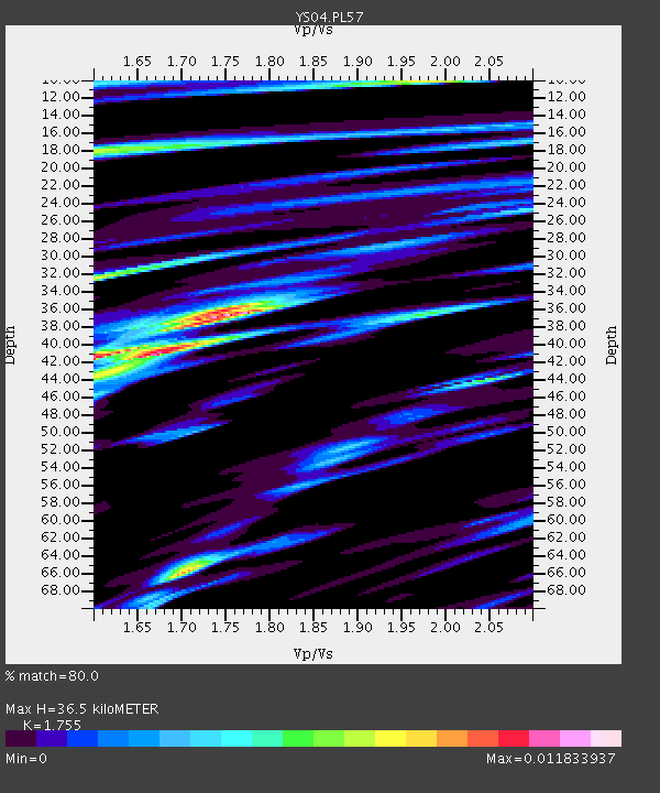
| Thickness Estimate: | 36 km |
| Thickness StdDev: | 13 km |
| Vp/Vs Estimate: | 1.75 |
| Vp/Vs StdDev: | 0.12 |
| Vs Estimate: | 2.416 km/s |
| Poisson's Ratio: | 0.26 |
| Peak Value: | 0.01 |
| Assumed Vp: | 4.24 km/s |
| Ps Weight: | 0.33333334 |
| PpPs Weight: | 0.33333334 |
| PsPs Weight: | 0.33333328 |
| Residual Complexity: | 0.801 |
| Nearby stations H: | +- |
| (2.0 deg) Vp/Vs: | +- |
3 with match > 90% ( 23.076923 %) and 3 with match > 80% ( 23.076923 %) out of 13.
Download stack as xyz text file.
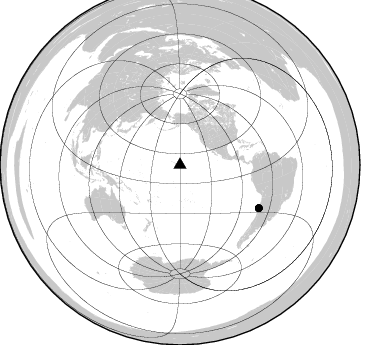
Azimuth Distribution of Events:
Prior Results for this Station
| Study | Thickness | Vp/Vs | Vp | Vs | Poissons Ratio | Extra |
| EARS | 36 km | 1.75 | 4.24 km/s | 2.416 km/s | 0.26 | |
| Crust2.0 | 12 km | 2.19 | 4.24 km/s | 1.94 km/s | 0.37 | A0,normal oceanic, 0.07 km seds. |
| Global Maxima | 36 km | 1.75 | 4.24 km/s | 2.416 km/s | 0.26 | amp=0.011833937 |
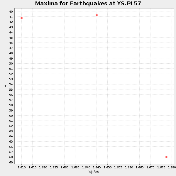
| Local Maxima 1 | 41 km | 1.63 | 4.24 km/s | 2.601 km/s | 0.20 | amp=0.010718161 |
| Local Maxima 2 | 66 km | 1.70 | 4.24 km/s | 2.49 km/s | 0.24 | amp=0.008823245 |
| Local Maxima 3 | 32 km | 1.61 | 4.24 km/s | 2.642 km/s | 0.18 | amp=0.007317633 |
| Local Maxima 4 | 10 km | 1.98 | 4.24 km/s | 2.141 km/s | 0.33 | amp=0.0072946143 |
| Predicted Arrivals for vertical incidence (zero ray parameter) | |
| Ps | 6.50 SECOND |
| PpPs | 23.72 SECOND |
| PsPs/PpSs | 30.22 SECOND |
Events Processed for this Station
Download zip of receiver functions as SAC
Plot maxima for each earthquake.
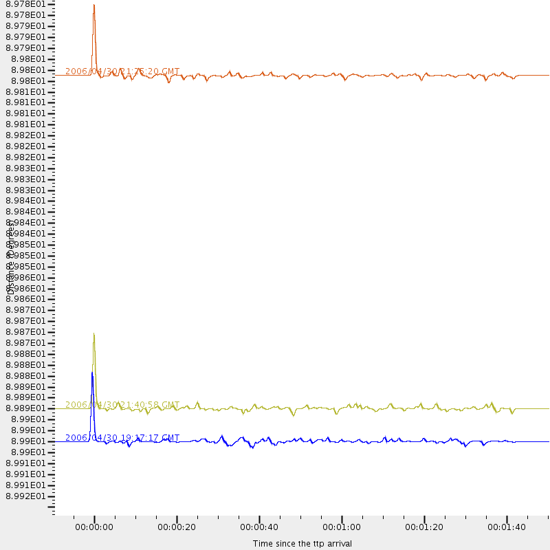
Events Used in the Stack
(3 events)| Radial Match | Distance | Baz | FERegion | Time | Lat/Lon | Depth | Magnitude |
| 95.4971 | 89.8 deg | 118.656 deg | Near Coast Of Northern Chile | 2006/04/30 21:25:20 GMT | (-27.1, -71.1) | 34 km | 5.8 MW |
| 93.85967 | 89.9 deg | 118.543 deg | Near Coast Of Northern Chile | 2006/04/30 19:17:17 GMT | (-27.0, -71.0) | 27 km | 6.0 MB, 6.4 MS, 6.7 MW, 6.6 MW |
| 93.26985 | 89.9 deg | 118.758 deg | Near Coast Of Northern Chile | 2006/04/30 21:40:58 GMT | (-27.2, -71.1) | 12 km | 5.9 MB, 6.7 MS, 6.5 MW, 6.3 ML |
Losers
(10 events)| Radial Match | Distance | Baz | FERegion | Time | Lat/Lon | Depth | Magnitude | Reason |
| 89.954994 | 53.4 deg | 101.684 deg | West Of Galapagos Islands | 2006/05/01 20:13:28 GMT | (2.2, -99.0) | 10 km | 5.7 MW, 5.0 MB, 5.7 MW | |
| 74.12785 | 57.3 deg | 208.775 deg | Kermadec Islands Region | 2006/05/16 10:39:23 GMT | (-31.8, -179.3) | 152 km | 6.8 MB, 7.4 MW, 7.4 MW | |
| 73.95615 | 40.6 deg | 214.014 deg | Tonga Islands | 2006/04/30 19:33:18 GMT | (-15.5, -173.1) | 10 km | 5.8 MB, 5.9 MS, 5.9 MW | |
| 66.61228 | 53.2 deg | 208.862 deg | Kermadec Islands Region | 2006/05/01 02:25:41 GMT | (-28.3, -176.9) | 35 km | 5.7 MW | |
| 64.37949 | 53.4 deg | 208.684 deg | Kermadec Islands Region | 2006/05/01 02:24:41 GMT | (-28.5, -176.9) | 37 km | 5.7 MS, 5.3 MB, 5.7 MW | |
| 46.493565 | 62.1 deg | 252.624 deg | New Britain Region, P.N.G. | 2006/05/28 03:12:08 GMT | (-5.7, 151.1) | 34 km | 5.9 MB, 6.6 MS, 6.5 MW, 6.4 MW | |
| 42.651306 | 49.5 deg | 327.105 deg | Off East Coast Of Kamchatka | 2006/05/18 23:04:44 GMT | (54.6, 163.9) | 30 km | 5.7 MB, 5.3 MS, 5.7 MW, 5.7 MW | |
| 41.088432 | 71.5 deg | 259.252 deg | Irian Jaya, Indonesia | 2006/05/30 03:28:52 GMT | (-3.8, 140.1) | 30 km | 5.5 MB, 5.7 MS, 5.9 MW, 5.9 MW | |
| 38.808296 | 59.1 deg | 140.329 deg | Easter Island Region | 2006/05/24 00:32:32 GMT | (-27.6, -112.8) | 10 km | 5.6 MW, 5.2 MB, 5.5 MW | |
| 18.176022 | 55.5 deg | 227.224 deg | Loyalty Islands | 2006/05/24 09:45:34 GMT | (-20.4, 168.9) | 40 km | 5.5 MW |
