
Station YU CLE - CLE
Network: YU06 - DELTA LEVY Northern California
Nearby stations (2 deg radius)
| Station | Name | (Lat, Lon) | Start / End | Elevation |
| CLE | CLE | (38.19, -121.09) | 2012-06-01 / 2013-06-14 | 41 m |
| Crust2 Type: | L3,continental arc, Southern Andes, 0.2 km seds. |
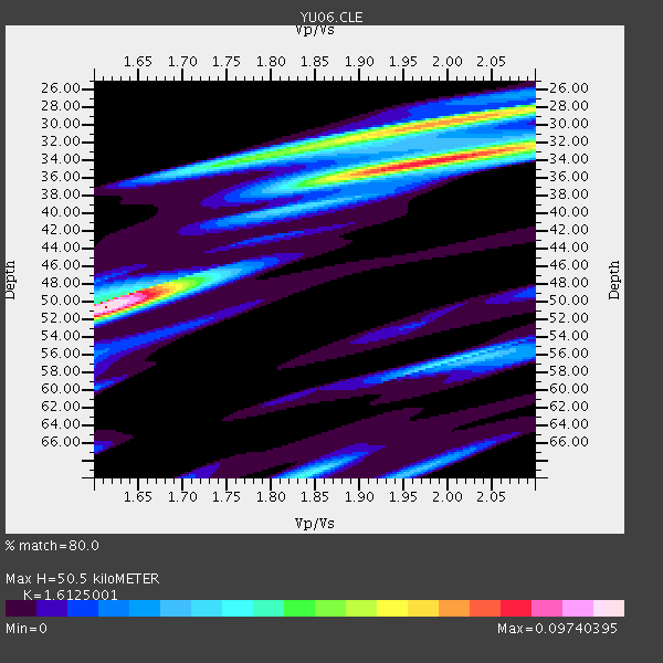
| Thickness Estimate: | 50 km |
| Thickness StdDev: | 0.9 km |
| Vp/Vs Estimate: | 1.61 |
| Vp/Vs StdDev: | 0.02 |
| Vs Estimate: | 4.091 km/s |
| Poisson's Ratio: | 0.19 |
| Peak Value: | 0.10 |
| Assumed Vp: | 6.597 km/s |
| Ps Weight: | 0.33333334 |
| PpPs Weight: | 0.33333334 |
| PsPs Weight: | 0.33333328 |
| Residual Complexity: | 0.830 |
| Nearby stations H: | +- |
| (2.0 deg) Vp/Vs: | +- |
1 with match > 90% ( 3.8461537 %) and 2 with match > 80% ( 7.6923075 %) out of 26.
Download stack as xyz text file.
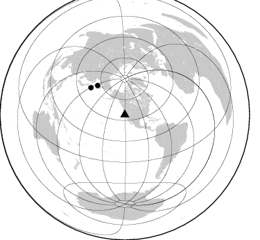
Azimuth Distribution of Events:
Prior Results for this Station
| Study | Thickness | Vp/Vs | Vp | Vs | Poissons Ratio | Extra |
| EARS | 50 km | 1.61 | 6.597 km/s | 4.091 km/s | 0.19 | |
| Crust2.0 | 40 km | 1.77 | 6.597 km/s | 3.723 km/s | 0.27 | L3,continental arc, Southern Andes, 0.2 km seds. |
| Global Maxima | 50 km | 1.61 | 6.597 km/s | 4.091 km/s | 0.19 | amp=0.09740395 |
| Local Maxima 1 | 34 km | 1.99 | 6.597 km/s | 3.324 km/s | 0.33 | amp=0.08059094 |
| Local Maxima 2 | 30 km | 1.96 | 6.597 km/s | 3.375 km/s | 0.32 | amp=0.06526993 |
| Local Maxima 3 | 34 km | 1.76 | 6.597 km/s | 3.743 km/s | 0.26 | amp=0.040258013 |
| Local Maxima 4 | 48 km | 1.66 | 6.597 km/s | 3.98 km/s | 0.21 | amp=0.03997356 |
| Predicted Arrivals for vertical incidence (zero ray parameter) | |
| Ps | 4.69 SECOND |
| PpPs | 20.00 SECOND |
| PsPs/PpSs | 24.69 SECOND |
Events Processed for this Station
Download zip of receiver functions as SAC
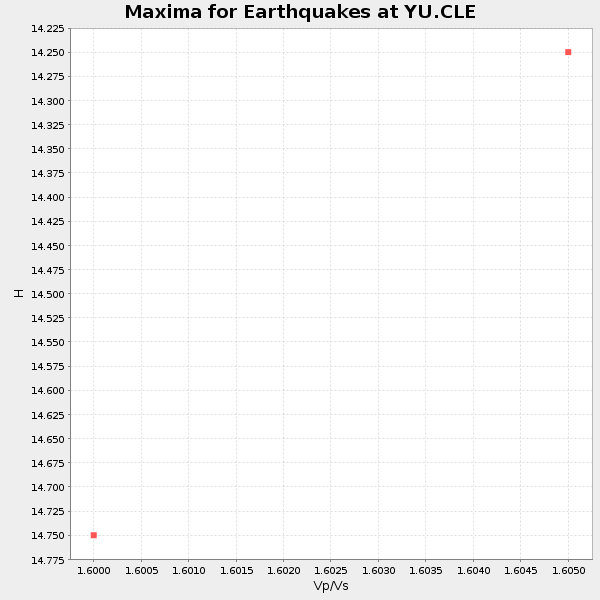
Plot maxima for each earthquake.
Events Used in the Stack
(2 events)| Radial Match | Distance | Baz | FERegion | Time | Lat/Lon | Depth | Magnitude |
| 91.62718 | 62.5 deg | 308.557 deg | Kuril Islands | 2013/04/19 03:05:52 GMT | (46.2, 150.8) | 110 km | 7.2 MW, 7.1 MB, 7.2 MW |
| 88.926994 | 57.5 deg | 316.939 deg | Sea Of Okhotsk | 2013/05/24 05:44:48 GMT | (54.9, 153.2) | 598 km | 8.4 MW, 7.5 MB, 8.3 MW |
Losers
(24 events)| Radial Match | Distance | Baz | FERegion | Time | Lat/Lon | Depth | Magnitude | Reason |
| 85.848114 | 81.4 deg | 286.956 deg | Mariana Islands | 2013/05/14 00:32:25 GMT | (18.7, 145.3) | 602 km | 6.8 MW, 6.2 MB, 6.8 MW | |
| 78.60532 | 56.8 deg | 310.295 deg | East Of Kuril Islands | 2013/04/19 19:58:40 GMT | (50.0, 157.7) | 15 km | 6.1 MW, 5.9 MB, 6.0 MW, 6.1 MS | |
| 73.105194 | 85.0 deg | 225.733 deg | Kermadec Islands Region | 2013/04/22 23:40:47 GMT | (-29.8, -176.2) | 13 km | 5.5 MB | |
| 72.384445 | 75.4 deg | 232.743 deg | Tonga Islands | 2013/05/11 20:46:57 GMT | (-18.0, -175.1) | 213 km | 5.8 MB, 6.4 MW, 6.4 MW | |
| 66.01795 | 83.4 deg | 232.805 deg | South Of Fiji Islands | 2013/06/07 12:54:09 GMT | (-23.9, 179.1) | 546 km | 5.9 MW, 5.5 MB, 5.9 MW | |
| 65.46114 | 85.7 deg | 228.231 deg | Kermadec Islands Region | 2013/04/26 06:53:28 GMT | (-28.7, -178.9) | 351 km | 6.1 MW, 5.8 MB, 6.2 MW | |
| 64.637886 | 37.7 deg | 309.142 deg | Fox Islands, Aleutian Islands | 2013/05/12 20:06:41 GMT | (52.5, -172.0) | 8.0 km | 5.7 MB, 5.1 MS, 5.4 MW, 5.3 MW | |
| 59.93783 | 37.4 deg | 117.743 deg | Honduras | 2013/04/10 19:14:01 GMT | (15.5, -87.2) | 3.5 km | 5.5 MW | |
| 58.902695 | 76.3 deg | 313.806 deg | E. Russia-N.E. China Border Reg. | 2013/04/06 00:29:55 GMT | (42.7, 131.0) | 563 km | 5.8 MW, 5.5 MB, 5.9 MW | |
| 57.090786 | 86.5 deg | 242.438 deg | Vanuatu Islands | 2013/04/13 22:49:50 GMT | (-19.1, 169.5) | 280 km | 6.0 MW, 5.9 MB, 6.0 MW | |
| 56.109314 | 57.1 deg | 310.586 deg | Kuril Islands | 2013/04/20 13:12:50 GMT | (50.1, 157.1) | 18 km | 6.1 MW, 5.8 MB, 5.9 MS, 6.0 MW | |
| 55.4733 | 76.4 deg | 302.627 deg | Near S. Coast Of Honshu, Japan | 2013/04/17 08:57:19 GMT | (34.1, 139.4) | 11 km | 5.8 MW | |
| 55.02975 | 54.6 deg | 312.381 deg | Off East Coast Of Kamchatka | 2013/05/21 04:59:35 GMT | (52.3, 160.1) | 18 km | 5.7 MW, 5.6 MS, 5.7 MW | |
| 54.80189 | 62.9 deg | 307.669 deg | Kuril Islands | 2013/06/04 11:00:09 GMT | (45.4, 150.9) | 24 km | 5.6 MW, 5.5 MW | |
| 54.481968 | 93.7 deg | 181.801 deg | Southern East Pacific Rise | 2013/04/05 22:31:45 GMT | (-55.8, -124.3) | 24 km | 5.5 MW | |
| 54.16797 | 89.7 deg | 264.029 deg | New Britain Region, P.N.G. | 2013/05/15 03:36:01 GMT | (-4.6, 152.8) | 59 km | 5.7 MW, 5.7 MB, 5.7 MW | |
| 50.35493 | 44.8 deg | 119.544 deg | Panama-Costa Rica Border Region | 2013/05/27 09:41:14 GMT | (9.4, -82.6) | 9.2 km | 5.7 MW, 5.6 MB, 5.7 MW | |
| 48.02213 | 54.5 deg | 312.225 deg | Off East Coast Of Kamchatka | 2013/05/20 00:13:17 GMT | (52.3, 160.3) | 35 km | 5.5 MW, 5.5 MB | |
| 47.116096 | 80.6 deg | 290.42 deg | Mariana Islands Region | 2013/05/12 23:05:27 GMT | (21.9, 143.7) | 167 km | 5.5 MW, 5.1 MB, 5.6 MW | |
| 46.796463 | 93.5 deg | 181.205 deg | Southern East Pacific Rise | 2013/04/06 10:29:20 GMT | (-55.6, -123.2) | 9.9 km | 5.5 MW | |
| 46.118076 | 69.0 deg | 128.441 deg | Central Peru | 2013/05/21 23:02:45 GMT | (-13.8, -72.3) | 92 km | 5.8 MW, 5.7 MB, 5.8 MW | |
| 45.727806 | 77.8 deg | 231.46 deg | Tonga Islands | 2013/05/23 21:07:46 GMT | (-20.6, -175.8) | 150 km | 6.3 MW, 5.7 MB, 6.3 MW | |
| 42.151627 | 90.5 deg | 40.341 deg | Northern Algeria | 2013/05/19 09:07:26 GMT | (36.7, 5.3) | 6.7 km | 5.5 ML | |
| 37.203136 | 88.2 deg | 302.635 deg | Ryukyu Islands, Japan | 2013/06/13 13:24:45 GMT | (26.5, 128.9) | 20 km | 5.6 MW, 5.6 MW, 5.9 MB |
