
Station YV HJO - Hjonadal
Network: YV00 - North East Atlantic Tomography (NEAT)
Nearby stations (2 deg radius)
| Station | Name | (Lat, Lon) | Start / End | Elevation |
| HJO | Hjonadal | (70.35, -28.16) | 2001-08-16 / 2002-08-13 | 40 m |
| Crust2 Type: | GE,Archean, no seds. |
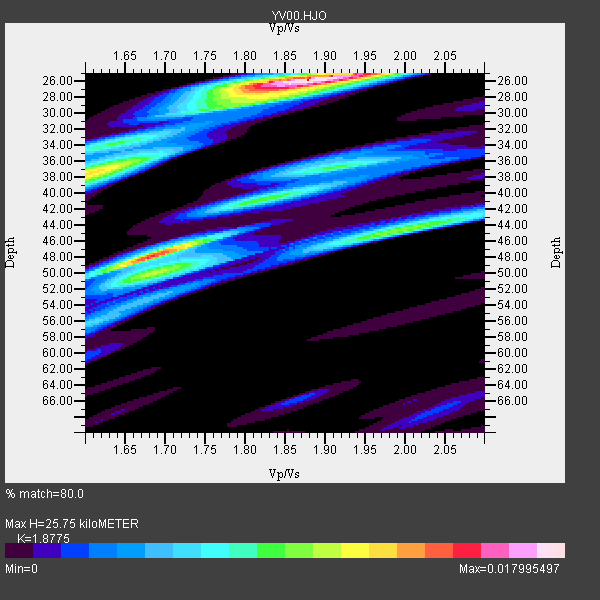
| Thickness Estimate: | 26 km |
| Thickness StdDev: | 8.2 km |
| Vp/Vs Estimate: | 1.88 |
| Vp/Vs StdDev: | 0.12 |
| Vs Estimate: | 3.438 km/s |
| Poisson's Ratio: | 0.30 |
| Peak Value: | 0.02 |
| Assumed Vp: | 6.455 km/s |
| Ps Weight: | 0.33333334 |
| PpPs Weight: | 0.33333334 |
| PsPs Weight: | 0.33333328 |
| Residual Complexity: | 0.739 |
| Nearby stations H: | +- |
| (2.0 deg) Vp/Vs: | +- |
1 with match > 90% ( 7.142857 %) and 7 with match > 80% ( 50.0 %) out of 14.
Download stack as xyz text file.
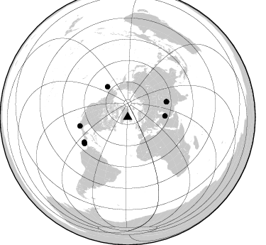
Azimuth Distribution of Events:
Prior Results for this Station
| Study | Thickness | Vp/Vs | Vp | Vs | Poissons Ratio | Extra |
| EARS | 26 km | 1.88 | 6.455 km/s | 3.438 km/s | 0.30 | |
| Crust2.0 | 42 km | 1.76 | 6.455 km/s | 3.663 km/s | 0.26 | GE,Archean, no seds. |
| Global Maxima | 26 km | 1.88 | 6.455 km/s | 3.438 km/s | 0.30 | amp=0.017995497 |
| Local Maxima 1 | 48 km | 1.69 | 6.455 km/s | 3.831 km/s | 0.23 | amp=0.014528802 |
| Local Maxima 2 | 38 km | 1.60 | 6.455 km/s | 4.028 km/s | 0.18 | amp=0.012019389 |
| Local Maxima 3 | 44 km | 1.99 | 6.455 km/s | 3.24 km/s | 0.33 | amp=0.009562107 |
| Local Maxima 4 | 37 km | 1.90 | 6.455 km/s | 3.393 km/s | 0.31 | amp=0.007935863 |
| Predicted Arrivals for vertical incidence (zero ray parameter) | |
| Ps | 3.50 SECOND |
| PpPs | 11.48 SECOND |
| PsPs/PpSs | 14.98 SECOND |
Events Processed for this Station
Download zip of receiver functions as SAC
Plot maxima for each earthquake.
Events Used in the Stack
(7 events)| Radial Match | Distance | Baz | FERegion | Time | Lat/Lon | Depth | Magnitude |
| 90.66964 | 51.6 deg | 326.374 deg | South Of Alaska | 2002/05/25 05:36:31 GMT | (53.8, -161.1) | 33 km | 5.5 MB, 6.1 MS, 6.5 MW, 6.4 MW |
| 89.35096 | 70.7 deg | 240.053 deg | Costa Rica | 2002/06/16 02:46:14 GMT | (8.8, -84.0) | 35 km | 5.4 MB, 6.2 MS, 6.4 MW, 6.4 MW |
| 88.57966 | 59.0 deg | 68.538 deg | Hindu Kush Region, Afghanistan | 2002/03/03 12:08:07 GMT | (36.4, 70.4) | 209 km | 6.3 MB |
| 88.51788 | 58.9 deg | 68.467 deg | Hindu Kush Region, Afghanistan | 2002/03/03 12:08:19 GMT | (36.5, 70.5) | 226 km | 6.6 MB, 7.4 MW, 7.3 MW |
| 86.847046 | 68.3 deg | 259.485 deg | Near Coast Of Guerrero, Mexico | 2002/04/18 05:02:46 GMT | (17.0, -100.9) | 25 km | 5.4 MB, 6.0 MS, 6.3 MW, 6.1 MW |
| 84.67236 | 71.2 deg | 238.589 deg | South Of Panama | 2002/07/31 00:16:44 GMT | (7.9, -82.8) | 10 km | 6.0 MB, 6.4 MS, 6.5 MW, 6.4 MW |
| 81.91447 | 52.6 deg | 88.094 deg | Western Iran | 2002/06/22 02:58:21 GMT | (35.6, 49.0) | 10 km | 6.2 MB, 6.4 MS, 6.5 MW, 6.5 MW |
Losers
(7 events)| Radial Match | Distance | Baz | FERegion | Time | Lat/Lon | Depth | Magnitude | Reason |
| 70.530785 | 56.0 deg | 353.617 deg | Near East Coast Of Kamchatka | 2002/05/08 19:45:18 GMT | (53.8, 160.8) | 39 km | 5.8 MB, 5.4 MS, 5.9 MW, 5.8 MW | |
| 67.75467 | 65.2 deg | 16.76 deg | E. Russia-N.E. China Border Reg. | 2002/06/28 17:19:30 GMT | (43.8, 130.7) | 566 km | 6.7 MB, 7.3 MW, 7.3 MW | |
| 58.43847 | 72.6 deg | 232.731 deg | Near West Coast Of Colombia | 2002/08/08 13:39:58 GMT | (5.0, -77.8) | 43 km | 5.4 MB, 5.0 MS, 5.9 MW, 5.7 MW | |
| 56.98431 | 83.5 deg | 27.001 deg | Taiwan Region | 2002/05/28 16:45:17 GMT | (24.1, 122.3) | 33 km | 5.8 MB, 5.9 MS, 6.0 MW, 6.0 MW | |
| 53.611042 | 64.0 deg | 71.379 deg | Pakistan | 2002/07/13 20:06:27 GMT | (30.8, 70.0) | 33 km | 5.4 MB, 5.7 MS, 5.8 MW, 5.6 MW | |
| 45.15122 | 80.2 deg | 11.385 deg | Southeast Of Honshu, Japan | 2002/08/02 23:11:39 GMT | (29.3, 139.0) | 426 km | 5.5 MB, 6.3 MW, 6.3 MW | |
| 30.540407 | 82.9 deg | 27.214 deg | Taiwan | 2002/05/15 03:46:05 GMT | (24.6, 121.9) | 10 km | 5.5 MB, 6.2 MS, 6.2 MW, 6.2 MW |
