
Station YV KAG - Kagssortoq
Network: YV00 - North East Atlantic Tomography (NEAT)
Nearby stations (2 deg radius)
| Station | Name | (Lat, Lon) | Start / End | Elevation |
| KAG | Kagssortoq | (63.25, -42.03) | 2001-08-14 / 2002-08-14 | 28 m |
| Crust2 Type: | F2,Archean 0.5 km ice, no seds. |
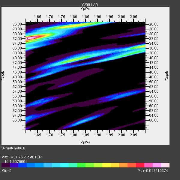
| Thickness Estimate: | 32 km |
| Thickness StdDev: | 6.3 km |
| Vp/Vs Estimate: | 1.61 |
| Vp/Vs StdDev: | 0.19 |
| Vs Estimate: | 3.996 km/s |
| Poisson's Ratio: | 0.18 |
| Peak Value: | 0.01 |
| Assumed Vp: | 6.424 km/s |
| Ps Weight: | 0.33333334 |
| PpPs Weight: | 0.33333334 |
| PsPs Weight: | 0.33333328 |
| Residual Complexity: | 0.778 |
| Nearby stations H: | +- |
| (2.0 deg) Vp/Vs: | +- |
0 with match > 90% ( 0.0 %) and 5 with match > 80% ( 50.0 %) out of 10.
Download stack as xyz text file.
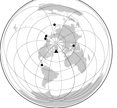
Azimuth Distribution of Events:
Prior Results for this Station
| Study | Thickness | Vp/Vs | Vp | Vs | Poissons Ratio | Extra |
| EARS | 32 km | 1.61 | 6.424 km/s | 3.996 km/s | 0.18 | |
| Crust2.0 | 38 km | 1.76 | 6.424 km/s | 3.642 km/s | 0.26 | F2,Archean 0.5 km ice, no seds. |
| Global Maxima | 32 km | 1.61 | 6.424 km/s | 3.996 km/s | 0.18 | amp=0.012619374 |
| Local Maxima 1 | 35 km | 2.10 | 6.424 km/s | 3.066 km/s | 0.35 | amp=0.008191968 |
| Local Maxima 2 | 26 km | 1.80 | 6.424 km/s | 3.569 km/s | 0.28 | amp=0.0078319125 |
| Local Maxima 3 | 41 km | 1.80 | 6.424 km/s | 3.569 km/s | 0.28 | amp=0.007235609 |
| Local Maxima 4 | 36 km | 1.60 | 6.424 km/s | 4.015 km/s | 0.18 | amp=0.0056165583 |
| Predicted Arrivals for vertical incidence (zero ray parameter) | |
| Ps | 3.00 SECOND |
| PpPs | 12.89 SECOND |
| PsPs/PpSs | 15.89 SECOND |
Events Processed for this Station
Download zip of receiver functions as SAC
Plot maxima for each earthquake.
Events Used in the Stack
(5 events)| Radial Match | Distance | Baz | FERegion | Time | Lat/Lon | Depth | Magnitude |
| 88.344795 | 59.4 deg | 326.871 deg | Andreanof Islands, Aleutian Is. | 2002/03/17 03:57:47 GMT | (51.5, -173.3) | 33 km | 5.5 MB, 5.3 MS, 5.5 ML |
| 86.15587 | 86.5 deg | 356.545 deg | Southeast Of Honshu, Japan | 2002/03/20 04:00:18 GMT | (30.5, 142.0) | 10 km | 5.5 MB, 5.7 MS, 5.9 MW, 5.8 MW |
| 85.39819 | 54.0 deg | 320.174 deg | South Of Alaska | 2002/05/25 05:36:31 GMT | (53.8, -161.1) | 33 km | 5.5 MB, 6.1 MS, 6.5 MW, 6.4 MW |
| 85.38844 | 62.5 deg | 226.81 deg | South Of Panama | 2002/07/31 00:16:44 GMT | (7.9, -82.8) | 10 km | 6.0 MB, 6.4 MS, 6.5 MW, 6.4 MW |
| 80.09744 | 59.3 deg | 71.272 deg | Western Iran | 2002/06/22 02:58:21 GMT | (35.6, 49.0) | 10 km | 6.2 MB, 6.4 MS, 6.5 MW, 6.5 MW |
Losers
(5 events)| Radial Match | Distance | Baz | FERegion | Time | Lat/Lon | Depth | Magnitude | Reason |
| 74.020905 | 73.2 deg | 5.519 deg | E. Russia-N.E. China Border Reg. | 2002/06/28 17:19:30 GMT | (43.8, 130.7) | 566 km | 6.7 MB, 7.3 MW, 7.3 MW | |
| 70.44718 | 61.9 deg | 344.898 deg | Near East Coast Of Kamchatka | 2002/05/08 19:45:18 GMT | (53.8, 160.8) | 39 km | 5.8 MB, 5.4 MS, 5.9 MW, 5.8 MW | |
| 63.708195 | 50.2 deg | 289.417 deg | Off Coast Of Oregon | 2002/07/09 18:40:35 GMT | (43.5, -127.2) | 10 km | 5.5 MB, 5.5 MS, 6.0 MW, 5.8 MW | |
| 58.471024 | 80.5 deg | 76.344 deg | Arabian Sea | 2002/08/13 08:37:22 GMT | (14.7, 55.8) | 10 km | 5.8 MB, 5.5 MS, 5.8 MW, 5.6 MW | |
| 49.723198 | 92.1 deg | 14.309 deg | Taiwan Region | 2002/07/11 07:36:26 GMT | (24.1, 122.3) | 44 km | 5.6 MB, 5.6 MS, 5.8 MW, 5.8 MW |
