
Station YW 505 - Broadband at Wavefields Community Experiment, OK,
Network: YW16 - IRIS Community Wavefield Experiment in Oklahoma
Nearby stations (2 deg radius)
| Station | Name | (Lat, Lon) | Start / End | Elevation |
| 505 | Broadband at Wavefields Community Experiment, OK, | (36.60, -97.68) | 2016-06-22 / 2016-12-30 | 332 m |
| Crust2 Type: | D5,thick Platform 2 km seds. |
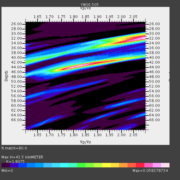
| Thickness Estimate: | 44 km |
| Thickness StdDev: | 5.5 km |
| Vp/Vs Estimate: | 1.81 |
| Vp/Vs StdDev: | 0.14 |
| Vs Estimate: | 3.587 km/s |
| Poisson's Ratio: | 0.28 |
| Peak Value: | 0.06 |
| Assumed Vp: | 6.483 km/s |
| Ps Weight: | 0.33333334 |
| PpPs Weight: | 0.33333334 |
| PsPs Weight: | 0.33333328 |
| Residual Complexity: | 0.773 |
| Nearby stations H: | +- |
| (2.0 deg) Vp/Vs: | +- |
0 with match > 90% ( 0.0 %) and 2 with match > 80% ( 50.0 %) out of 4.
Download stack as xyz text file.
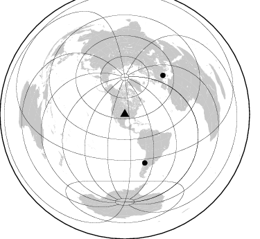
Azimuth Distribution of Events:
Prior Results for this Station
| Study | Thickness | Vp/Vs | Vp | Vs | Poissons Ratio | Extra |
| EARS | 44 km | 1.81 | 6.483 km/s | 3.587 km/s | 0.28 | |
| Crust2.0 | 46 km | 1.78 | 6.483 km/s | 3.648 km/s | 0.27 | D5,thick Platform 2 km seds. |
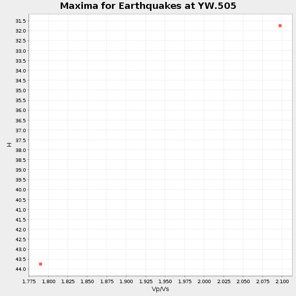
| Global Maxima | 44 km | 1.81 | 6.483 km/s | 3.587 km/s | 0.28 | amp=0.058378734 |
| Local Maxima 1 | 32 km | 2.10 | 6.483 km/s | 3.091 km/s | 0.35 | amp=0.054417145 |
| Local Maxima 2 | 41 km | 1.64 | 6.483 km/s | 3.947 km/s | 0.21 | amp=0.03082284 |
| Local Maxima 3 | 41 km | 1.98 | 6.483 km/s | 3.282 km/s | 0.33 | amp=0.029088192 |
| Local Maxima 4 | 31 km | 2.02 | 6.483 km/s | 3.205 km/s | 0.34 | amp=0.02811544 |
| Predicted Arrivals for vertical incidence (zero ray parameter) | |
| Ps | 5.42 SECOND |
| PpPs | 18.84 SECOND |
| PsPs/PpSs | 24.26 SECOND |
Events Processed for this Station
Download zip of receiver functions as SAC
Plot maxima for each earthquake.
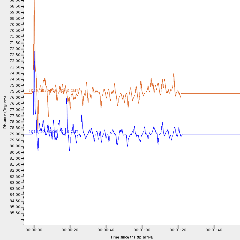
Events Used in the Stack
(2 events)| Radial Match | Distance | Baz | FERegion | Time | Lat/Lon | Depth | Magnitude |
| 89.42632 | 75.5 deg | 157.648 deg | Chile-Argentina Border Region | 2016/11/04 16:20:43 GMT | (-35.1, -71.0) | 91 km | 6.4 MWP, 6.4 MWW |
| 87.55881 | 78.9 deg | 44.479 deg | Central Italy | 2016/10/30 06:40:19 GMT | (42.9, 13.1) | 10 km | 6.6 MWW, 6.6 MWR |
Losers
(2 events)| Radial Match | Distance | Baz | FERegion | Time | Lat/Lon | Depth | Magnitude | Reason |
| 63.92698 | 78.8 deg | 44.438 deg | Central Italy | 2016/10/26 19:18:08 GMT | (42.9, 13.0) | 10 km | 6.1 MWW, 6.0 MWB, 6.1 MWR | |
| 42.053585 | 81.5 deg | 46.995 deg | Tyrrhenian Sea | 2016/10/28 20:02:48 GMT | (39.3, 13.5) | 448 km | 5.8 MWW, 5.8 MWB |

