
Station YW 508 - Broadband at Wavefields Community Experiment, OK,
Network: YW16 - IRIS Community Wavefield Experiment in Oklahoma
Nearby stations (2 deg radius)
| Station | Name | (Lat, Lon) | Start / End | Elevation |
| 508 | Broadband at Wavefields Community Experiment, OK, | (36.62, -97.71) | 2016-06-23 / 2016-12-30 | 323 m |
| Crust2 Type: | D5,thick Platform 2 km seds. |
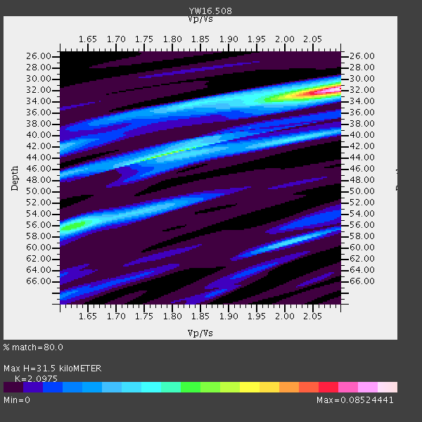
| Thickness Estimate: | 32 km |
| Thickness StdDev: | 9.6 km |
| Vp/Vs Estimate: | 2.10 |
| Vp/Vs StdDev: | 0.20 |
| Vs Estimate: | 3.091 km/s |
| Poisson's Ratio: | 0.35 |
| Peak Value: | 0.09 |
| Assumed Vp: | 6.483 km/s |
| Ps Weight: | 0.33333334 |
| PpPs Weight: | 0.33333334 |
| PsPs Weight: | 0.33333328 |
| Residual Complexity: | 0.640 |
| Nearby stations H: | +- |
| (2.0 deg) Vp/Vs: | +- |
0 with match > 90% ( 0.0 %) and 2 with match > 80% ( 22.222221 %) out of 9.
Download stack as xyz text file.
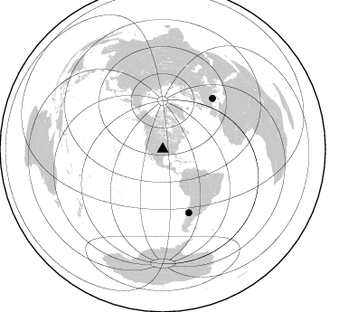
Azimuth Distribution of Events:
Prior Results for this Station
| Study | Thickness | Vp/Vs | Vp | Vs | Poissons Ratio | Extra |
| EARS | 32 km | 2.10 | 6.483 km/s | 3.091 km/s | 0.35 | |
| Crust2.0 | 46 km | 1.78 | 6.483 km/s | 3.648 km/s | 0.27 | D5,thick Platform 2 km seds. |
| Global Maxima | 32 km | 2.10 | 6.483 km/s | 3.091 km/s | 0.35 | amp=0.08524441 |
| Local Maxima 1 | 43 km | 1.79 | 6.483 km/s | 3.627 km/s | 0.27 | amp=0.04636533 |
| Local Maxima 2 | 56 km | 1.63 | 6.483 km/s | 3.965 km/s | 0.20 | amp=0.032575373 |
| Local Maxima 3 | 58 km | 2.02 | 6.483 km/s | 3.209 km/s | 0.34 | amp=0.028571274 |
| Local Maxima 4 | 42 km | 1.60 | 6.483 km/s | 4.052 km/s | 0.18 | amp=0.023171594 |
| Predicted Arrivals for vertical incidence (zero ray parameter) | |
| Ps | 5.33 SECOND |
| PpPs | 15.05 SECOND |
| PsPs/PpSs | 20.38 SECOND |
Events Processed for this Station
Download zip of receiver functions as SAC
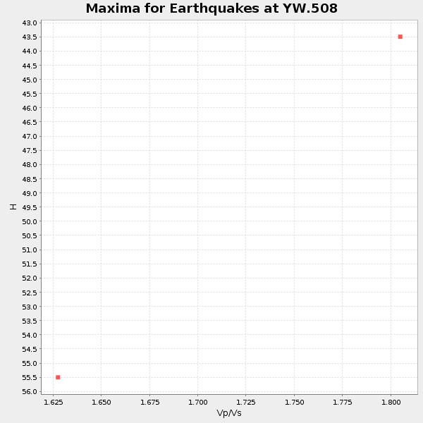
Plot maxima for each earthquake.
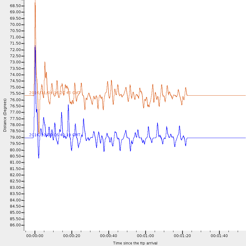
Events Used in the Stack
(2 events)| Radial Match | Distance | Baz | FERegion | Time | Lat/Lon | Depth | Magnitude |
| 87.44743 | 78.9 deg | 44.469 deg | Central Italy | 2016/10/30 06:40:19 GMT | (42.9, 13.1) | 10 km | 6.6 MWW, 6.6 MWR |
| 85.99881 | 75.6 deg | 157.63 deg | Chile-Argentina Border Region | 2016/11/04 16:20:43 GMT | (-35.1, -71.0) | 91 km | 6.4 MWP, 6.4 MWW |
Losers
(7 events)| Radial Match | Distance | Baz | FERegion | Time | Lat/Lon | Depth | Magnitude | Reason |
| 65.54824 | 78.9 deg | 44.499 deg | Central Italy | 2016/10/26 17:10:37 GMT | (42.9, 13.0) | 10 km | 5.5 MWW | |
| 63.265015 | 38.6 deg | 113.905 deg | Leeward Islands | 2016/10/18 22:08:14 GMT | (15.2, -61.5) | 143 km | 5.6 MWW, 5.6 MWB | |
| 59.5562 | 78.8 deg | 44.429 deg | Central Italy | 2016/10/26 19:18:08 GMT | (42.9, 13.0) | 10 km | 6.1 MWW, 6.0 MWB, 6.1 MWR | |
| 51.799812 | 72.3 deg | 182.807 deg | Southeast Of Easter Island | 2016/10/08 04:37:41 GMT | (-36.0, -101.0) | 10 km | 5.6 MWC, 5.6 MWC | |
| 45.396675 | 73.9 deg | 158.351 deg | Off Coast Of Central Chile | 2016/10/27 20:32:55 GMT | (-33.8, -72.5) | 15 km | 5.9 MWB | |
| 35.109875 | 80.0 deg | 318.013 deg | East Of Kuril Islands | 2016/10/23 20:25:26 GMT | (44.0, 148.2) | 30 km | 5.8 MB | |
| 34.649643 | 81.5 deg | 46.984 deg | Tyrrhenian Sea | 2016/10/28 20:02:48 GMT | (39.3, 13.5) | 448 km | 5.8 MWW, 5.8 MWB |

