
Station YW 512 - Broadband at Wavefields Community Experiment, OK,
Network: YW16 - IRIS Community Wavefield Experiment in Oklahoma
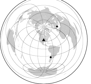
Nearby stations (2 deg radius)
| Station | Name | (Lat, Lon) | Start / End | Elevation |
| 512 | Broadband at Wavefields Community Experiment, OK, | (36.63, -97.67) | 2016-06-23 / 2016-12-30 | 323 m |
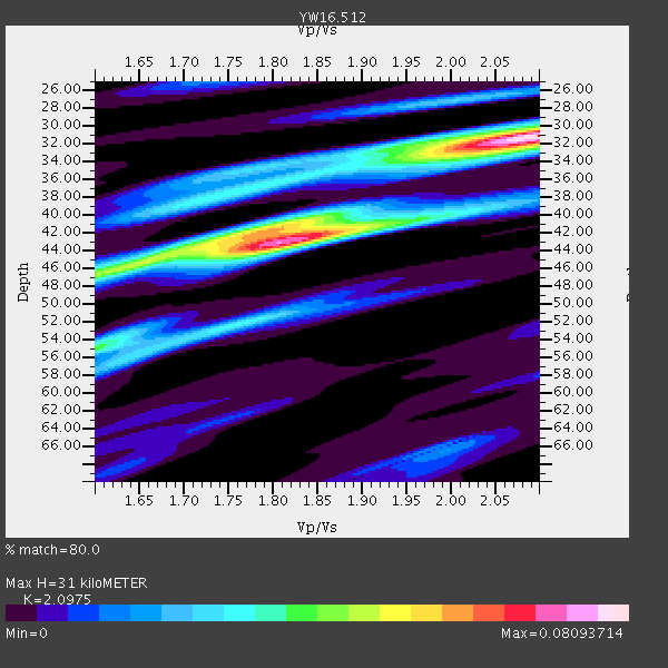
| Crust2 Type: | D5,thick Platform 2 km seds. |
| Thickness Estimate: | 31 km |
| Thickness StdDev: | 5.7 km |
| Vp/Vs Estimate: | 2.10 |
| Vp/Vs StdDev: | 0.15 |
| Vs Estimate: | 3.091 km/s |
| Poisson's Ratio: | 0.35 |
| Peak Value: | 0.08 |
| Assumed Vp: | 6.483 km/s |
| Ps Weight: | 0.33333334 |
| PpPs Weight: | 0.33333334 |
| PsPs Weight: | 0.33333328 |
| Residual Complexity: | 0.777 |
| Nearby stations H: | +- |
| (2.0 deg) Vp/Vs: | +- |
0 with match > 90% ( 0.0 %) and 2 with match > 80% ( 16.666666 %) out of 12.
Download stack as xyz text file.
Azimuth Distribution of Events:
Prior Results for this Station
| Study | Thickness | Vp/Vs | Vp | Vs | Poissons Ratio | Extra |
| EARS | 31 km | 2.10 | 6.483 km/s | 3.091 km/s | 0.35 | |
| Crust2.0 | 46 km | 1.78 | 6.483 km/s | 3.648 km/s | 0.27 | D5,thick Platform 2 km seds. |
| Global Maxima | 31 km | 2.10 | 6.483 km/s | 3.091 km/s | 0.35 | amp=0.08093714 |
| Local Maxima 1 | 43 km | 1.82 | 6.483 km/s | 3.567 km/s | 0.28 | amp=0.07022917 |
| Local Maxima 2 | 42 km | 1.76 | 6.483 km/s | 3.683 km/s | 0.26 | amp=0.041731086 |
| Local Maxima 3 | 52 km | 1.76 | 6.483 km/s | 3.673 km/s | 0.26 | amp=0.0307713 |
| Local Maxima 4 | 47 km | 1.60 | 6.483 km/s | 4.052 km/s | 0.18 | amp=0.029766198 |
| Predicted Arrivals for vertical incidence (zero ray parameter) | |
| Ps | 5.25 SECOND |
| PpPs | 14.81 SECOND |
| PsPs/PpSs | 20.06 SECOND |
Events Processed for this Station
Download zip of receiver functions as SAC
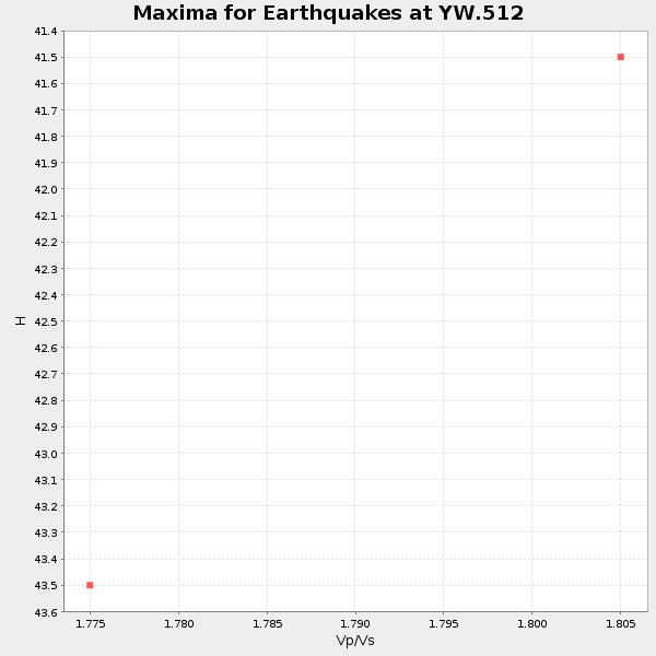
Plot maxima for each earthquake.
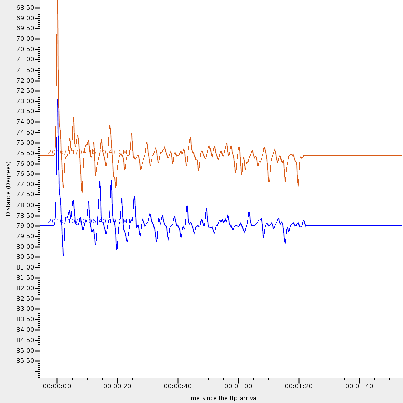
Events Used in the Stack
(2 events)| Radial Match | Distance | Baz | FERegion | Time | Lat/Lon | Depth | Magnitude |
| 87.55315 | 78.9 deg | 44.491 deg | Central Italy | 2016/10/30 06:40:19 GMT | (42.9, 13.1) | 10 km | 6.6 MWW, 6.6 MWR |
| 86.484695 | 75.6 deg | 157.663 deg | Chile-Argentina Border Region | 2016/11/04 16:20:43 GMT | (-35.1, -71.0) | 91 km | 6.4 MWP, 6.4 MWW |
Losers
(10 events)| Radial Match | Distance | Baz | FERegion | Time | Lat/Lon | Depth | Magnitude | Reason |
| 70.0603 | 38.6 deg | 113.967 deg | Leeward Islands | 2016/10/18 22:08:14 GMT | (15.2, -61.5) | 143 km | 5.6 MWW, 5.6 MWB | |
| 69.95577 | 78.8 deg | 44.45 deg | Central Italy | 2016/10/26 19:18:08 GMT | (42.9, 13.0) | 10 km | 6.1 MWW, 6.0 MWB, 6.1 MWR | |
| 60.898605 | 84.5 deg | 95.93 deg | North Of Ascension Island | 2016/10/27 01:03:12 GMT | (-1.5, -15.6) | 10 km | 5.6 MWW, 5.5 MWB | |
| 59.629932 | 80.0 deg | 318.031 deg | East Of Kuril Islands | 2016/10/23 20:25:26 GMT | (44.0, 148.2) | 30 km | 5.8 MB | |
| 46.172447 | 78.8 deg | 44.521 deg | Central Italy | 2016/10/26 17:10:37 GMT | (42.9, 13.0) | 10 km | 5.5 MWW | |
| 45.310738 | 33.4 deg | 151.943 deg | South Of Panama | 2016/11/12 20:08:46 GMT | (6.1, -82.6) | 10 km | 5.6 Mwb | |
| 43.906113 | 70.4 deg | 151.729 deg | La Rioja Province, Argentina | 2016/11/13 01:01:51 GMT | (-28.1, -67.3) | 121 km | 5.7 MB | |
| 42.03336 | 72.4 deg | 182.841 deg | Southeast Of Easter Island | 2016/10/08 04:37:41 GMT | (-36.0, -101.0) | 10 km | 5.6 MWC, 5.6 MWC | |
| 29.16254 | 81.4 deg | 47.007 deg | Tyrrhenian Sea | 2016/10/28 20:02:48 GMT | (39.3, 13.5) | 448 km | 5.8 MWW, 5.8 MWB | |
| 20.335741 | 76.2 deg | 160.27 deg | Near Coast Of Central Chile | 2016/11/08 04:55:44 GMT | (-36.6, -73.6) | 17 km | 5.9 MO |

