
Station YW 513 - Broadband at Wavefields Community Experiment, OK,
Network: YW16 - IRIS Community Wavefield Experiment in Oklahoma
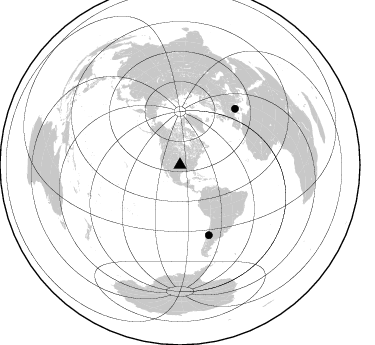
Nearby stations (2 deg radius)
| Station | Name | (Lat, Lon) | Start / End | Elevation |
| 513 | Broadband at Wavefields Community Experiment, OK, | (36.62, -97.64) | 2016-06-24 / 2016-12-30 | 324 m |
| Crust2 Type: | D5,thick Platform 2 km seds. |
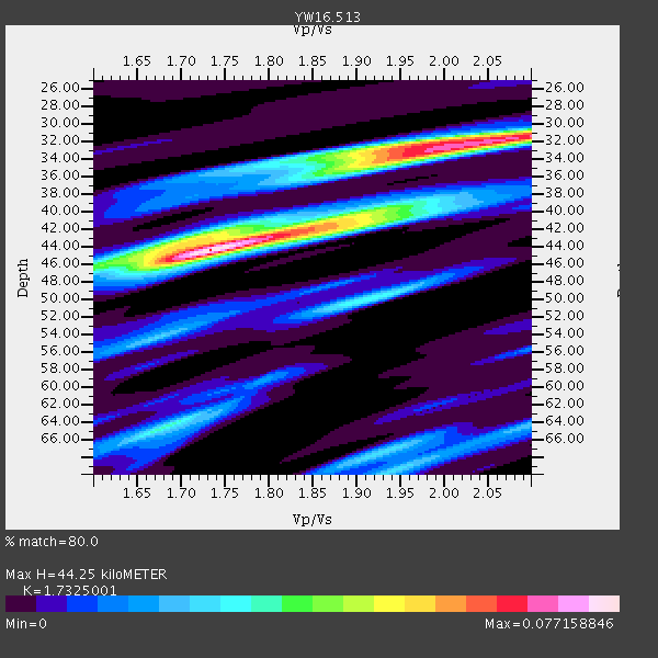
| Thickness Estimate: | 44 km |
| Thickness StdDev: | 7.1 km |
| Vp/Vs Estimate: | 1.73 |
| Vp/Vs StdDev: | 0.01 |
| Vs Estimate: | 3.742 km/s |
| Poisson's Ratio: | 0.25 |
| Peak Value: | 0.08 |
| Assumed Vp: | 6.483 km/s |
| Ps Weight: | 0.33333334 |
| PpPs Weight: | 0.33333334 |
| PsPs Weight: | 0.33333328 |
| Residual Complexity: | 0.765 |
| Nearby stations H: | +- |
| (2.0 deg) Vp/Vs: | +- |
0 with match > 90% ( 0.0 %) and 2 with match > 80% ( 28.571428 %) out of 7.
Download stack as xyz text file.
Azimuth Distribution of Events:
Prior Results for this Station
| Study | Thickness | Vp/Vs | Vp | Vs | Poissons Ratio | Extra |
| EARS | 44 km | 1.73 | 6.483 km/s | 3.742 km/s | 0.25 | |
| Crust2.0 | 46 km | 1.78 | 6.483 km/s | 3.648 km/s | 0.27 | D5,thick Platform 2 km seds. |
| Global Maxima | 44 km | 1.73 | 6.483 km/s | 3.742 km/s | 0.25 | amp=0.077158846 |
| Local Maxima 1 | 32 km | 2.03 | 6.483 km/s | 3.201 km/s | 0.34 | amp=0.06538057 |
| Local Maxima 2 | 40 km | 1.90 | 6.483 km/s | 3.412 km/s | 0.31 | amp=0.039602634 |
| Local Maxima 3 | 32 km | 1.94 | 6.483 km/s | 3.346 km/s | 0.32 | amp=0.034894165 |
| Local Maxima 4 | 64 km | 1.69 | 6.483 km/s | 3.847 km/s | 0.23 | amp=0.03340695 |
| Predicted Arrivals for vertical incidence (zero ray parameter) | |
| Ps | 5.00 SECOND |
| PpPs | 18.65 SECOND |
| PsPs/PpSs | 23.65 SECOND |
Events Processed for this Station
Download zip of receiver functions as SAC
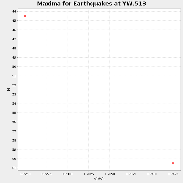
Plot maxima for each earthquake.
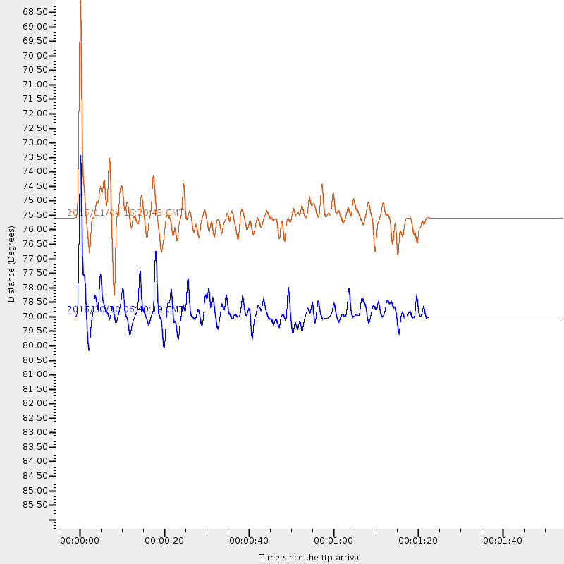
Events Used in the Stack
(2 events)| Radial Match | Distance | Baz | FERegion | Time | Lat/Lon | Depth | Magnitude |
| 89.18577 | 75.5 deg | 157.685 deg | Chile-Argentina Border Region | 2016/11/04 16:20:43 GMT | (-35.1, -71.0) | 91 km | 6.4 MWP, 6.4 MWW |
| 86.66366 | 78.9 deg | 44.503 deg | Central Italy | 2016/10/30 06:40:19 GMT | (42.9, 13.1) | 10 km | 6.6 MWW, 6.6 MWR |
Losers
(5 events)| Radial Match | Distance | Baz | FERegion | Time | Lat/Lon | Depth | Magnitude | Reason |
| 68.778 | 78.8 deg | 44.463 deg | Central Italy | 2016/10/26 19:18:08 GMT | (42.9, 13.0) | 10 km | 6.1 MWW, 6.0 MWB, 6.1 MWR | |
| 54.543594 | 38.5 deg | 113.983 deg | Leeward Islands | 2016/10/18 22:08:14 GMT | (15.2, -61.5) | 143 km | 5.6 MWW, 5.6 MWB | |
| 53.554604 | 80.0 deg | 318.046 deg | East Of Kuril Islands | 2016/10/23 20:25:26 GMT | (44.0, 148.2) | 30 km | 5.8 MB | |
| 45.20388 | 72.4 deg | 182.865 deg | Southeast Of Easter Island | 2016/10/08 04:37:41 GMT | (-36.0, -101.0) | 10 km | 5.6 MWC, 5.6 MWC | |
| 38.625908 | 93.9 deg | 320.161 deg | Western Honshu, Japan | 2016/10/21 05:07:23 GMT | (35.4, 133.8) | 10 km | 6.2 MWW, 6.6 MI |

