
Station YW 515 - Wavefields Community Experiment, OK, USA
Network: YW16 - IRIS Community Wavefield Experiment in Oklahoma
Nearby stations (2 deg radius)
| Station | Name | (Lat, Lon) | Start / End | Elevation |
| 515 | Wavefields Community Experiment, OK, USA | (36.63, -97.63) | 2016-06-21 / 2016-12-30 | 330 m |
| Crust2 Type: | D5,thick Platform 2 km seds. |
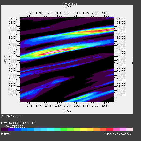
| Thickness Estimate: | 43 km |
| Thickness StdDev: | 0.9 km |
| Vp/Vs Estimate: | 1.79 |
| Vp/Vs StdDev: | 0.03 |
| Vs Estimate: | 3.632 km/s |
| Poisson's Ratio: | 0.27 |
| Peak Value: | 0.07 |
| Assumed Vp: | 6.483 km/s |
| Ps Weight: | 0.33333334 |
| PpPs Weight: | 0.33333334 |
| PsPs Weight: | 0.33333328 |
| Residual Complexity: | 0.727 |
| Nearby stations H: | +- |
| (2.0 deg) Vp/Vs: | +- |
0 with match > 90% ( 0.0 %) and 2 with match > 80% ( 16.666666 %) out of 12.
Download stack as xyz text file.
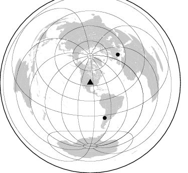
Azimuth Distribution of Events:
Prior Results for this Station
| Study | Thickness | Vp/Vs | Vp | Vs | Poissons Ratio | Extra |
| EARS | 43 km | 1.79 | 6.483 km/s | 3.632 km/s | 0.27 | |
| Crust2.0 | 46 km | 1.78 | 6.483 km/s | 3.648 km/s | 0.27 | D5,thick Platform 2 km seds. |
| Global Maxima | 43 km | 1.79 | 6.483 km/s | 3.632 km/s | 0.27 | amp=0.070629075 |
| Local Maxima 1 | 31 km | 2.10 | 6.483 km/s | 3.091 km/s | 0.35 | amp=0.06140361 |
| Local Maxima 2 | 68 km | 1.93 | 6.483 km/s | 3.363 km/s | 0.32 | amp=0.037923086 |
| Local Maxima 3 | 43 km | 1.72 | 6.483 km/s | 3.78 km/s | 0.24 | amp=0.034450382 |
| Local Maxima 4 | 33 km | 1.93 | 6.483 km/s | 3.359 km/s | 0.32 | amp=0.03220907 |
| Predicted Arrivals for vertical incidence (zero ray parameter) | |
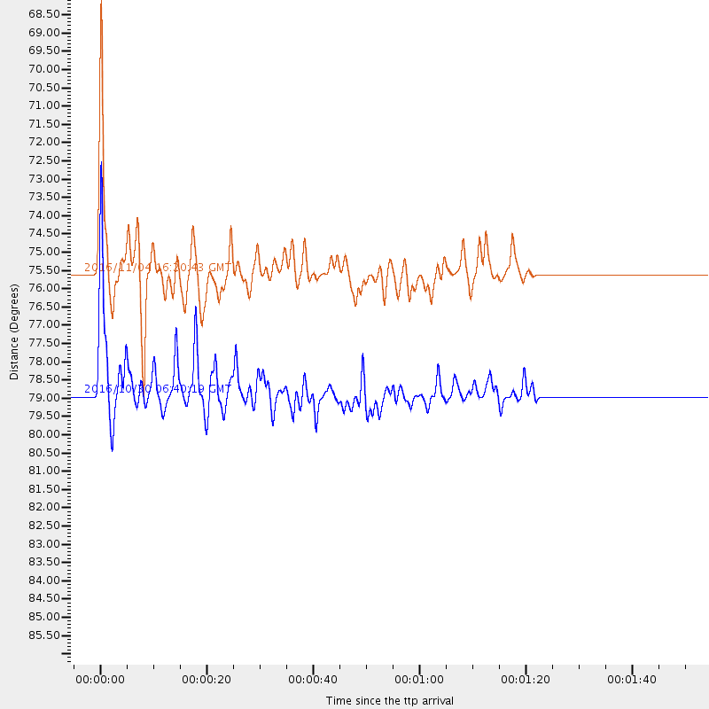
| Ps | 5.24 SECOND |
| PpPs | 18.58 SECOND |
| PsPs/PpSs | 23.82 SECOND |
Events Processed for this Station
Download zip of receiver functions as SAC
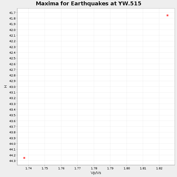
Plot maxima for each earthquake.
Events Used in the Stack
(2 events)| Radial Match | Distance | Baz | FERegion | Time | Lat/Lon | Depth | Magnitude |
| 87.269684 | 78.9 deg | 44.506 deg | Central Italy | 2016/10/30 06:40:19 GMT | (42.9, 13.1) | 10 km | 6.6 MWW, 6.6 MWR |
| 85.32672 | 75.5 deg | 157.689 deg | Chile-Argentina Border Region | 2016/11/04 16:20:43 GMT | (-35.1, -71.0) | 91 km | 6.4 MWP, 6.4 MWW |
Losers
(10 events)| Radial Match | Distance | Baz | FERegion | Time | Lat/Lon | Depth | Magnitude | Reason |
| 57.594692 | 94.3 deg | 243.714 deg | Tonga Islands Region | 2016/10/01 00:33:04 GMT | (-23.7, -174.9) | 35 km | 5.6 MWC, 5.6 MWC | |
| 56.462307 | 97.2 deg | 301.277 deg | Mariana Islands Region | 2016/10/08 18:10:13 GMT | (20.0, 146.8) | 10 km | 5.6 MB, 5.6 MB | |
| 55.374077 | 38.5 deg | 113.993 deg | Leeward Islands | 2016/10/18 22:08:14 GMT | (15.2, -61.5) | 143 km | 5.6 MWW, 5.6 MWB | |
| 54.231297 | 80.0 deg | 318.048 deg | East Of Kuril Islands | 2016/10/23 20:25:26 GMT | (44.0, 148.2) | 30 km | 5.8 MB | |
| 54.050392 | 78.8 deg | 44.536 deg | Central Italy | 2016/10/26 17:10:37 GMT | (42.9, 13.0) | 10 km | 5.5 MWW | |
| 47.309578 | 47.6 deg | 312.671 deg | Unimak Island Region, Alaska | 2016/10/27 11:53:18 GMT | (53.6, -163.3) | 17 km | 5.8 MWP, 5.8 MI | |
| 45.27721 | 72.4 deg | 182.87 deg | Southeast Of Easter Island | 2016/10/08 04:37:41 GMT | (-36.0, -101.0) | 10 km | 5.6 MWC, 5.6 MWC | |
| 45.26965 | 78.8 deg | 44.466 deg | Central Italy | 2016/10/26 19:18:08 GMT | (42.9, 13.0) | 10 km | 6.1 MWW, 6.0 MWB, 6.1 MWR | |
| 41.964256 | 81.4 deg | 47.023 deg | Tyrrhenian Sea | 2016/10/28 20:02:48 GMT | (39.3, 13.5) | 448 km | 5.8 MWW, 5.8 MWB | |
| 32.309235 | 94.7 deg | 248.191 deg | Fiji Islands Region | 2016/11/10 17:35:38 GMT | (-20.4, -178.2) | 546 km | 5.6 MWW |

