
Station YY JAWI - Jawi, Jawi, Ethiopia
Network: YY13 - Exploring extensional tectonics beyond the Ethiopian Rift
Nearby stations (2 deg radius)
| Station | Name | (Lat, Lon) | Start / End | Elevation |
| JAWI | Jawi, Jawi, Ethiopia | (11.57, 36.49) | 2014-04-10 / 2017-12-01 | 1228 m |
| Crust2 Type: | G9,thin custal Archean 0.1 km seds., South American |
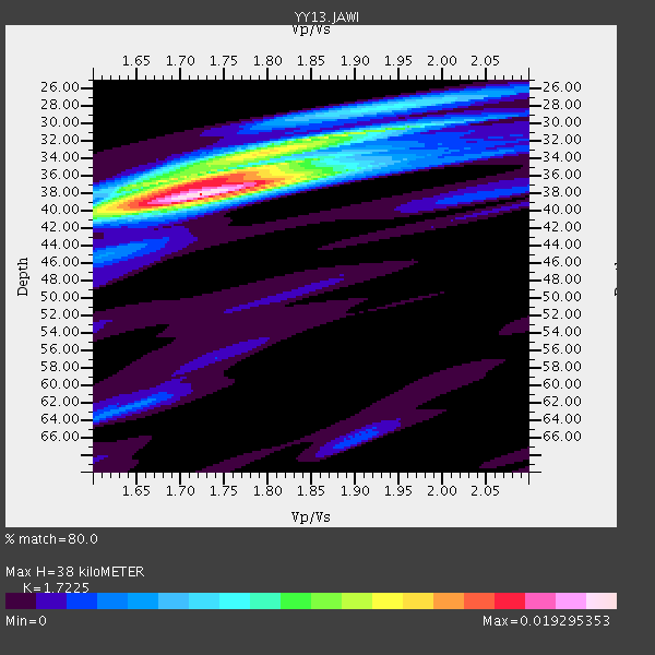
| Thickness Estimate: | 38 km |
| Thickness StdDev: | 1.9 km |
| Vp/Vs Estimate: | 1.72 |
| Vp/Vs StdDev: | 0.05 |
| Vs Estimate: | 3.752 km/s |
| Poisson's Ratio: | 0.25 |
| Peak Value: | 0.02 |
| Assumed Vp: | 6.464 km/s |
| Ps Weight: | 0.33333334 |
| PpPs Weight: | 0.33333334 |
| PsPs Weight: | 0.33333328 |
| Residual Complexity: | 0.579 |
| Nearby stations H: | +- |
| (2.0 deg) Vp/Vs: | +- |
2 with match > 90% ( 11.111111 %) and 6 with match > 80% ( 33.333332 %) out of 18.
Download stack as xyz text file.
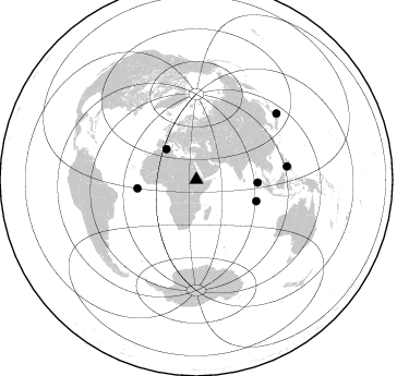
Azimuth Distribution of Events:
Prior Results for this Station
| Study | Thickness | Vp/Vs | Vp | Vs | Poissons Ratio | Extra |
| EARS | 38 km | 1.72 | 6.464 km/s | 3.752 km/s | 0.25 | |
| Crust2.0 | 31 km | 1.76 | 6.464 km/s | 3.663 km/s | 0.26 | G9,thin custal Archean 0.1 km seds., South American |
| Global Maxima | 38 km | 1.72 | 6.464 km/s | 3.752 km/s | 0.25 | amp=0.019295353 |
| Local Maxima 1 | 36 km | 1.74 | 6.464 km/s | 3.715 km/s | 0.25 | amp=0.01167688 |
| Local Maxima 2 | 31 km | 1.91 | 6.464 km/s | 3.384 km/s | 0.31 | amp=0.0092054745 |
| Local Maxima 3 | 37 km | 1.64 | 6.464 km/s | 3.929 km/s | 0.21 | amp=0.006191935 |
| Local Maxima 4 | 28 km | 1.90 | 6.464 km/s | 3.406 km/s | 0.31 | amp=0.005256539 |
| Predicted Arrivals for vertical incidence (zero ray parameter) | |
| Ps | 4.25 SECOND |
| PpPs | 16.01 SECOND |
| PsPs/PpSs | 20.25 SECOND |
Events Processed for this Station
Download zip of receiver functions as SAC
Plot maxima for each earthquake.
Events Used in the Stack
(6 events)| Radial Match | Distance | Baz | FERegion | Time | Lat/Lon | Depth | Magnitude |
| 93.53343 | 95.4 deg | 50.609 deg | Off East Coast Of Honshu, Japan | 2014/07/11 19:22:00 GMT | (37.1, 142.4) | 13 km | 6.8 MWP, 6.8 MI |
| 90.45373 | 58.3 deg | 109.478 deg | South Indian Ocean | 2014/06/14 11:11:00 GMT | (-10.1, 91.1) | 7.1 km | 6.4 MWP, 6.4 MWB |
| 86.45804 | 56.1 deg | 92.631 deg | Off W Coast Of Northern Sumatra | 2014/05/18 01:02:29 GMT | (4.3, 92.7) | 9.8 km | 6.2 MWP |
| 84.62448 | 54.7 deg | 261.753 deg | North Of Ascension Island | 2014/06/30 01:46:23 GMT | (0.0, -17.3) | 8.0 km | 5.8 MB |
| 82.18335 | 84.0 deg | 81.645 deg | Negros, Philippines | 2014/05/15 10:16:46 GMT | (9.4, 122.2) | 53 km | 6.2 MWP |
| 81.09038 | 39.1 deg | 315.697 deg | Northern Algeria | 2014/08/01 04:11:16 GMT | (36.9, 3.2) | 10 km | 5.6 MWP |
Losers
(12 events)| Radial Match | Distance | Baz | FERegion | Time | Lat/Lon | Depth | Magnitude | Reason |
| 79.550995 | 59.4 deg | 67.816 deg | Myanmar-China Border Region | 2014/05/30 01:20:15 GMT | (25.0, 97.9) | 10 km | 5.9 MB | |
| 76.855865 | 97.2 deg | 41.775 deg | Kuril Islands | 2014/07/20 18:32:47 GMT | (44.6, 148.7) | 61 km | 6.6 MB | |
| 72.7094 | 85.0 deg | 208.879 deg | South Sandwich Islands Region | 2014/05/19 22:47:12 GMT | (-57.0, -25.1) | 10 km | 5.7 MWW, 5.7 MWC | |
| 66.965515 | 93.7 deg | 53.437 deg | Near S. Coast Of Honshu, Japan | 2014/05/04 20:18:25 GMT | (34.9, 139.3) | 156 km | 5.8 MB | |
| 65.554115 | 80.9 deg | 67.604 deg | Taiwan | 2014/05/21 00:21:13 GMT | (23.7, 121.5) | 12 km | 5.6 MB | |
| 64.9997 | 85.7 deg | 86.295 deg | Celebes Sea | 2014/04/17 04:38:17 GMT | (4.5, 123.0) | 567 km | 5.5 MWP | |
| 60.890087 | 39.5 deg | 45.42 deg | Hindu Kush Region, Afghanistan | 2014/06/14 03:58:41 GMT | (36.5, 70.7) | 200 km | 5.6 MWW, 5.6 MWB, 5.6 MWC | |
| 48.387768 | 94.4 deg | 48.22 deg | Near East Coast Of Honshu, Japan | 2014/07/04 22:42:04 GMT | (39.7, 142.0) | 45 km | 5.7 MB | |
| 46.752895 | 55.1 deg | 80.455 deg | Andaman Islands, India Region | 2014/07/29 07:07:07 GMT | (14.4, 93.1) | 10 km | 5.5 MB | |
| 43.98946 | 88.7 deg | 85.848 deg | Talaud Islands, Indonesia | 2014/05/30 01:33:24 GMT | (4.4, 126.1) | 55 km | 4.3 mb | |
| 41.541595 | 76.3 deg | 102.536 deg | South Of Java, Indonesia | 2014/04/18 15:07:10 GMT | (-9.2, 110.3) | 35 km | 5.0 mb | |
| 35.907265 | 92.9 deg | 45.519 deg | Hokkaido, Japan Region | 2014/07/08 09:05:23 GMT | (42.7, 141.4) | 10 km | 5.6 MB, 5.5 MWB |

