
Station Z9 D04 - Amason Farm, Lincolnton, GA
Network: Z910 - Southeastern Suture of the Appalachian Margin Experiment
Nearby stations (2 deg radius)
| Station | Name | (Lat, Lon) | Start / End | Elevation |
| D04 | Amason Farm, Lincolnton, GA | (33.73, -82.45) | 2012-05-15 / 2014-05-19 | 128 m |
| Crust2 Type: | DG,thin Platform 1 km seds. |
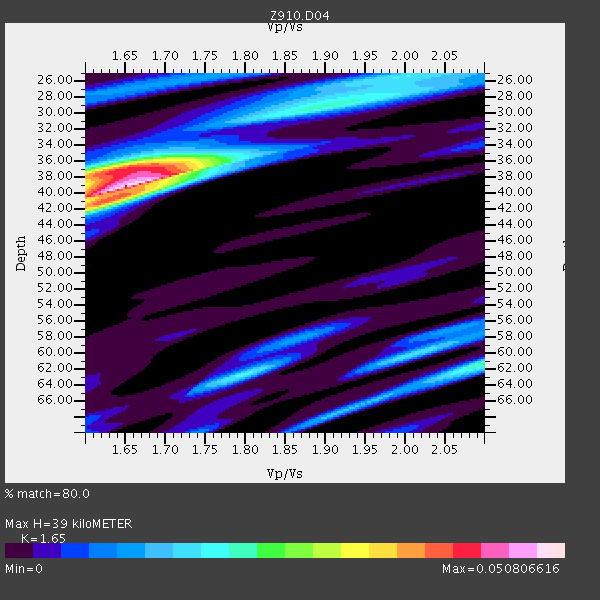
| Thickness Estimate: | 39 km |
| Thickness StdDev: | 2.1 km |
| Vp/Vs Estimate: | 1.65 |
| Vp/Vs StdDev: | 0.04 |
| Vs Estimate: | 3.978 km/s |
| Poisson's Ratio: | 0.21 |
| Peak Value: | 0.05 |
| Assumed Vp: | 6.565 km/s |
| Ps Weight: | 0.33333334 |
| PpPs Weight: | 0.33333334 |
| PsPs Weight: | 0.33333328 |
| Residual Complexity: | 0.697 |
| Nearby stations H: | +- |
| (2.0 deg) Vp/Vs: | +- |
2 with match > 90% ( 8.0 %) and 3 with match > 80% ( 12.0 %) out of 25.
Download stack as xyz text file.
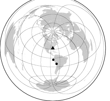
Azimuth Distribution of Events:
Prior Results for this Station
| Study | Thickness | Vp/Vs | Vp | Vs | Poissons Ratio | Extra |
| EARS | 39 km | 1.65 | 6.565 km/s | 3.978 km/s | 0.21 | |
| Crust2.0 | 31 km | 1.78 | 6.565 km/s | 3.684 km/s | 0.27 | DG,thin Platform 1 km seds. |
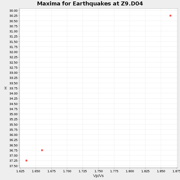
| Global Maxima | 39 km | 1.65 | 6.565 km/s | 3.978 km/s | 0.21 | amp=0.050806616 |
| Local Maxima 1 | 37 km | 1.64 | 6.565 km/s | 4.009 km/s | 0.20 | amp=0.035434034 |
| Local Maxima 2 | 61 km | 2.10 | 6.565 km/s | 3.13 km/s | 0.35 | amp=0.023080328 |
| Local Maxima 3 | 41 km | 1.63 | 6.565 km/s | 4.033 km/s | 0.20 | amp=0.020647591 |
| Local Maxima 4 | 29 km | 1.91 | 6.565 km/s | 3.432 km/s | 0.31 | amp=0.018917305 |
| Predicted Arrivals for vertical incidence (zero ray parameter) | |
| Ps | 3.86 SECOND |
| PpPs | 15.74 SECOND |
| PsPs/PpSs | 19.61 SECOND |
Events Processed for this Station
Download zip of receiver functions as SAC
Plot maxima for each earthquake.
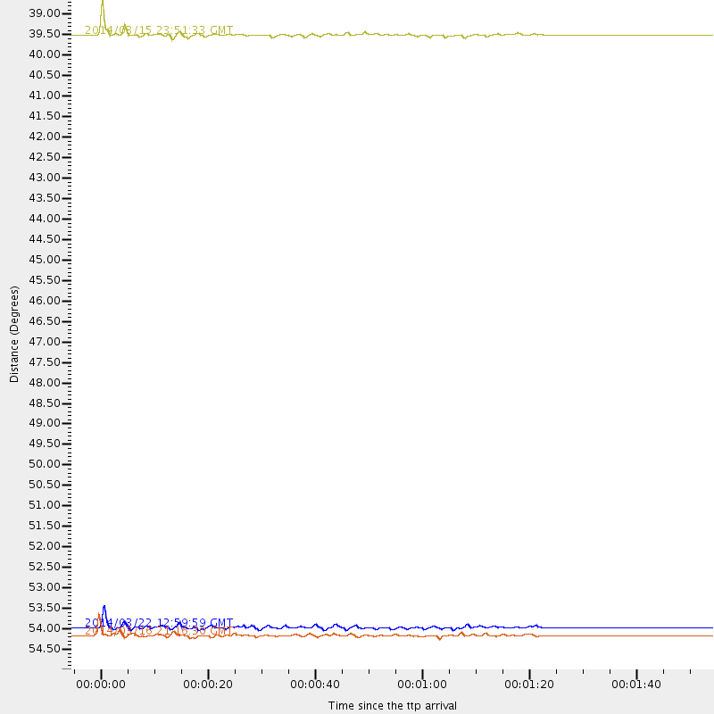
Events Used in the Stack
(3 events)| Radial Match | Distance | Baz | FERegion | Time | Lat/Lon | Depth | Magnitude |
| 94.26586 | 54.5 deg | 166.307 deg | Near Coast Of Northern Chile | 2014/03/16 21:16:30 GMT | (-19.9, -70.6) | 20 km | 6.7 MWW, 6.7 MWC, 7.0 MI |
| 90.838524 | 54.3 deg | 166.545 deg | Near Coast Of Northern Chile | 2014/03/22 12:59:59 GMT | (-19.8, -70.9) | 20 km | 6.2 MWW, 6.2 MWB, 6.3 MWC, 6.4 MWC |
| 88.6345 | 39.1 deg | 177.641 deg | Near Coast Of Northern Peru | 2014/03/15 23:51:33 GMT | (-5.6, -81.0) | 29 km | 6.3 MWW, 6.2 MWB, 6.3 MWC |
Losers
(22 events)| Radial Match | Distance | Baz | FERegion | Time | Lat/Lon | Depth | Magnitude | Reason |
| 90.491844 | 34.4 deg | 294.5 deg | Off Coast Of Northern California | 2014/03/10 05:18:13 GMT | (40.8, -125.1) | 17 km | 6.8 MW, 6.8 MWR, 6.9 MWW, 6.9 MWB, 7.0 MI, 7.0 MWC | |
| 83.63448 | 54.2 deg | 165.671 deg | Near Coast Of Northern Chile | 2014/04/01 23:59:57 GMT | (-19.5, -70.2) | 22 km | 5.8 MB | |
| 74.130936 | 87.6 deg | 326.331 deg | Kuril Islands | 2014/01/17 05:22:39 GMT | (45.9, 150.0) | 200 km | 3.7 mb | |
| 73.38299 | 47.9 deg | 171.958 deg | Near Coast Of Peru | 2014/03/15 08:59:21 GMT | (-14.1, -76.3) | 20 km | 6.1 MWW, 6.0 MWB, 6.2 MWC | |
| 71.332 | 48.1 deg | 171.054 deg | Near Coast Of Peru | 2014/02/18 23:35:58 GMT | (-14.2, -75.6) | 57 km | 6.0 MWB, 5.9 MWW, 5.9 MWC, 6.0 MWC | |
| 71.020164 | 54.2 deg | 166.45 deg | Near Coast Of Northern Chile | 2014/04/01 23:46:46 GMT | (-19.6, -70.8) | 20 km | 8.2 MWW, 8.0 MI, 8.1 MWC | |
| 70.51311 | 54.7 deg | 166.51 deg | Near Coast Of Northern Chile | 2014/03/17 05:24:07 GMT | (-20.1, -70.8) | 10 km | 4.6 mb | |
| 67.05118 | 54.3 deg | 166.468 deg | Near Coast Of Northern Chile | 2014/03/23 18:20:03 GMT | (-19.7, -70.8) | 35 km | 6.0 MB, 6.2 MWB, 6.2 MWW, 6.3 MWC | |
| 61.33515 | 33.6 deg | 92.385 deg | Northern Mid-Atlantic Ridge | 2014/01/18 22:19:28 GMT | (26.3, -44.4) | 11 km | 5.4 MW | |
| 61.0784 | 63.3 deg | 318.163 deg | Fox Islands, Aleutian Islands | 2014/02/26 21:13:40 GMT | (53.6, -171.8) | 265 km | 6.1 MWW, 5.9 MI, 5.9 ML, 6.1 MWC, 6.1 MWB, 6.2 MWC | |
| 59.64244 | 54.3 deg | 166.679 deg | Near Coast Of Northern Chile | 2014/03/22 22:14:57 GMT | (-19.7, -71.0) | 19 km | 5.1 MW | |
| 59.29293 | 54.4 deg | 166.521 deg | Near Coast Of Northern Chile | 2014/03/23 20:23:04 GMT | (-19.9, -70.8) | 23 km | 5.3 MW | |
| 57.381084 | 39.2 deg | 177.637 deg | Near Coast Of Northern Peru | 2014/03/22 00:38:45 GMT | (-5.6, -81.0) | 37 km | 4.9 mb | |
| 56.89641 | 68.4 deg | 317.761 deg | Andreanof Islands, Aleutian Is. | 2014/01/16 07:33:09 GMT | (51.2, -179.2) | 27 km | 5.5 MWB, 5.2 ML, 5.5 ML, 5.6 MWC | |
| 53.701794 | 54.4 deg | 166.566 deg | Near Coast Of Northern Chile | 2014/04/02 00:03:12 GMT | (-19.8, -70.9) | 10 km | 5.8 MB | |
| 49.89848 | 55.3 deg | 166.52 deg | Near Coast Of Northern Chile | 2014/01/06 03:59:02 GMT | (-20.7, -70.6) | 27 km | 5.2 MW | |
| 47.04793 | 85.7 deg | 325.979 deg | Kuril Islands | 2014/01/15 10:25:14 GMT | (47.1, 152.3) | 107 km | 4.5 mb | |
| 46.34162 | 55.6 deg | 158.653 deg | Southern Bolivia | 2014/01/27 16:42:37 GMT | (-19.3, -63.9) | 600 km | 5.6 MWB | |
| 45.982323 | 54.4 deg | 166.508 deg | Near Coast Of Northern Chile | 2014/03/24 11:40:44 GMT | (-19.8, -70.8) | 23 km | 5.5 MB, 5.5 MWR, 5.6 MWW, 5.7 MWC | |
| 40.187904 | 53.4 deg | 164.492 deg | Northern Chile | 2014/01/29 10:01:50 GMT | (-18.5, -69.4) | 120 km | 5.6 MWW, 5.6 MWB, 5.7 MWC | |
| 39.92365 | 81.7 deg | 328.96 deg | Northwest Of Kuril Islands | 2014/03/12 18:18:40 GMT | (52.0, 153.2) | 418 km | 5.1 MW | |
| 36.635147 | 54.4 deg | 166.456 deg | Near Coast Of Northern Chile | 2014/03/24 11:32:15 GMT | (-19.8, -70.8) | 24 km | 5.3 MW |

