
Station Z9 D05 - Bedrock Farms, Lincolnton, GA
Network: Z910 - Southeastern Suture of the Appalachian Margin Experiment
Nearby stations (2 deg radius)
| Station | Name | (Lat, Lon) | Start / End | Elevation |
| D05 | Bedrock Farms, Lincolnton, GA | (33.79, -82.52) | 2011-05-18 / 2014-05-19 | 146 m |
| Crust2 Type: | DG,thin Platform 1 km seds. |
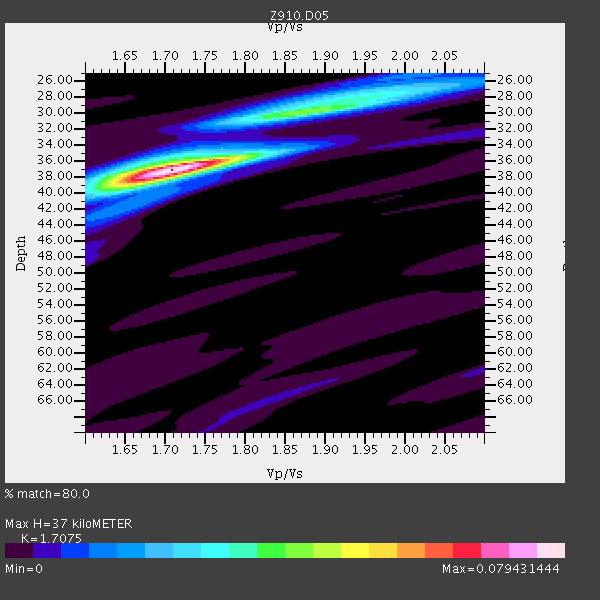
| Thickness Estimate: | 37 km |
| Thickness StdDev: | 0.8 km |
| Vp/Vs Estimate: | 1.71 |
| Vp/Vs StdDev: | 0.02 |
| Vs Estimate: | 3.845 km/s |
| Poisson's Ratio: | 0.24 |
| Peak Value: | 0.08 |
| Assumed Vp: | 6.565 km/s |
| Ps Weight: | 0.33333334 |
| PpPs Weight: | 0.33333334 |
| PsPs Weight: | 0.33333328 |
| Residual Complexity: | 0.481 |
| Nearby stations H: | +- |
| (2.0 deg) Vp/Vs: | +- |
5 with match > 90% ( 12.5 %) and 7 with match > 80% ( 17.5 %) out of 40.
Download stack as xyz text file.
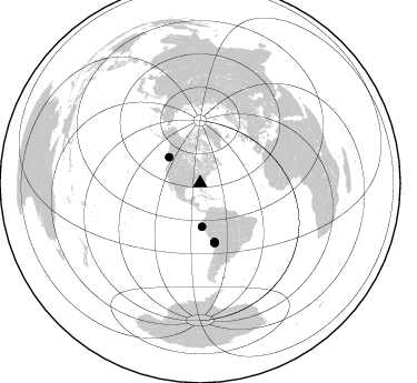
Azimuth Distribution of Events:
Prior Results for this Station
| Study | Thickness | Vp/Vs | Vp | Vs | Poissons Ratio | Extra |
| EARS | 37 km | 1.71 | 6.565 km/s | 3.845 km/s | 0.24 | |
| Crust2.0 | 31 km | 1.78 | 6.565 km/s | 3.684 km/s | 0.27 | DG,thin Platform 1 km seds. |
| Global Maxima | 37 km | 1.71 | 6.565 km/s | 3.845 km/s | 0.24 | amp=0.079431444 |
| Local Maxima 1 | 30 km | 1.89 | 6.565 km/s | 3.478 km/s | 0.30 | amp=0.039415605 |
| Local Maxima 2 | 28 km | 1.97 | 6.565 km/s | 3.328 km/s | 0.33 | amp=0.019570198 |
| Local Maxima 3 | 39 km | 1.67 | 6.565 km/s | 3.937 km/s | 0.22 | amp=0.014508119 |
| Local Maxima 4 | 36 km | 1.68 | 6.565 km/s | 3.902 km/s | 0.23 | amp=0.011253096 |
| Predicted Arrivals for vertical incidence (zero ray parameter) | |
| Ps | 3.99 SECOND |
| PpPs | 15.26 SECOND |
| PsPs/PpSs | 19.25 SECOND |
Events Processed for this Station
Download zip of receiver functions as SAC
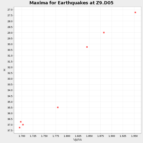
Plot maxima for each earthquake.
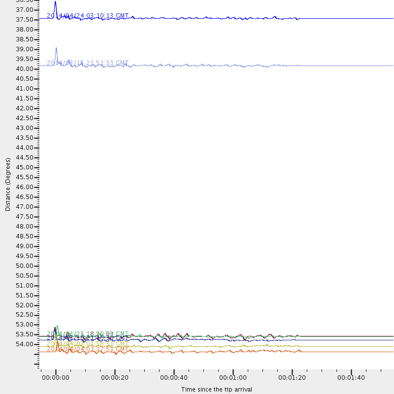
Events Used in the Stack
(7 events)| Radial Match | Distance | Baz | FERegion | Time | Lat/Lon | Depth | Magnitude |
| 95.73781 | 55.0 deg | 166.253 deg | Near Coast Of Northern Chile | 2014/04/03 01:58:31 GMT | (-20.3, -70.6) | 23 km | 6.5 MWW, 6.5 MWB, 6.6 MWC |
| 95.13779 | 36.5 deg | 309.812 deg | Vancouver Island, Canada Region | 2014/04/24 03:10:13 GMT | (49.8, -127.4) | 11 km | 6.7 MWP, 6.7 MI |
| 92.96783 | 54.6 deg | 166.245 deg | Near Coast Of Northern Chile | 2014/03/16 21:16:30 GMT | (-19.9, -70.6) | 20 km | 6.7 MWW, 6.7 MWC, 7.0 MI |
| 91.38474 | 54.4 deg | 166.483 deg | Near Coast Of Northern Chile | 2014/03/22 12:59:59 GMT | (-19.8, -70.9) | 20 km | 6.2 MWW, 6.2 MWB, 6.3 MWC, 6.4 MWC |
| 90.60837 | 39.2 deg | 177.543 deg | Near Coast Of Northern Peru | 2014/03/15 23:51:33 GMT | (-5.6, -81.0) | 29 km | 6.3 MWW, 6.2 MWB, 6.3 MWC |
| 87.88425 | 55.3 deg | 166.547 deg | Near Coast Of Northern Chile | 2014/04/04 01:37:51 GMT | (-20.6, -70.7) | 20 km | 6.1 MWP, 6.1 MWB, 6.1 MWW, 6.3 MWC |
| 83.9484 | 54.4 deg | 166.406 deg | Near Coast Of Northern Chile | 2014/03/23 18:20:03 GMT | (-19.7, -70.8) | 35 km | 6.0 MB, 6.2 MWB, 6.2 MWW, 6.3 MWC |
Losers
(33 events)| Radial Match | Distance | Baz | FERegion | Time | Lat/Lon | Depth | Magnitude | Reason |
| 98.770805 | 54.3 deg | 166.387 deg | Near Coast Of Northern Chile | 2014/04/01 23:46:46 GMT | (-19.6, -70.8) | 20 km | 8.2 MWW, 8.0 MI, 8.1 MWC | |
| 96.97081 | 55.2 deg | 166.252 deg | Near Coast Of Northern Chile | 2014/04/03 02:43:14 GMT | (-20.5, -70.5) | 31 km | 7.7 MWW, 7.4 MI, 7.7 MWC | |
| 92.82257 | 34.4 deg | 294.416 deg | Off Coast Of Northern California | 2014/03/10 05:18:13 GMT | (40.8, -125.1) | 17 km | 6.8 MW, 6.8 MWR, 6.9 MWW, 6.9 MWB, 7.0 MI, 7.0 MWC | |
| 83.9952 | 54.3 deg | 165.61 deg | Near Coast Of Northern Chile | 2014/04/01 23:59:57 GMT | (-19.5, -70.2) | 22 km | 5.8 MB | |
| 82.12996 | 51.4 deg | 322.922 deg | Southern Alaska | 2014/05/10 14:16:08 GMT | (60.0, -152.2) | 96 km | 5.8 ML, 5.5 MI, 5.7 MWP | |
| 78.93743 | 48.0 deg | 171.883 deg | Near Coast Of Peru | 2014/03/15 08:59:21 GMT | (-14.1, -76.3) | 20 km | 6.1 MWW, 6.0 MWB, 6.2 MWC | |
| 75.199425 | 55.5 deg | 166.382 deg | Near Coast Of Northern Chile | 2014/04/03 05:26:16 GMT | (-20.8, -70.5) | 24 km | 6.2 MWP, 6.2 MWR, 6.3 MWW, 6.5 MWC | |
| 73.0844 | 48.1 deg | 170.979 deg | Near Coast Of Peru | 2014/02/18 23:35:58 GMT | (-14.2, -75.6) | 57 km | 6.0 MWB, 5.9 MWW, 5.9 MWC, 6.0 MWC | |
| 68.332405 | 66.7 deg | 51.113 deg | France | 2014/04/07 19:27:00 GMT | (44.5, 6.7) | 9.1 km | 5.0 MW | |
| 67.43734 | 66.4 deg | 108.058 deg | Central Mid-Atlantic Ridge | 2014/03/29 07:46:50 GMT | (-0.8, -21.9) | 12 km | 5.9 MWW, 5.8 MWB, 6.0 MWC | |
| 67.412506 | 54.7 deg | 166.448 deg | Near Coast Of Northern Chile | 2014/03/17 05:24:07 GMT | (-20.1, -70.8) | 10 km | 4.6 mb | |
| 65.7857 | 55.4 deg | 332.758 deg | Northern Alaska | 2014/05/03 08:57:12 GMT | (67.6, -162.2) | 0.9 km | 5.5 MB | |
| 64.16534 | 55.2 deg | 166.496 deg | Near Coast Of Northern Chile | 2014/04/03 09:23:21 GMT | (-20.6, -70.7) | 15 km | 5.6 MB, 5.3 MWR | |
| 62.603424 | 69.0 deg | 350.4 deg | Laptev Sea | 2014/04/11 13:27:05 GMT | (74.9, 133.8) | 10 km | 4.2 mb | |
| 62.446983 | 54.8 deg | 166.555 deg | Near Coast Of Northern Chile | 2014/04/02 04:46:18 GMT | (-20.2, -70.9) | 10 km | 5.8 MB | |
| 62.32688 | 63.2 deg | 318.127 deg | Fox Islands, Aleutian Islands | 2014/02/26 21:13:40 GMT | (53.6, -171.8) | 265 km | 6.1 MWW, 5.9 MI, 5.9 ML, 6.1 MWC, 6.1 MWB, 6.2 MWC | |
| 62.159195 | 83.0 deg | 329.604 deg | Sea Of Okhotsk | 2014/01/15 06:55:09 GMT | (51.5, 151.0) | 551 km | 4.6 mb | |
| 61.30937 | 54.6 deg | 166.35 deg | Near Coast Of Northern Chile | 2014/03/17 08:32:37 GMT | (-20.0, -70.7) | 15 km | 5.1 MW | |
| 58.70965 | 53.9 deg | 166.497 deg | Near Coast Of Northern Chile | 2014/05/05 09:02:55 GMT | (-19.3, -71.0) | 21 km | 4.9 MW | |
| 55.442112 | 68.4 deg | 317.725 deg | Andreanof Islands, Aleutian Is. | 2014/01/16 07:33:09 GMT | (51.2, -179.2) | 27 km | 5.5 MWB, 5.2 ML, 5.5 ML, 5.6 MWC | |
| 52.291634 | 68.3 deg | 317.726 deg | Andreanof Islands, Aleutian Is. | 2014/03/13 13:20:59 GMT | (51.2, -179.1) | 26 km | 5.6 MWC, 5.1 ML, 5.4 MWW, 5.4 MWB, 5.5 ML, 5.6 MWC | |
| 51.478115 | 55.7 deg | 158.599 deg | Southern Bolivia | 2014/01/27 16:42:37 GMT | (-19.3, -63.9) | 600 km | 5.6 MWB | |
| 50.10478 | 55.5 deg | 332.862 deg | Northern Alaska | 2014/04/18 18:56:47 GMT | (67.7, -162.5) | 17 km | 5.7 MW | |
| 47.804157 | 54.5 deg | 164.499 deg | Northern Chile | 2014/03/31 12:53:05 GMT | (-19.5, -69.2) | 112 km | 5.6 MB, 5.5 MWB, 5.6 MWC, 5.6 MWW | |
| 47.63876 | 72.7 deg | 322.572 deg | Near Islands, Aleutian Islands | 2014/04/07 07:48:29 GMT | (53.0, 171.0) | 26 km | 5.2 MW | |
| 47.309204 | 36.5 deg | 299.442 deg | Off Coast Of Oregon | 2014/05/12 18:51:00 GMT | (43.7, -128.1) | 14 km | 5.5 MW | |
| 43.281513 | 97.0 deg | 152.204 deg | South Georgia Island Region | 2014/03/17 13:24:48 GMT | (-53.2, -32.3) | 5.4 km | 5.6 MB, 5.8 MWB, 5.9 MWC | |
| 41.991203 | 54.8 deg | 166.574 deg | Near Coast Of Northern Chile | 2014/04/07 13:43:20 GMT | (-20.2, -70.9) | 7.9 km | 5.8 MWB, 5.7 MWW, 5.7 MWC | |
| 41.58914 | 81.5 deg | 50.763 deg | Southern Greece | 2014/04/04 20:08:07 GMT | (37.2, 23.8) | 107 km | 5.5 MWB, 5.5 MWR, 5.6 MWC, 5.6 MWW | |
| 39.323997 | 81.4 deg | 326.377 deg | Kuril Islands | 2014/04/07 09:34:49 GMT | (50.4, 156.3) | 85 km | 5.2 MW | |
| 37.861076 | 54.3 deg | 166.377 deg | Near Coast Of Northern Chile | 2014/03/24 15:45:31 GMT | (-19.6, -70.8) | 18 km | 5.6 MWB, 5.5 MWR, 5.7 MWC, 5.7 MWW | |
| 37.277058 | 67.0 deg | 170.007 deg | Near Coast Of Central Chile | 2014/04/05 02:22:38 GMT | (-32.8, -71.6) | 40 km | 5.6 MWC, 5.6 MWC | |
| 34.786194 | 55.1 deg | 166.73 deg | Near Coast Of Northern Chile | 2014/04/08 10:14:32 GMT | (-20.5, -70.9) | 7.1 km | 5.7 MWB, 5.5 MWR, 5.6 MWC, 5.6 MWW |

