
Station Z9 D06 - Smith Farm, Washington, GA
Network: Z910 - Southeastern Suture of the Appalachian Margin Experiment
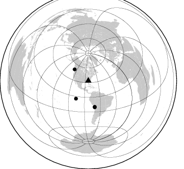
Nearby stations (2 deg radius)
| Station | Name | (Lat, Lon) | Start / End | Elevation |
| D06 | Smith Farm, Washington, GA | (33.86, -82.63) | 2012-05-04 / 2014-05-19 | 152 m |
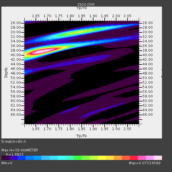
| Crust2 Type: | DG,thin Platform 1 km seds. |
| Thickness Estimate: | 38 km |
| Thickness StdDev: | 2.6 km |
| Vp/Vs Estimate: | 1.68 |
| Vp/Vs StdDev: | 0.06 |
| Vs Estimate: | 3.902 km/s |
| Poisson's Ratio: | 0.23 |
| Peak Value: | 0.07 |
| Assumed Vp: | 6.565 km/s |
| Ps Weight: | 0.33333334 |
| PpPs Weight: | 0.33333334 |
| PsPs Weight: | 0.33333328 |
| Residual Complexity: | 0.552 |
| Nearby stations H: | +- |
| (2.0 deg) Vp/Vs: | +- |
2 with match > 90% ( 6.060606 %) and 5 with match > 80% ( 15.151515 %) out of 33.
Download stack as xyz text file.
Azimuth Distribution of Events:
Prior Results for this Station
| Study | Thickness | Vp/Vs | Vp | Vs | Poissons Ratio | Extra |
| EARS | 38 km | 1.68 | 6.565 km/s | 3.902 km/s | 0.23 | |
| Crust2.0 | 31 km | 1.78 | 6.565 km/s | 3.684 km/s | 0.27 | DG,thin Platform 1 km seds. |
| Global Maxima | 38 km | 1.68 | 6.565 km/s | 3.902 km/s | 0.23 | amp=0.07334589 |
| Local Maxima 1 | 30 km | 1.84 | 6.565 km/s | 3.573 km/s | 0.29 | amp=0.04264987 |
| Local Maxima 2 | 40 km | 1.63 | 6.565 km/s | 4.015 km/s | 0.20 | amp=0.02451828 |
| Local Maxima 3 | 38 km | 1.65 | 6.565 km/s | 3.985 km/s | 0.21 | amp=0.017700098 |
| Local Maxima 4 | 28 km | 1.91 | 6.565 km/s | 3.432 km/s | 0.31 | amp=0.011830853 |
| Predicted Arrivals for vertical incidence (zero ray parameter) | |
| Ps | 3.95 SECOND |
| PpPs | 15.53 SECOND |
| PsPs/PpSs | 19.48 SECOND |
Events Processed for this Station
Download zip of receiver functions as SAC
Plot maxima for each earthquake.
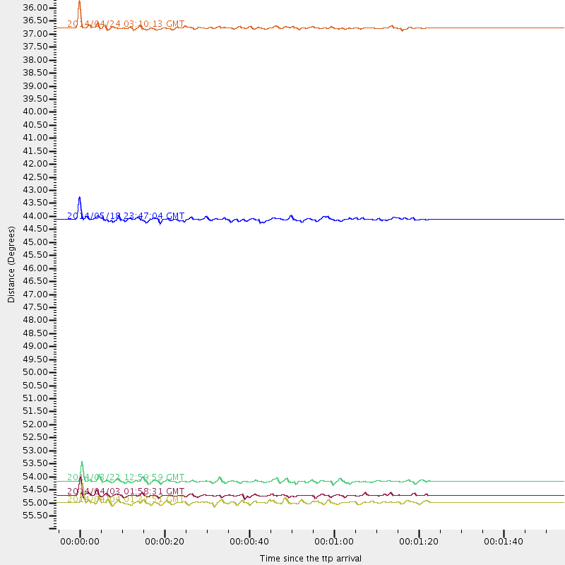
Events Used in the Stack
(5 events)| Radial Match | Distance | Baz | FERegion | Time | Lat/Lon | Depth | Magnitude |
| 95.54861 | 36.4 deg | 309.761 deg | Vancouver Island, Canada Region | 2014/04/24 03:10:13 GMT | (49.8, -127.4) | 11 km | 6.7 MWP, 6.7 MI |
| 94.73896 | 55.0 deg | 166.136 deg | Near Coast Of Northern Chile | 2014/04/03 01:58:31 GMT | (-20.3, -70.6) | 23 km | 6.5 MWW, 6.5 MWB, 6.6 MWC |
| 89.27726 | 55.3 deg | 166.431 deg | Near Coast Of Northern Chile | 2014/04/04 01:37:51 GMT | (-20.6, -70.7) | 20 km | 6.1 MWP, 6.1 MWB, 6.1 MWW, 6.3 MWC |
| 89.178444 | 54.5 deg | 166.364 deg | Near Coast Of Northern Chile | 2014/03/22 12:59:59 GMT | (-19.8, -70.9) | 20 km | 6.2 MWW, 6.2 MWB, 6.3 MWC, 6.4 MWC |
| 83.26652 | 44.1 deg | 214.699 deg | Central East Pacific Rise | 2014/05/18 23:47:04 GMT | (-4.5, -106.0) | 17 km | 5.9 MW |
Losers
(28 events)| Radial Match | Distance | Baz | FERegion | Time | Lat/Lon | Depth | Magnitude | Reason |
| 98.82976 | 54.4 deg | 166.269 deg | Near Coast Of Northern Chile | 2014/04/01 23:46:46 GMT | (-19.6, -70.8) | 20 km | 8.2 MWW, 8.0 MI, 8.1 MWC | |
| 97.629036 | 55.3 deg | 166.135 deg | Near Coast Of Northern Chile | 2014/04/03 02:43:14 GMT | (-20.5, -70.5) | 31 km | 7.7 MWW, 7.4 MI, 7.7 MWC | |
| 94.50023 | 34.2 deg | 294.32 deg | Off Coast Of Northern California | 2014/03/10 05:18:13 GMT | (40.8, -125.1) | 17 km | 6.8 MW, 6.8 MWR, 6.9 MWW, 6.9 MWB, 7.0 MI, 7.0 MWC | |
| 86.611755 | 51.3 deg | 322.886 deg | Southern Alaska | 2014/05/10 14:16:08 GMT | (60.0, -152.2) | 96 km | 5.8 ML, 5.5 MI, 5.7 MWP | |
| 83.39953 | 54.4 deg | 165.492 deg | Near Coast Of Northern Chile | 2014/04/01 23:59:57 GMT | (-19.5, -70.2) | 22 km | 5.8 MB | |
| 81.42709 | 55.6 deg | 166.266 deg | Near Coast Of Northern Chile | 2014/04/03 05:26:16 GMT | (-20.8, -70.5) | 24 km | 6.2 MWP, 6.2 MWR, 6.3 MWW, 6.5 MWC | |
| 76.65107 | 54.5 deg | 166.288 deg | Near Coast Of Northern Chile | 2014/03/23 18:20:03 GMT | (-19.7, -70.8) | 35 km | 6.0 MB, 6.2 MWB, 6.2 MWW, 6.3 MWC | |
| 75.06208 | 88.2 deg | 200.044 deg | Southern East Pacific Rise | 2014/05/12 18:38:37 GMT | (-50.0, -114.7) | 8.2 km | 5.8 MB | |
| 73.53455 | 55.3 deg | 332.732 deg | Northern Alaska | 2014/05/03 08:57:12 GMT | (67.6, -162.2) | 0.9 km | 5.5 MB | |
| 71.5512 | 54.8 deg | 166.132 deg | Near Coast Of Northern Chile | 2014/04/02 00:37:49 GMT | (-20.0, -70.6) | 20 km | 5.4 mb | |
| 70.94131 | 58.5 deg | 164.847 deg | Northern Chile | 2014/05/16 17:08:32 GMT | (-23.5, -68.6) | 103 km | 5.5 MWR | |
| 67.91205 | 63.1 deg | 318.076 deg | Fox Islands, Aleutian Islands | 2014/02/26 21:13:40 GMT | (53.6, -171.8) | 265 km | 6.1 MWW, 5.9 MI, 5.9 ML, 6.1 MWC, 6.1 MWB, 6.2 MWC | |
| 61.90412 | 58.9 deg | 165.649 deg | Northern Chile | 2014/03/20 18:41:32 GMT | (-24.0, -69.2) | 96 km | 5.1 MW | |
| 61.73967 | 93.8 deg | 327.982 deg | Hokkaido, Japan Region | 2014/01/09 04:31:54 GMT | (42.1, 142.7) | 64 km | 4.8 MW | |
| 60.81862 | 54.9 deg | 166.456 deg | Near Coast Of Northern Chile | 2014/04/07 13:43:20 GMT | (-20.2, -70.9) | 7.9 km | 5.8 MWB, 5.7 MWW, 5.7 MWC | |
| 57.020367 | 55.3 deg | 166.379 deg | Near Coast Of Northern Chile | 2014/04/03 09:23:21 GMT | (-20.6, -70.7) | 15 km | 5.6 MB, 5.3 MWR | |
| 56.093327 | 72.5 deg | 322.519 deg | Near Islands, Aleutian Islands | 2014/04/07 07:48:29 GMT | (53.0, 171.0) | 26 km | 5.2 MW | |
| 55.80882 | 55.3 deg | 166.425 deg | Near Coast Of Northern Chile | 2014/04/13 12:11:30 GMT | (-20.6, -70.7) | 13 km | 5.5 MWW, 5.3 MWR | |
| 55.02941 | 54.6 deg | 166.341 deg | Near Coast Of Northern Chile | 2014/03/23 20:23:04 GMT | (-19.9, -70.8) | 23 km | 5.3 MW | |
| 53.43193 | 84.2 deg | 326.342 deg | Kuril Islands | 2014/04/03 10:26:01 GMT | (48.4, 153.2) | 159 km | 4.2 mb | |
| 51.367252 | 36.4 deg | 299.362 deg | Off Coast Of Oregon | 2014/05/12 18:51:00 GMT | (43.7, -128.1) | 14 km | 5.5 MW | |
| 50.50886 | 55.8 deg | 158.492 deg | Southern Bolivia | 2014/01/27 16:42:37 GMT | (-19.3, -63.9) | 600 km | 5.6 MWB | |
| 50.04751 | 54.9 deg | 166.312 deg | Near Coast Of Northern Chile | 2014/05/05 11:21:19 GMT | (-20.2, -70.7) | 24 km | 5.4 MW | |
| 49.669518 | 71.0 deg | 191.977 deg | West Chile Rise | 2014/05/06 20:52:29 GMT | (-36.3, -96.7) | 14 km | 5.9 MWB | |
| 48.729553 | 55.2 deg | 166.191 deg | Near Coast Of Northern Chile | 2014/04/02 19:45:49 GMT | (-20.4, -70.6) | 17 km | 5.3 MW | |
| 48.071682 | 54.9 deg | 166.32 deg | Near Coast Of Northern Chile | 2014/04/15 16:21:17 GMT | (-20.2, -70.7) | 18 km | 5.1 MW | |
| 37.102688 | 73.4 deg | 102.985 deg | North Of Ascension Island | 2014/04/30 15:52:42 GMT | (-1.2, -13.5) | 14 km | 5.8 MW | |
| 25.726238 | 83.9 deg | 325.754 deg | Kuril Islands | 2014/01/10 18:03:00 GMT | (48.2, 154.1) | 82 km | 5.1 MW |

