
Station Z9 D09 - Scarborough Farm, Elberton, GA
Network: Z910 - Southeastern Suture of the Appalachian Margin Experiment
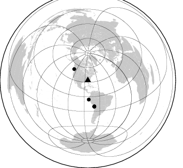
Nearby stations (2 deg radius)
| Station | Name | (Lat, Lon) | Start / End | Elevation |
| D09 | Scarborough Farm, Elberton, GA | (34.04, -82.83) | 2011-05-19 / 2014-05-17 | 149 m |
| Crust2 Type: | P6,orogen/43km, Orogen, 0.5 km seds. |
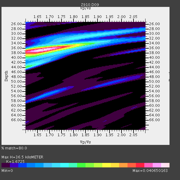
| Thickness Estimate: | 36 km |
| Thickness StdDev: | 0.7 km |
| Vp/Vs Estimate: | 1.67 |
| Vp/Vs StdDev: | 0.04 |
| Vs Estimate: | 3.797 km/s |
| Poisson's Ratio: | 0.22 |
| Peak Value: | 0.04 |
| Assumed Vp: | 6.35 km/s |
| Ps Weight: | 0.33333334 |
| PpPs Weight: | 0.33333334 |
| PsPs Weight: | 0.33333328 |
| Residual Complexity: | 0.539 |
| Nearby stations H: | +- |
| (2.0 deg) Vp/Vs: | +- |
6 with match > 90% ( 14.285714 %) and 6 with match > 80% ( 14.285714 %) out of 42.
Download stack as xyz text file.
Azimuth Distribution of Events:
Prior Results for this Station
| Study | Thickness | Vp/Vs | Vp | Vs | Poissons Ratio | Extra |
| EARS | 36 km | 1.67 | 6.35 km/s | 3.797 km/s | 0.22 | |
| Crust2.0 | 43 km | 1.76 | 6.35 km/s | 3.609 km/s | 0.26 | P6,orogen/43km, Orogen, 0.5 km seds. |
| Global Maxima | 36 km | 1.67 | 6.35 km/s | 3.797 km/s | 0.22 | amp=0.040650163 |
| Local Maxima 1 | 44 km | 1.60 | 6.35 km/s | 3.969 km/s | 0.18 | amp=0.02009593 |
| Local Maxima 2 | 37 km | 1.60 | 6.35 km/s | 3.969 km/s | 0.18 | amp=0.019731853 |
| Local Maxima 3 | 36 km | 1.76 | 6.35 km/s | 3.603 km/s | 0.26 | amp=0.015577127 |
| Local Maxima 4 | 30 km | 1.88 | 6.35 km/s | 3.378 km/s | 0.30 | amp=0.0112755075 |
| Predicted Arrivals for vertical incidence (zero ray parameter) | |
| Ps | 3.87 SECOND |
| PpPs | 15.36 SECOND |
| PsPs/PpSs | 19.23 SECOND |
Events Processed for this Station
Download zip of receiver functions as SAC
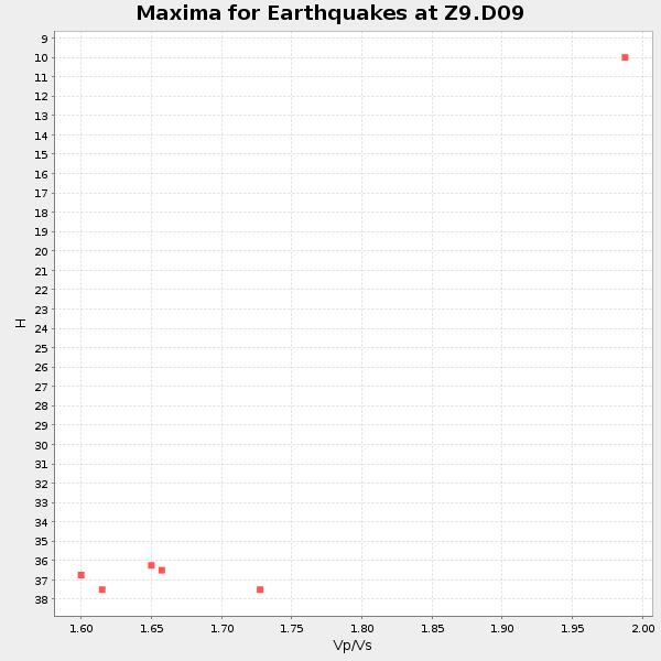
Plot maxima for each earthquake.
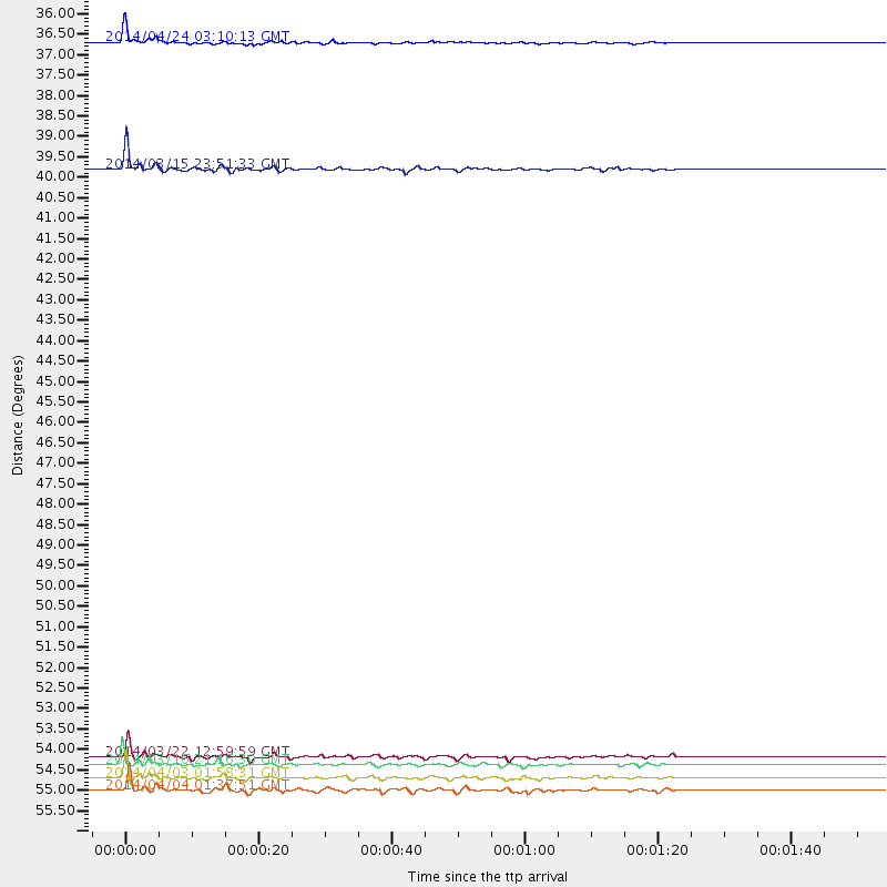
Events Used in the Stack
(6 events)| Radial Match | Distance | Baz | FERegion | Time | Lat/Lon | Depth | Magnitude |
| 95.84922 | 36.1 deg | 309.6 deg | Vancouver Island, Canada Region | 2014/04/24 03:10:13 GMT | (49.8, -127.4) | 11 km | 6.7 MWP, 6.7 MI |
| 94.786606 | 54.9 deg | 165.937 deg | Near Coast Of Northern Chile | 2014/03/16 21:16:30 GMT | (-19.9, -70.6) | 20 km | 6.7 MWW, 6.7 MWC, 7.0 MI |
| 93.20329 | 55.3 deg | 165.946 deg | Near Coast Of Northern Chile | 2014/04/03 01:58:31 GMT | (-20.3, -70.6) | 23 km | 6.5 MWW, 6.5 MWB, 6.6 MWC |
| 92.163284 | 39.4 deg | 177.068 deg | Near Coast Of Northern Peru | 2014/03/15 23:51:33 GMT | (-5.6, -81.0) | 29 km | 6.3 MWW, 6.2 MWB, 6.3 MWC |
| 90.64821 | 55.6 deg | 166.241 deg | Near Coast Of Northern Chile | 2014/04/04 01:37:51 GMT | (-20.6, -70.7) | 20 km | 6.1 MWP, 6.1 MWB, 6.1 MWW, 6.3 MWC |
| 90.546165 | 54.7 deg | 166.172 deg | Near Coast Of Northern Chile | 2014/03/22 12:59:59 GMT | (-19.8, -70.9) | 20 km | 6.2 MWW, 6.2 MWB, 6.3 MWC, 6.4 MWC |
Losers
(36 events)| Radial Match | Distance | Baz | FERegion | Time | Lat/Lon | Depth | Magnitude | Reason |
| 98.55415 | 54.6 deg | 166.077 deg | Near Coast Of Northern Chile | 2014/04/01 23:46:46 GMT | (-19.6, -70.8) | 20 km | 8.2 MWW, 8.0 MI, 8.1 MWC | |
| 96.529785 | 55.6 deg | 166.238 deg | Near Coast Of Northern Chile | 2014/04/03 03:11:14 GMT | (-20.6, -70.7) | 10 km | 5.8 MB | |
| 96.34938 | 55.5 deg | 165.947 deg | Near Coast Of Northern Chile | 2014/04/03 02:43:14 GMT | (-20.5, -70.5) | 31 km | 7.7 MWW, 7.4 MI, 7.7 MWC | |
| 93.474976 | 34.0 deg | 294.06 deg | Off Coast Of Northern California | 2014/03/10 05:18:13 GMT | (40.8, -125.1) | 17 km | 6.8 MW, 6.8 MWR, 6.9 MWW, 6.9 MWB, 7.0 MI, 7.0 MWC | |
| 92.604454 | 54.6 deg | 166.064 deg | Near Coast Of Northern Chile | 2014/04/02 00:06:44 GMT | (-19.6, -70.8) | 10 km | 5.7 MB | |
| 87.29929 | 94.7 deg | 334.886 deg | E. Russia-N.E. China Border Reg. | 2014/04/12 21:22:44 GMT | (44.9, 133.7) | 10 km | 4.3 mb | |
| 78.73531 | 54.7 deg | 166.096 deg | Near Coast Of Northern Chile | 2014/03/23 18:20:03 GMT | (-19.7, -70.8) | 35 km | 6.0 MB, 6.2 MWB, 6.2 MWW, 6.3 MWC | |
| 77.31225 | 78.8 deg | 51.371 deg | Greece | 2014/02/03 03:08:46 GMT | (38.3, 20.4) | 5.0 km | 6.0 MWW, 6.0 MWB, 6.1 MWC | |
| 76.38417 | 48.3 deg | 171.512 deg | Near Coast Of Peru | 2014/03/15 08:59:21 GMT | (-14.1, -76.3) | 20 km | 6.1 MWW, 6.0 MWB, 6.2 MWC | |
| 74.21094 | 54.6 deg | 165.302 deg | Near Coast Of Northern Chile | 2014/04/01 23:59:57 GMT | (-19.5, -70.2) | 22 km | 5.8 MB | |
| 73.40472 | 76.4 deg | 52.271 deg | Southern Italy | 2014/04/05 10:24:45 GMT | (38.9, 17.2) | 56 km | 4.8 MW | |
| 72.168495 | 48.4 deg | 170.614 deg | Near Coast Of Peru | 2014/02/18 23:35:58 GMT | (-14.2, -75.6) | 57 km | 6.0 MWB, 5.9 MWW, 5.9 MWC, 6.0 MWC | |
| 70.17653 | 55.1 deg | 166.247 deg | Near Coast Of Northern Chile | 2014/04/02 04:46:18 GMT | (-20.2, -70.9) | 10 km | 5.8 MB | |
| 66.51811 | 55.1 deg | 332.723 deg | Northern Alaska | 2014/04/18 18:44:17 GMT | (67.7, -162.5) | 1.0 km | 5.5 MB, 5.4 MI | |
| 65.87388 | 79.7 deg | 175.601 deg | Off Coast Of Southern Chile | 2014/03/02 11:14:42 GMT | (-45.8, -76.6) | 23 km | 5.2 MW | |
| 65.79339 | 88.3 deg | 199.928 deg | Southern East Pacific Rise | 2014/05/12 18:38:37 GMT | (-50.0, -114.7) | 8.2 km | 5.8 MB | |
| 63.871876 | 55.5 deg | 166.236 deg | Near Coast Of Northern Chile | 2014/04/13 12:11:30 GMT | (-20.6, -70.7) | 13 km | 5.5 MWW, 5.3 MWR | |
| 63.370598 | 54.6 deg | 165.705 deg | Near Coast Of Northern Chile | 2014/04/02 00:04:54 GMT | (-19.6, -70.5) | 34 km | 5.5 MB | |
| 62.34687 | 83.9 deg | 326.236 deg | Kuril Islands | 2014/04/03 10:26:01 GMT | (48.4, 153.2) | 159 km | 4.2 mb | |
| 62.300095 | 55.1 deg | 332.769 deg | Northern Alaska | 2014/04/18 18:56:47 GMT | (67.7, -162.5) | 17 km | 5.7 MW | |
| 58.77612 | 71.2 deg | 191.799 deg | West Chile Rise | 2014/05/06 20:52:29 GMT | (-36.3, -96.7) | 14 km | 5.9 MWB | |
| 56.078518 | 68.0 deg | 317.561 deg | Andreanof Islands, Aleutian Is. | 2014/01/16 07:33:09 GMT | (51.2, -179.2) | 27 km | 5.5 MWB, 5.2 ML, 5.5 ML, 5.6 MWC | |
| 55.964436 | 55.1 deg | 166.265 deg | Near Coast Of Northern Chile | 2014/04/07 13:43:20 GMT | (-20.2, -70.9) | 7.9 km | 5.8 MWB, 5.7 MWW, 5.7 MWC | |
| 55.277206 | 62.9 deg | 317.966 deg | Fox Islands, Aleutian Islands | 2014/02/26 21:13:40 GMT | (53.6, -171.8) | 265 km | 6.1 MWW, 5.9 MI, 5.9 ML, 6.1 MWC, 6.1 MWB, 6.2 MWC | |
| 54.342007 | 56.0 deg | 158.325 deg | Southern Bolivia | 2014/01/27 16:42:37 GMT | (-19.3, -63.9) | 600 km | 5.6 MWB | |
| 52.700485 | 54.6 deg | 166.067 deg | Near Coast Of Northern Chile | 2014/03/24 15:45:31 GMT | (-19.6, -70.8) | 18 km | 5.6 MWB, 5.5 MWR, 5.7 MWC, 5.7 MWW | |
| 52.521008 | 51.0 deg | 322.792 deg | Southern Alaska | 2014/05/10 14:16:08 GMT | (60.0, -152.2) | 96 km | 5.8 ML, 5.5 MI, 5.7 MWP | |
| 49.387764 | 81.6 deg | 50.643 deg | Southern Greece | 2014/04/04 20:08:07 GMT | (37.2, 23.8) | 107 km | 5.5 MWB, 5.5 MWR, 5.6 MWC, 5.6 MWW | |
| 49.116455 | 54.8 deg | 166.149 deg | Near Coast Of Northern Chile | 2014/03/23 20:23:04 GMT | (-19.9, -70.8) | 23 km | 5.3 MW | |
| 46.55765 | 79.7 deg | 175.276 deg | Off Coast Of Southern Chile | 2014/03/02 17:03:43 GMT | (-45.8, -76.2) | 10 km | 5.4 MW | |
| 45.41075 | 54.9 deg | 166.042 deg | Near Coast Of Northern Chile | 2014/03/17 08:32:37 GMT | (-20.0, -70.7) | 15 km | 5.1 MW | |
| 43.715393 | 83.8 deg | 326.214 deg | Kuril Islands | 2014/04/26 13:55:55 GMT | (48.5, 153.3) | 131 km | 5.1 MW | |
| 41.412178 | 36.2 deg | 299.142 deg | Off Coast Of Oregon | 2014/05/12 18:51:00 GMT | (43.7, -128.1) | 14 km | 5.5 MW | |
| 38.702106 | 55.0 deg | 332.664 deg | Northern Alaska | 2014/05/03 08:57:12 GMT | (67.6, -162.2) | 0.9 km | 5.5 MB | |
| 37.406063 | 54.8 deg | 166.161 deg | Near Coast Of Northern Chile | 2014/05/05 22:52:23 GMT | (-19.9, -70.8) | 12 km | 4.9 Mww | |
| 33.61245 | 55.4 deg | 166.002 deg | Near Coast Of Northern Chile | 2014/04/02 19:45:49 GMT | (-20.4, -70.6) | 17 km | 5.3 MW |

