
Station Z9 D11 - Parham Farm, Dewey Rose, GA
Network: Z910 - Southeastern Suture of the Appalachian Margin Experiment
Nearby stations (2 deg radius)
| Station | Name | (Lat, Lon) | Start / End | Elevation |
| D11 | Parham Farm, Dewey Rose, GA | (34.16, -82.97) | 2011-05-18 / 2014-05-12 | 216 m |
| Crust2 Type: | P6,orogen/43km, Orogen, 0.5 km seds. |
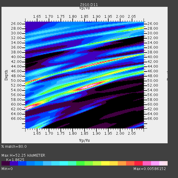
| Thickness Estimate: | 52 km |
| Thickness StdDev: | 6.6 km |
| Vp/Vs Estimate: | 1.86 |
| Vp/Vs StdDev: | 0.17 |
| Vs Estimate: | 3.409 km/s |
| Poisson's Ratio: | 0.30 |
| Peak Value: | 0.01 |
| Assumed Vp: | 6.35 km/s |
| Ps Weight: | 0.33333334 |
| PpPs Weight: | 0.33333334 |
| PsPs Weight: | 0.33333328 |
| Residual Complexity: | 0.865 |
| Nearby stations H: | +- |
| (2.0 deg) Vp/Vs: | +- |
3 with match > 90% ( 37.5 %) and 3 with match > 80% ( 37.5 %) out of 8.
Download stack as xyz text file.
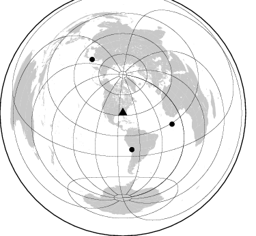
Azimuth Distribution of Events:
Prior Results for this Station
| Study | Thickness | Vp/Vs | Vp | Vs | Poissons Ratio | Extra |
| EARS | 52 km | 1.86 | 6.35 km/s | 3.409 km/s | 0.30 | |
| Crust2.0 | 43 km | 1.76 | 6.35 km/s | 3.609 km/s | 0.26 | P6,orogen/43km, Orogen, 0.5 km seds. |
| Global Maxima | 52 km | 1.86 | 6.35 km/s | 3.409 km/s | 0.30 | amp=0.00586152 |
| Local Maxima 1 | 61 km | 1.61 | 6.35 km/s | 3.938 km/s | 0.19 | amp=0.0056120125 |
| Local Maxima 2 | 43 km | 1.88 | 6.35 km/s | 3.387 km/s | 0.30 | amp=0.005368073 |
| Local Maxima 3 | 50 km | 1.62 | 6.35 km/s | 3.92 km/s | 0.19 | amp=0.004926785 |
| Local Maxima 4 | 33 km | 1.95 | 6.35 km/s | 3.252 km/s | 0.32 | amp=0.0035945524 |
| Predicted Arrivals for vertical incidence (zero ray parameter) | |
| Ps | 7.10 SECOND |
| PpPs | 23.55 SECOND |
| PsPs/PpSs | 30.65 SECOND |
Events Processed for this Station
Download zip of receiver functions as SAC
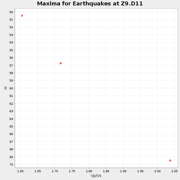
Plot maxima for each earthquake.
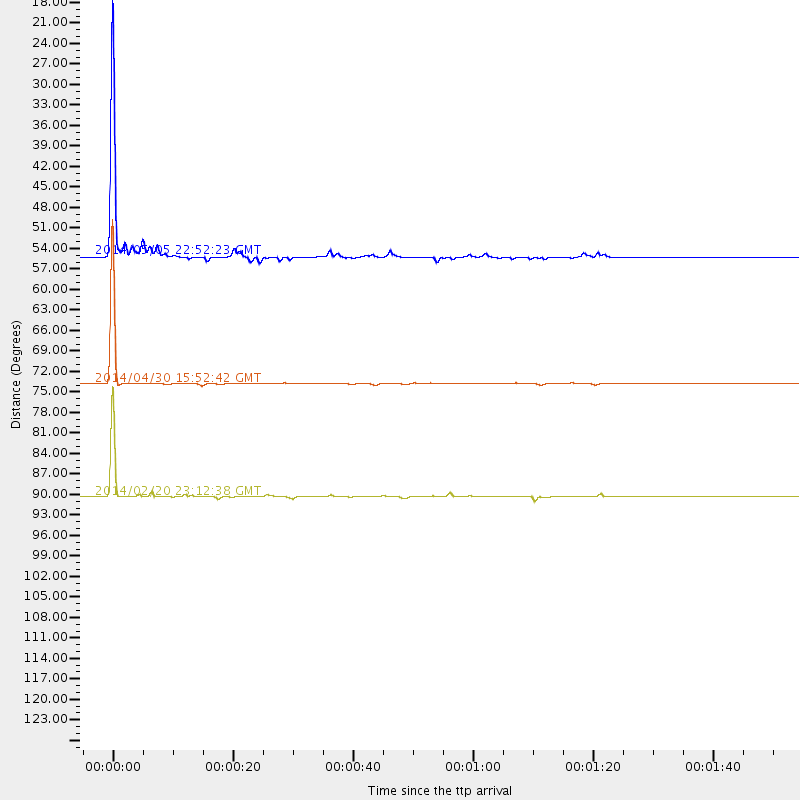
Events Used in the Stack
(3 events)| Radial Match | Distance | Baz | FERegion | Time | Lat/Lon | Depth | Magnitude |
| 99.80833 | 73.8 deg | 102.861 deg | North Of Ascension Island | 2014/04/30 15:52:42 GMT | (-1.2, -13.5) | 14 km | 5.8 MW |
| 98.9034 | 90.3 deg | 330.043 deg | Hokkaido, Japan Region | 2014/02/20 23:12:38 GMT | (45.9, 142.6) | 324 km | 5.2 MW |
| 98.240616 | 55.0 deg | 166.016 deg | Near Coast Of Northern Chile | 2014/05/05 22:52:23 GMT | (-19.9, -70.8) | 12 km | 4.9 Mww |
Losers
(5 events)| Radial Match | Distance | Baz | FERegion | Time | Lat/Lon | Depth | Magnitude | Reason |
| 99.992966 | 54.9 deg | 332.622 deg | Northern Alaska | 2014/05/03 08:57:12 GMT | (67.6, -162.2) | 0.9 km | 5.5 MB | |
| 99.13489 | 68.2 deg | 170.109 deg | Near Coast Of Central Chile | 2014/03/04 10:51:15 GMT | (-33.6, -72.0) | 20 km | 5.7 MWW, 5.7 MWB, 5.8 MWC | |
| 93.21115 | 57.8 deg | 164.475 deg | Northern Chile | 2014/02/12 11:43:10 GMT | (-22.4, -68.8) | 100 km | 5.6 MWW, 5.6 MWR | |
| 88.51658 | 69.6 deg | 170.381 deg | Central Chile | 2014/03/04 11:24:20 GMT | (-35.0, -72.0) | 48 km | 4.9 mb | |
| 73.532265 | 64.2 deg | 212.207 deg | Easter Island Region | 2014/02/14 07:44:15 GMT | (-23.0, -114.3) | 12 km | 5.6 MWW, 5.5 MWB, 5.6 MWC |

