
Station Z9 D13 - Victoria Bryant State Park, Royston, GA
Network: Z910 - Southeastern Suture of the Appalachian Margin Experiment
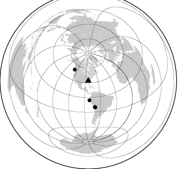
Nearby stations (2 deg radius)
| Station | Name | (Lat, Lon) | Start / End | Elevation |
| D13 | Victoria Bryant State Park, Royston, GA | (34.29, -83.17) | 2011-10-22 / 2014-05-19 | 200 m |
| Crust2 Type: | P6,orogen/43km, Orogen, 0.5 km seds. |
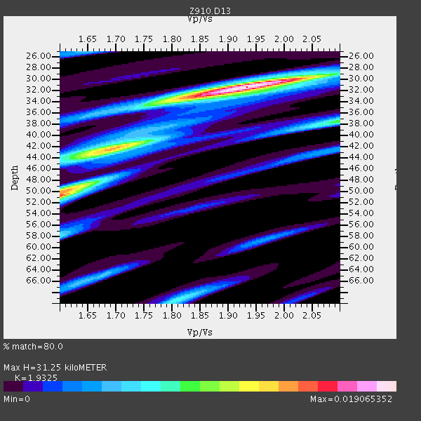
| Thickness Estimate: | 31 km |
| Thickness StdDev: | 8.0 km |
| Vp/Vs Estimate: | 1.93 |
| Vp/Vs StdDev: | 0.16 |
| Vs Estimate: | 3.286 km/s |
| Poisson's Ratio: | 0.32 |
| Peak Value: | 0.02 |
| Assumed Vp: | 6.35 km/s |
| Ps Weight: | 0.33333334 |
| PpPs Weight: | 0.33333334 |
| PsPs Weight: | 0.33333328 |
| Residual Complexity: | 0.629 |
| Nearby stations H: | +- |
| (2.0 deg) Vp/Vs: | +- |
5 with match > 90% ( 14.705882 %) and 7 with match > 80% ( 20.588236 %) out of 34.
Download stack as xyz text file.
Azimuth Distribution of Events:
Prior Results for this Station
| Study | Thickness | Vp/Vs | Vp | Vs | Poissons Ratio | Extra |
| EARS | 31 km | 1.93 | 6.35 km/s | 3.286 km/s | 0.32 | |
| Crust2.0 | 43 km | 1.76 | 6.35 km/s | 3.609 km/s | 0.26 | P6,orogen/43km, Orogen, 0.5 km seds. |
| Global Maxima | 31 km | 1.93 | 6.35 km/s | 3.286 km/s | 0.32 | amp=0.019065352 |
| Local Maxima 1 | 50 km | 1.60 | 6.35 km/s | 3.963 km/s | 0.18 | amp=0.014315459 |
| Local Maxima 2 | 42 km | 1.70 | 6.35 km/s | 3.746 km/s | 0.23 | amp=0.012583799 |
| Local Maxima 3 | 38 km | 2.10 | 6.35 km/s | 3.031 km/s | 0.35 | amp=0.0076752985 |
| Local Maxima 4 | 69 km | 1.81 | 6.35 km/s | 3.503 km/s | 0.28 | amp=0.007080727 |
| Predicted Arrivals for vertical incidence (zero ray parameter) | |
| Ps | 4.59 SECOND |
| PpPs | 14.43 SECOND |
| PsPs/PpSs | 19.02 SECOND |
Events Processed for this Station
Download zip of receiver functions as SAC
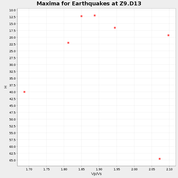
Plot maxima for each earthquake.
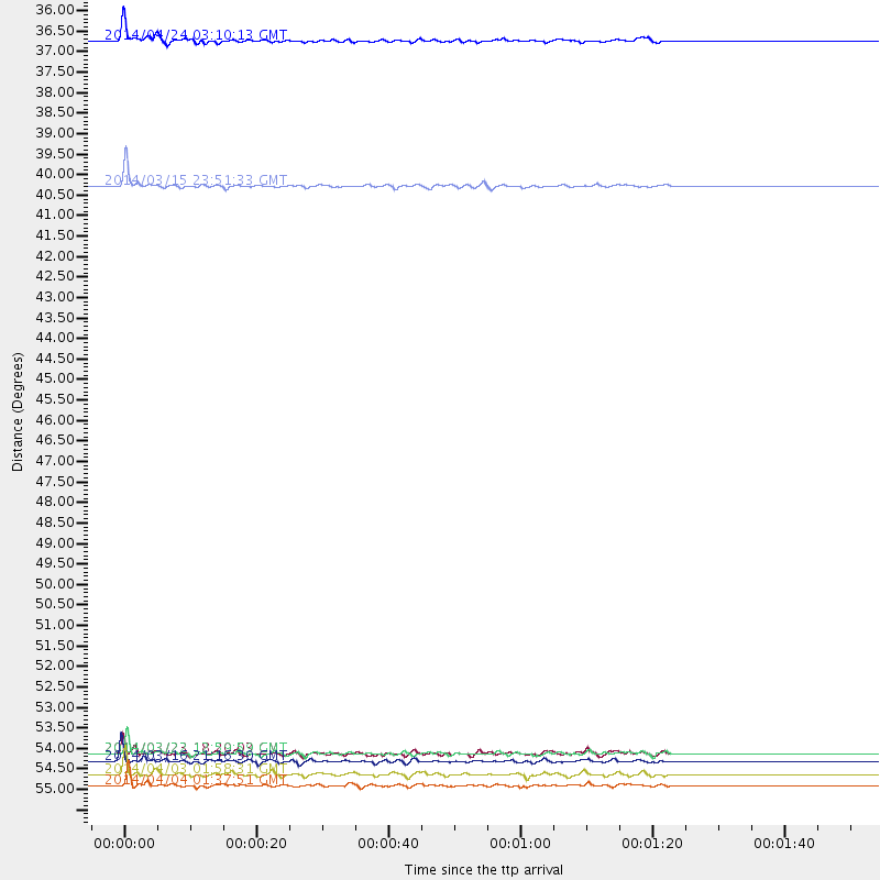
Events Used in the Stack
(7 events)| Radial Match | Distance | Baz | FERegion | Time | Lat/Lon | Depth | Magnitude |
| 94.39965 | 55.6 deg | 165.612 deg | Near Coast Of Northern Chile | 2014/04/03 01:58:31 GMT | (-20.3, -70.6) | 23 km | 6.5 MWW, 6.5 MWB, 6.6 MWC |
| 94.196266 | 55.2 deg | 165.601 deg | Near Coast Of Northern Chile | 2014/03/16 21:16:30 GMT | (-19.9, -70.6) | 20 km | 6.7 MWW, 6.7 MWC, 7.0 MI |
| 92.98331 | 35.8 deg | 309.392 deg | Vancouver Island, Canada Region | 2014/04/24 03:10:13 GMT | (49.8, -127.4) | 11 km | 6.7 MWP, 6.7 MI |
| 91.49972 | 55.0 deg | 165.834 deg | Near Coast Of Northern Chile | 2014/03/22 12:59:59 GMT | (-19.8, -70.9) | 20 km | 6.2 MWW, 6.2 MWB, 6.3 MWC, 6.4 MWC |
| 90.42777 | 39.7 deg | 176.557 deg | Near Coast Of Northern Peru | 2014/03/15 23:51:33 GMT | (-5.6, -81.0) | 29 km | 6.3 MWW, 6.2 MWB, 6.3 MWC |
| 88.978165 | 55.9 deg | 165.907 deg | Near Coast Of Northern Chile | 2014/04/04 01:37:51 GMT | (-20.6, -70.7) | 20 km | 6.1 MWP, 6.1 MWB, 6.1 MWW, 6.3 MWC |
| 83.988174 | 55.0 deg | 165.758 deg | Near Coast Of Northern Chile | 2014/03/23 18:20:03 GMT | (-19.7, -70.8) | 35 km | 6.0 MB, 6.2 MWB, 6.2 MWW, 6.3 MWC |
Losers
(27 events)| Radial Match | Distance | Baz | FERegion | Time | Lat/Lon | Depth | Magnitude | Reason |
| 99.06494 | 55.9 deg | 165.904 deg | Near Coast Of Northern Chile | 2014/04/03 03:11:14 GMT | (-20.6, -70.7) | 10 km | 5.8 MB | |
| 98.93819 | 54.9 deg | 165.738 deg | Near Coast Of Northern Chile | 2014/04/01 23:46:46 GMT | (-19.6, -70.8) | 20 km | 8.2 MWW, 8.0 MI, 8.1 MWC | |
| 96.24173 | 33.7 deg | 293.701 deg | Off Coast Of Northern California | 2014/03/10 05:18:13 GMT | (40.8, -125.1) | 17 km | 6.8 MW, 6.8 MWR, 6.9 MWW, 6.9 MWB, 7.0 MI, 7.0 MWC | |
| 96.165184 | 55.8 deg | 165.613 deg | Near Coast Of Northern Chile | 2014/04/03 02:43:14 GMT | (-20.5, -70.5) | 31 km | 7.7 MWW, 7.4 MI, 7.7 MWC | |
| 93.24558 | 94.4 deg | 334.685 deg | E. Russia-N.E. China Border Reg. | 2014/04/12 21:22:44 GMT | (44.9, 133.7) | 10 km | 4.3 mb | |
| 90.24001 | 54.9 deg | 165.725 deg | Near Coast Of Northern Chile | 2014/04/02 00:06:44 GMT | (-19.6, -70.8) | 10 km | 5.7 MB | |
| 90.23545 | 50.7 deg | 322.662 deg | Southern Alaska | 2014/05/10 14:16:08 GMT | (60.0, -152.2) | 96 km | 5.8 ML, 5.5 MI, 5.7 MWP | |
| 70.76055 | 78.9 deg | 51.255 deg | Greece | 2014/02/03 03:08:46 GMT | (38.3, 20.4) | 5.0 km | 6.0 MWW, 6.0 MWB, 6.1 MWC | |
| 69.704605 | 98.2 deg | 324.761 deg | Near East Coast Of Honshu, Japan | 2014/03/29 01:53:57 GMT | (36.3, 141.8) | 20 km | 5.5 MWC, 5.4 MWB, 5.5 MWC | |
| 67.12021 | 48.7 deg | 170.217 deg | Near Coast Of Peru | 2014/02/18 23:35:58 GMT | (-14.2, -75.6) | 57 km | 6.0 MWB, 5.9 MWW, 5.9 MWC, 6.0 MWC | |
| 66.80255 | 88.4 deg | 199.729 deg | Southern East Pacific Rise | 2014/05/12 18:38:37 GMT | (-50.0, -114.7) | 8.2 km | 5.8 MB | |
| 61.937893 | 55.4 deg | 165.91 deg | Near Coast Of Northern Chile | 2014/04/02 04:46:18 GMT | (-20.2, -70.9) | 10 km | 5.8 MB | |
| 61.152164 | 54.7 deg | 332.57 deg | Northern Alaska | 2014/05/03 08:57:12 GMT | (67.6, -162.2) | 0.9 km | 5.5 MB | |
| 60.977333 | 54.9 deg | 164.967 deg | Near Coast Of Northern Chile | 2014/04/01 23:59:57 GMT | (-19.5, -70.2) | 22 km | 5.8 MB | |
| 59.67705 | 55.1 deg | 165.84 deg | Near Coast Of Northern Chile | 2014/03/22 13:14:55 GMT | (-19.8, -70.9) | 4.6 km | 5.2 Mww | |
| 57.0537 | 48.6 deg | 171.11 deg | Near Coast Of Peru | 2014/03/15 08:59:21 GMT | (-14.1, -76.3) | 20 km | 6.1 MWW, 6.0 MWB, 6.2 MWC | |
| 55.173233 | 35.8 deg | 298.84 deg | Off Coast Of Oregon | 2014/05/12 18:51:00 GMT | (43.7, -128.1) | 14 km | 5.5 MW | |
| 53.985554 | 55.7 deg | 166.087 deg | Near Coast Of Northern Chile | 2014/04/08 10:14:32 GMT | (-20.5, -70.9) | 7.1 km | 5.7 MWB, 5.5 MWR, 5.6 MWC, 5.6 MWW | |
| 52.856686 | 62.5 deg | 317.798 deg | Fox Islands, Aleutian Islands | 2014/02/26 21:13:40 GMT | (53.6, -171.8) | 265 km | 6.1 MWW, 5.9 MI, 5.9 ML, 6.1 MWC, 6.1 MWB, 6.2 MWC | |
| 52.63254 | 55.0 deg | 165.966 deg | Near Coast Of Northern Chile | 2014/03/22 22:14:57 GMT | (-19.7, -71.0) | 19 km | 5.1 MW | |
| 50.44746 | 67.6 deg | 317.387 deg | Andreanof Islands, Aleutian Is. | 2014/01/16 07:33:09 GMT | (51.2, -179.2) | 27 km | 5.5 MWB, 5.2 ML, 5.5 ML, 5.6 MWC | |
| 47.501205 | 71.4 deg | 191.5 deg | West Chile Rise | 2014/05/06 20:52:29 GMT | (-36.3, -96.7) | 14 km | 5.9 MWB | |
| 45.077095 | 55.4 deg | 165.929 deg | Near Coast Of Northern Chile | 2014/04/07 13:43:20 GMT | (-20.2, -70.9) | 7.9 km | 5.8 MWB, 5.7 MWW, 5.7 MWC | |
| 41.814102 | 96.0 deg | 325.849 deg | Near East Coast Of Honshu, Japan | 2014/02/05 17:32:13 GMT | (38.7, 142.4) | 46 km | 5.3 MW | |
| 40.994522 | 95.8 deg | 324.158 deg | Off East Coast Of Honshu, Japan | 2014/05/02 09:15:20 GMT | (37.9, 144.2) | 15 km | 5.9 MWP | |
| 38.066536 | 54.9 deg | 165.368 deg | Near Coast Of Northern Chile | 2014/04/02 00:04:54 GMT | (-19.6, -70.5) | 34 km | 5.5 MB | |
| 37.819065 | 81.6 deg | 50.508 deg | Southern Greece | 2014/04/04 20:08:07 GMT | (37.2, 23.8) | 107 km | 5.5 MWB, 5.5 MWR, 5.6 MWC, 5.6 MWW |

