
Station Z9 D14 - Burroughs Farm, Carnesville, GA
Network: Z910 - Southeastern Suture of the Appalachian Margin Experiment
Nearby stations (2 deg radius)
| Station | Name | (Lat, Lon) | Start / End | Elevation |
| D14 | Burroughs Farm, Carnesville, GA | (34.38, -83.18) | 2011-05-16 / 2014-05-19 | 211 m |
| Crust2 Type: | P6,orogen/43km, Orogen, 0.5 km seds. |
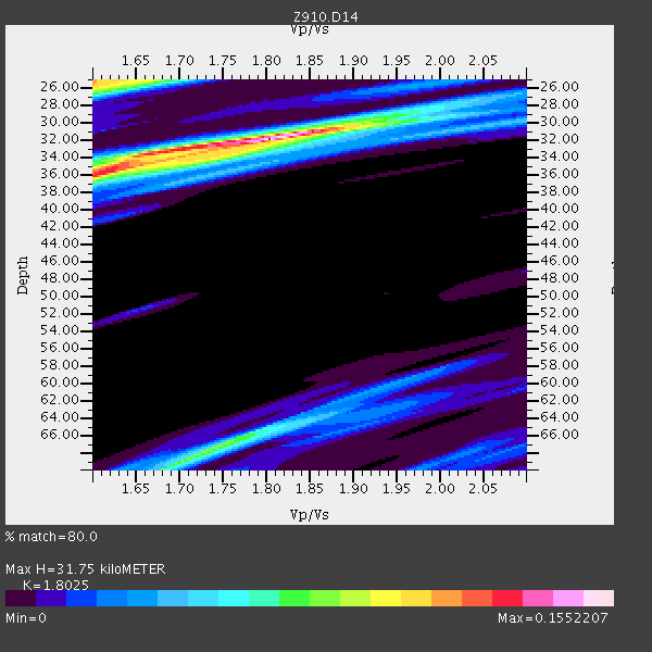
| Thickness Estimate: | 32 km |
| Thickness StdDev: | 7.9 km |
| Vp/Vs Estimate: | 1.80 |
| Vp/Vs StdDev: | 0.10 |
| Vs Estimate: | 3.523 km/s |
| Poisson's Ratio: | 0.28 |
| Peak Value: | 0.16 |
| Assumed Vp: | 6.35 km/s |
| Ps Weight: | 0.33333334 |
| PpPs Weight: | 0.33333334 |
| PsPs Weight: | 0.33333328 |
| Residual Complexity: | 0.603 |
| Nearby stations H: | +- |
| (2.0 deg) Vp/Vs: | +- |
4 with match > 90% ( 8.510638 %) and 7 with match > 80% ( 14.893617 %) out of 47.
Download stack as xyz text file.
Azimuth Distribution of Events:

Prior Results for this Station
| Study | Thickness | Vp/Vs | Vp | Vs | Poissons Ratio | Extra |
| EARS | 32 km | 1.80 | 6.35 km/s | 3.523 km/s | 0.28 | |
| Crust2.0 | 43 km | 1.76 | 6.35 km/s | 3.609 km/s | 0.26 | P6,orogen/43km, Orogen, 0.5 km seds. |
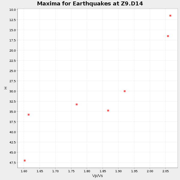
| Global Maxima | 32 km | 1.80 | 6.35 km/s | 3.523 km/s | 0.28 | amp=0.1552207 |
| Local Maxima 1 | 36 km | 1.61 | 6.35 km/s | 3.944 km/s | 0.19 | amp=0.113367505 |
| Local Maxima 2 | 25 km | 1.60 | 6.35 km/s | 3.969 km/s | 0.18 | amp=0.1103265 |
| Local Maxima 3 | 68 km | 1.73 | 6.35 km/s | 3.671 km/s | 0.25 | amp=0.08463276 |
| Local Maxima 4 | 34 km | 1.66 | 6.35 km/s | 3.825 km/s | 0.22 | amp=0.054216232 |
| Predicted Arrivals for vertical incidence (zero ray parameter) | |
| Ps | 4.01 SECOND |
| PpPs | 14.01 SECOND |
| PsPs/PpSs | 18.03 SECOND |
Events Processed for this Station
Download zip of receiver functions as SAC
Plot maxima for each earthquake.
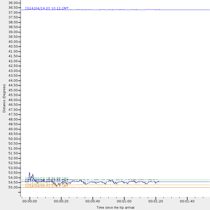
Events Used in the Stack
(7 events)| Radial Match | Distance | Baz | FERegion | Time | Lat/Lon | Depth | Magnitude |
| 94.16091 | 35.7 deg | 309.306 deg | Vancouver Island, Canada Region | 2014/04/24 03:10:13 GMT | (49.8, -127.4) | 11 km | 6.7 MWP, 6.7 MI |
| 93.63079 | 55.7 deg | 165.609 deg | Near Coast Of Northern Chile | 2014/04/03 01:58:31 GMT | (-20.3, -70.6) | 23 km | 6.5 MWW, 6.5 MWB, 6.6 MWC |
| 93.62315 | 55.3 deg | 165.598 deg | Near Coast Of Northern Chile | 2014/03/16 21:16:30 GMT | (-19.9, -70.6) | 20 km | 6.7 MWW, 6.7 MWC, 7.0 MI |
| 91.65752 | 55.1 deg | 165.831 deg | Near Coast Of Northern Chile | 2014/03/22 12:59:59 GMT | (-19.8, -70.9) | 20 km | 6.2 MWW, 6.2 MWB, 6.3 MWC, 6.4 MWC |
| 88.15222 | 56.0 deg | 165.904 deg | Near Coast Of Northern Chile | 2014/04/04 01:37:51 GMT | (-20.6, -70.7) | 20 km | 6.1 MWP, 6.1 MWB, 6.1 MWW, 6.3 MWC |
| 84.869774 | 55.1 deg | 165.755 deg | Near Coast Of Northern Chile | 2014/03/23 18:20:03 GMT | (-19.7, -70.8) | 35 km | 6.0 MB, 6.2 MWB, 6.2 MWW, 6.3 MWC |
| 84.21919 | 55.3 deg | 165.963 deg | Near Coast Of Northern Chile | 2014/03/18 21:33:05 GMT | (-20.0, -70.9) | 6.3 km | 5.1 mb |
Losers
(40 events)| Radial Match | Distance | Baz | FERegion | Time | Lat/Lon | Depth | Magnitude | Reason |
| 98.921005 | 55.0 deg | 165.736 deg | Near Coast Of Northern Chile | 2014/04/01 23:46:46 GMT | (-19.6, -70.8) | 20 km | 8.2 MWW, 8.0 MI, 8.1 MWC | |
| 98.86181 | 56.0 deg | 165.901 deg | Near Coast Of Northern Chile | 2014/04/03 03:11:14 GMT | (-20.6, -70.7) | 10 km | 5.8 MB | |
| 96.15819 | 33.6 deg | 293.587 deg | Off Coast Of Northern California | 2014/03/10 05:18:13 GMT | (40.8, -125.1) | 17 km | 6.8 MW, 6.8 MWR, 6.9 MWW, 6.9 MWB, 7.0 MI, 7.0 MWC | |
| 95.430756 | 55.9 deg | 165.611 deg | Near Coast Of Northern Chile | 2014/04/03 02:43:14 GMT | (-20.5, -70.5) | 31 km | 7.7 MWW, 7.4 MI, 7.7 MWC | |
| 94.91718 | 55.0 deg | 165.723 deg | Near Coast Of Northern Chile | 2014/04/02 00:06:44 GMT | (-19.6, -70.8) | 10 km | 5.7 MB | |
| 94.81811 | 94.3 deg | 334.679 deg | E. Russia-N.E. China Border Reg. | 2014/04/12 21:22:44 GMT | (44.9, 133.7) | 10 km | 4.3 mb | |
| 87.76378 | 50.6 deg | 322.621 deg | Southern Alaska | 2014/05/10 14:16:08 GMT | (60.0, -152.2) | 96 km | 5.8 ML, 5.5 MI, 5.7 MWP | |
| 84.23471 | 56.2 deg | 165.742 deg | Near Coast Of Northern Chile | 2014/04/03 05:26:16 GMT | (-20.8, -70.5) | 24 km | 6.2 MWP, 6.2 MWR, 6.3 MWW, 6.5 MWC | |
| 80.45765 | 55.6 deg | 165.75 deg | Near Coast Of Northern Chile | 2014/04/02 00:33:45 GMT | (-20.2, -70.7) | 13 km | 5.5 MB | |
| 78.0639 | 55.3 deg | 165.894 deg | Near Coast Of Northern Chile | 2014/03/17 05:11:34 GMT | (-20.0, -70.9) | 17 km | 6.2 MWW, 6.2 MWB, 6.5 MWC | |
| 77.65784 | 64.6 deg | 165.996 deg | San Juan Province, Argentina | 2014/03/27 23:50:52 GMT | (-29.1, -68.7) | 9.9 km | 5.5 MWP, 5.6 MWB, 5.7 MWW, 5.7 MWC | |
| 73.75607 | 54.9 deg | 165.851 deg | Near Coast Of Northern Chile | 2014/04/02 01:20:59 GMT | (-19.6, -70.9) | 22 km | 5.2 mb | |
| 73.081505 | 48.6 deg | 171.102 deg | Near Coast Of Peru | 2014/03/15 08:59:21 GMT | (-14.1, -76.3) | 20 km | 6.1 MWW, 6.0 MWB, 6.2 MWC | |
| 68.29905 | 56.1 deg | 165.857 deg | Near Coast Of Northern Chile | 2014/04/14 05:56:20 GMT | (-20.7, -70.7) | 30 km | 5.3 MW | |
| 64.369064 | 55.2 deg | 165.809 deg | Near Coast Of Northern Chile | 2014/03/23 20:23:04 GMT | (-19.9, -70.8) | 23 km | 5.3 MW | |
| 63.5142 | 48.8 deg | 170.21 deg | Near Coast Of Peru | 2014/02/18 23:35:58 GMT | (-14.2, -75.6) | 57 km | 6.0 MWB, 5.9 MWW, 5.9 MWC, 6.0 MWC | |
| 61.132282 | 55.0 deg | 164.965 deg | Near Coast Of Northern Chile | 2014/04/01 23:59:57 GMT | (-19.5, -70.2) | 22 km | 5.8 MB | |
| 60.85802 | 55.3 deg | 165.712 deg | Near Coast Of Northern Chile | 2014/03/17 00:12:11 GMT | (-20.0, -70.7) | 19 km | 5.1 mb | |
| 60.725536 | 78.8 deg | 51.261 deg | Greece | 2014/02/03 03:08:46 GMT | (38.3, 20.4) | 5.0 km | 6.0 MWW, 6.0 MWB, 6.1 MWC | |
| 58.789707 | 62.4 deg | 317.765 deg | Fox Islands, Aleutian Islands | 2014/02/26 21:13:40 GMT | (53.6, -171.8) | 265 km | 6.1 MWW, 5.9 MI, 5.9 ML, 6.1 MWC, 6.1 MWB, 6.2 MWC | |
| 58.405247 | 56.4 deg | 158.027 deg | Southern Bolivia | 2014/01/27 16:42:37 GMT | (-19.3, -63.9) | 600 km | 5.6 MWB | |
| 56.741413 | 55.3 deg | 165.703 deg | Near Coast Of Northern Chile | 2014/03/17 08:32:37 GMT | (-20.0, -70.7) | 15 km | 5.1 MW | |
| 55.18101 | 78.8 deg | 51.341 deg | Greece | 2014/02/03 03:16:14 GMT | (38.2, 20.3) | 13 km | 4.1 mb | |
| 55.028217 | 88.7 deg | 325.826 deg | Kuril Islands | 2014/05/05 14:38:25 GMT | (44.4, 148.4) | 82 km | 4.2 mb | |
| 54.89275 | 67.6 deg | 317.36 deg | Andreanof Islands, Aleutian Is. | 2014/01/16 07:33:09 GMT | (51.2, -179.2) | 27 km | 5.5 MWB, 5.2 ML, 5.5 ML, 5.6 MWC | |
| 54.186905 | 55.1 deg | 165.743 deg | Near Coast Of Northern Chile | 2014/03/24 11:32:15 GMT | (-19.8, -70.8) | 24 km | 5.3 MW | |
| 54.161728 | 59.6 deg | 165.156 deg | Northern Chile | 2014/03/20 18:41:32 GMT | (-24.0, -69.2) | 96 km | 5.1 MW | |
| 53.942867 | 55.2 deg | 165.82 deg | Near Coast Of Northern Chile | 2014/05/05 22:52:23 GMT | (-19.9, -70.8) | 12 km | 4.9 Mww | |
| 51.40046 | 55.3 deg | 165.852 deg | Near Coast Of Northern Chile | 2014/03/17 11:12:17 GMT | (-19.9, -70.9) | 26 km | 5.0 MW | |
| 51.36275 | 84.8 deg | 324.568 deg | Kuril Islands | 2014/01/20 00:56:36 GMT | (46.4, 153.4) | 43 km | 4.8 mb | |
| 50.460663 | 77.9 deg | 50.057 deg | Greece-Albania Border Region | 2014/05/12 00:54:32 GMT | (39.8, 20.3) | 15 km | 4.9 mb | |
| 48.294933 | 55.5 deg | 165.908 deg | Near Coast Of Northern Chile | 2014/04/02 04:46:18 GMT | (-20.2, -70.9) | 10 km | 5.8 MB | |
| 46.693687 | 55.4 deg | 165.8 deg | Near Coast Of Northern Chile | 2014/03/17 05:24:07 GMT | (-20.1, -70.8) | 10 km | 4.6 mb | |
| 46.55858 | 80.6 deg | 326.027 deg | Kuril Islands | 2014/04/07 09:34:49 GMT | (50.4, 156.3) | 85 km | 5.2 MW | |
| 45.99445 | 71.9 deg | 322.227 deg | Near Islands, Aleutian Islands | 2014/04/07 07:48:29 GMT | (53.0, 171.0) | 26 km | 5.2 MW | |
| 41.55445 | 80.9 deg | 328.582 deg | Northwest Of Kuril Islands | 2014/03/12 18:18:40 GMT | (52.0, 153.2) | 418 km | 5.1 MW | |
| 39.324726 | 55.8 deg | 165.666 deg | Near Coast Of Northern Chile | 2014/04/02 19:45:49 GMT | (-20.4, -70.6) | 17 km | 5.3 MW | |
| 37.422165 | 55.0 deg | 165.365 deg | Near Coast Of Northern Chile | 2014/04/02 00:04:54 GMT | (-19.6, -70.5) | 34 km | 5.5 MB | |
| 35.467175 | 54.6 deg | 332.542 deg | Northern Alaska | 2014/05/03 08:57:12 GMT | (67.6, -162.2) | 0.9 km | 5.5 MB | |
| 29.46101 | 95.8 deg | 326.51 deg | Eastern Honshu, Japan | 2014/04/02 23:22:47 GMT | (39.2, 141.8) | 56 km | 5.6 MB, 5.5 MWC |

