
Station Z9 E03 - Santa Fe Swamp Wildlife Area, Hampton, FL
Network: Z910 - Southeastern Suture of the Appalachian Margin Experiment
Nearby stations (2 deg radius)
| Station | Name | (Lat, Lon) | Start / End | Elevation |
| E03 | Santa Fe Swamp Wildlife Area, Hampton, FL | (29.83, -82.13) | 2012-05-15 / 2014-05-15 | 46 m |
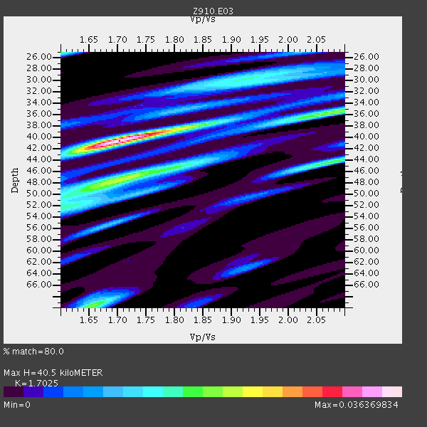
| Crust2 Type: | C4,continental shelf, 3.5 km seds. |
| Thickness Estimate: | 40 km |
| Thickness StdDev: | 5.8 km |
| Vp/Vs Estimate: | 1.70 |
| Vp/Vs StdDev: | 0.07 |
| Vs Estimate: | 3.518 km/s |
| Poisson's Ratio: | 0.24 |
| Peak Value: | 0.04 |
| Assumed Vp: | 5.989 km/s |
| Ps Weight: | 0.33333334 |
| PpPs Weight: | 0.33333334 |
| PsPs Weight: | 0.33333328 |
| Residual Complexity: | 0.742 |
| Nearby stations H: | +- |
| (2.0 deg) Vp/Vs: | +- |
4 with match > 90% ( 11.111111 %) and 6 with match > 80% ( 16.666666 %) out of 36.
Download stack as xyz text file.
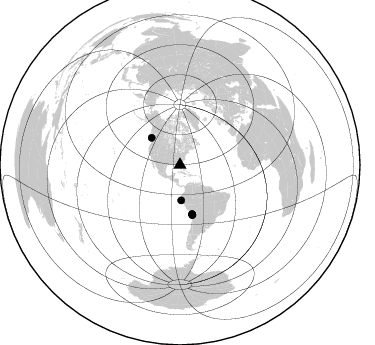
Azimuth Distribution of Events:
Prior Results for this Station
| Study | Thickness | Vp/Vs | Vp | Vs | Poissons Ratio | Extra |
| EARS | 40 km | 1.70 | 5.989 km/s | 3.518 km/s | 0.24 | |
| Crust2.0 | 32 km | 1.81 | 5.989 km/s | 3.317 km/s | 0.28 | C4,continental shelf, 3.5 km seds. |
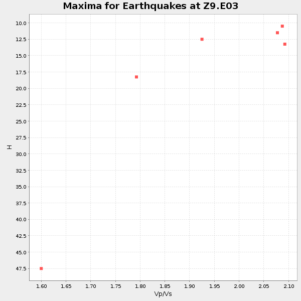
| Global Maxima | 40 km | 1.70 | 5.989 km/s | 3.518 km/s | 0.24 | amp=0.036369834 |
| Local Maxima 1 | 47 km | 1.71 | 5.989 km/s | 3.513 km/s | 0.24 | amp=0.021588992 |
| Local Maxima 2 | 70 km | 1.65 | 5.989 km/s | 3.619 km/s | 0.21 | amp=0.019575728 |
| Local Maxima 3 | 44 km | 2.07 | 5.989 km/s | 2.89 km/s | 0.35 | amp=0.017286697 |
| Local Maxima 4 | 25 km | 1.60 | 5.989 km/s | 3.743 km/s | 0.18 | amp=0.016448636 |
| Predicted Arrivals for vertical incidence (zero ray parameter) | |
| Ps | 4.75 SECOND |
| PpPs | 18.28 SECOND |
| PsPs/PpSs | 23.03 SECOND |
Events Processed for this Station
Download zip of receiver functions as SAC
Plot maxima for each earthquake.
Events Used in the Stack
(6 events)| Radial Match | Distance | Baz | FERegion | Time | Lat/Lon | Depth | Magnitude |
| 95.195 | 51.0 deg | 165.979 deg | Near Coast Of Northern Chile | 2014/04/03 01:58:31 GMT | (-20.3, -70.6) | 23 km | 6.5 MWW, 6.5 MWB, 6.6 MWC |
| 93.97693 | 39.4 deg | 313.521 deg | Vancouver Island, Canada Region | 2014/04/24 03:10:13 GMT | (49.8, -127.4) | 11 km | 6.7 MWP, 6.7 MI |
| 91.53252 | 50.7 deg | 165.965 deg | Near Coast Of Northern Chile | 2014/03/16 21:16:30 GMT | (-19.9, -70.6) | 20 km | 6.7 MWW, 6.7 MWC, 7.0 MI |
| 91.32202 | 51.3 deg | 166.294 deg | Near Coast Of Northern Chile | 2014/04/04 01:37:51 GMT | (-20.6, -70.7) | 20 km | 6.1 MWP, 6.1 MWB, 6.1 MWW, 6.3 MWC |
| 87.35212 | 35.2 deg | 177.972 deg | Near Coast Of Northern Peru | 2014/03/15 23:51:33 GMT | (-5.6, -81.0) | 29 km | 6.3 MWW, 6.2 MWB, 6.3 MWC |
| 84.15938 | 50.5 deg | 166.211 deg | Near Coast Of Northern Chile | 2014/03/22 12:59:59 GMT | (-19.8, -70.9) | 20 km | 6.2 MWW, 6.2 MWB, 6.3 MWC, 6.4 MWC |
Losers
(30 events)| Radial Match | Distance | Baz | FERegion | Time | Lat/Lon | Depth | Magnitude | Reason |
| 97.98528 | 50.4 deg | 166.109 deg | Near Coast Of Northern Chile | 2014/04/01 23:46:46 GMT | (-19.6, -70.8) | 20 km | 8.2 MWW, 8.0 MI, 8.1 MWC | |
| 93.748795 | 51.3 deg | 165.983 deg | Near Coast Of Northern Chile | 2014/04/03 02:43:14 GMT | (-20.5, -70.5) | 31 km | 7.7 MWW, 7.4 MI, 7.7 MWC | |
| 88.47514 | 36.4 deg | 299.371 deg | Off Coast Of Northern California | 2014/03/10 05:18:13 GMT | (40.8, -125.1) | 17 km | 6.8 MW, 6.8 MWR, 6.9 MWW, 6.9 MWB, 7.0 MI, 7.0 MWC | |
| 79.42846 | 50.8 deg | 165.971 deg | Near Coast Of Northern Chile | 2014/04/02 00:37:49 GMT | (-20.0, -70.6) | 20 km | 5.4 mb | |
| 75.013985 | 50.5 deg | 166.131 deg | Near Coast Of Northern Chile | 2014/03/23 18:20:03 GMT | (-19.7, -70.8) | 35 km | 6.0 MB, 6.2 MWB, 6.2 MWW, 6.3 MWC | |
| 73.05494 | 44.2 deg | 170.894 deg | Near Coast Of Peru | 2014/02/18 23:35:58 GMT | (-14.2, -75.6) | 57 km | 6.0 MWB, 5.9 MWW, 5.9 MWC, 6.0 MWC | |
| 73.033295 | 50.4 deg | 165.716 deg | Near Coast Of Northern Chile | 2014/04/02 00:04:54 GMT | (-19.6, -70.5) | 34 km | 5.5 MB | |
| 66.5291 | 66.4 deg | 319.437 deg | Fox Islands, Aleutian Islands | 2014/02/26 21:13:40 GMT | (53.6, -171.8) | 265 km | 6.1 MWW, 5.9 MI, 5.9 ML, 6.1 MWC, 6.1 MWB, 6.2 MWC | |
| 64.89565 | 44.0 deg | 171.858 deg | Near Coast Of Peru | 2014/03/15 08:59:21 GMT | (-14.1, -76.3) | 20 km | 6.1 MWW, 6.0 MWB, 6.2 MWC | |
| 62.749767 | 50.9 deg | 166.295 deg | Near Coast Of Northern Chile | 2014/04/02 04:46:18 GMT | (-20.2, -70.9) | 10 km | 5.8 MB | |
| 61.66305 | 51.3 deg | 166.239 deg | Near Coast Of Northern Chile | 2014/04/03 09:23:21 GMT | (-20.6, -70.7) | 15 km | 5.6 MB, 5.3 MWR | |
| 60.44661 | 50.6 deg | 166.369 deg | Near Coast Of Northern Chile | 2014/04/02 04:19:48 GMT | (-19.9, -71.0) | 16 km | 5.1 mb | |
| 58.84041 | 51.9 deg | 157.951 deg | Southern Bolivia | 2014/01/27 16:42:37 GMT | (-19.3, -63.9) | 600 km | 5.6 MWB | |
| 58.47471 | 69.0 deg | 49.988 deg | France | 2014/04/07 19:27:00 GMT | (44.5, 6.7) | 9.1 km | 5.0 MW | |
| 56.68144 | 51.9 deg | 165.226 deg | Northern Chile | 2014/01/07 03:43:23 GMT | (-21.0, -69.7) | 87 km | 5.4 MW | |
| 56.662853 | 51.5 deg | 166.206 deg | Near Coast Of Northern Chile | 2014/01/08 04:22:10 GMT | (-20.7, -70.6) | 20 km | 5.7 MWW, 5.6 MWB, 5.6 MWR, 5.7 MWC | |
| 56.376667 | 51.1 deg | 166.498 deg | Near Coast Of Northern Chile | 2014/04/06 14:06:09 GMT | (-20.4, -71.0) | 20 km | 5.3 MW | |
| 55.312138 | 54.8 deg | 324.679 deg | Southern Alaska | 2014/05/10 14:16:08 GMT | (60.0, -152.2) | 96 km | 5.8 ML, 5.5 MI, 5.7 MWP | |
| 54.356377 | 78.4 deg | 113.749 deg | Southern Mid-Atlantic Ridge | 2014/02/20 04:09:57 GMT | (-14.1, -14.6) | 14 km | 5.1 MW | |
| 48.27762 | 50.7 deg | 166.086 deg | Near Coast Of Northern Chile | 2014/03/17 00:12:11 GMT | (-20.0, -70.7) | 19 km | 5.1 mb | |
| 46.564922 | 70.4 deg | 354.398 deg | East Of Severnaya Zemlya | 2014/01/14 03:43:05 GMT | (78.8, 126.0) | 10 km | 4.1 mb | |
| 42.22746 | 71.4 deg | 318.803 deg | Andreanof Islands, Aleutian Is. | 2014/03/13 13:20:59 GMT | (51.2, -179.1) | 26 km | 5.6 MWC, 5.1 ML, 5.4 MWW, 5.4 MWB, 5.5 ML, 5.6 MWC | |
| 41.21541 | 55.0 deg | 165.527 deg | Northern Chile | 2014/03/20 18:41:32 GMT | (-24.0, -69.2) | 96 km | 5.1 MW | |
| 40.557194 | 50.6 deg | 166.099 deg | Near Coast Of Northern Chile | 2014/03/24 11:26:39 GMT | (-19.8, -70.8) | 22 km | 5.7 MWW, 5.7 MWB, 5.8 MWC | |
| 40.191185 | 51.3 deg | 166.547 deg | Near Coast Of Northern Chile | 2014/04/11 08:39:43 GMT | (-20.6, -71.0) | 13 km | 4.9 mb | |
| 38.789856 | 75.4 deg | 175.7 deg | Off Coast Of Southern Chile | 2014/03/02 17:03:43 GMT | (-45.8, -76.2) | 10 km | 5.4 MW | |
| 38.622684 | 65.0 deg | 170.604 deg | Near Coast Of Central Chile | 2014/03/15 14:46:28 GMT | (-34.7, -71.8) | 45 km | 5.5 MB, 5.1 MWW | |
| 37.113564 | 51.2 deg | 166.04 deg | Near Coast Of Northern Chile | 2014/04/02 19:45:49 GMT | (-20.4, -70.6) | 17 km | 5.3 MW | |
| 34.08202 | 83.8 deg | 50.544 deg | Southern Greece | 2014/04/04 20:08:07 GMT | (37.2, 23.8) | 107 km | 5.5 MWB, 5.5 MWR, 5.6 MWC, 5.6 MWW | |
| 24.841267 | 51.2 deg | 166.484 deg | Near Coast Of Northern Chile | 2014/04/08 10:14:32 GMT | (-20.5, -70.9) | 7.1 km | 5.7 MWB, 5.5 MWR, 5.6 MWC, 5.6 MWW |

