
Station Z9 E04 - Moody Farm, Lawtey, Florida
Network: Z910 - Southeastern Suture of the Appalachian Margin Experiment
Nearby stations (2 deg radius)
| Station | Name | (Lat, Lon) | Start / End | Elevation |
| E04 | Moody Farm, Lawtey, Florida | (30.03, -82.11) | 2012-09-15 / 2014-05-15 | 48 m |
| Crust2 Type: | DG,thin Platform 1 km seds. |
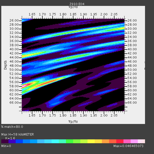
| Thickness Estimate: | 58 km |
| Thickness StdDev: | 11 km |
| Vp/Vs Estimate: | 1.60 |
| Vp/Vs StdDev: | 0.18 |
| Vs Estimate: | 4.103 km/s |
| Poisson's Ratio: | 0.18 |
| Peak Value: | 0.05 |
| Assumed Vp: | 6.565 km/s |
| Ps Weight: | 0.33333334 |
| PpPs Weight: | 0.33333334 |
| PsPs Weight: | 0.33333328 |
| Residual Complexity: | 0.855 |
| Nearby stations H: | +- |
| (2.0 deg) Vp/Vs: | +- |
5 with match > 90% ( 14.705882 %) and 6 with match > 80% ( 17.647058 %) out of 34.
Download stack as xyz text file.
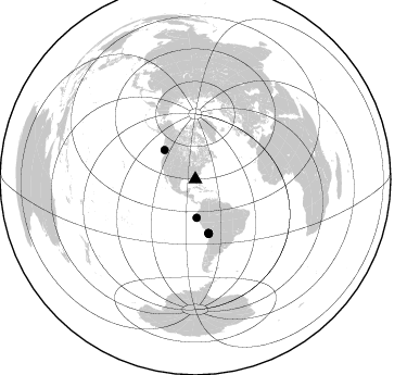
Azimuth Distribution of Events:
Prior Results for this Station
| Study | Thickness | Vp/Vs | Vp | Vs | Poissons Ratio | Extra |
| EARS | 58 km | 1.60 | 6.565 km/s | 4.103 km/s | 0.18 | |
| Crust2.0 | 31 km | 1.78 | 6.565 km/s | 3.684 km/s | 0.27 | DG,thin Platform 1 km seds. |
| Global Maxima | 58 km | 1.60 | 6.565 km/s | 4.103 km/s | 0.18 | amp=0.046465073 |
| Local Maxima 1 | 43 km | 1.60 | 6.565 km/s | 4.103 km/s | 0.18 | amp=0.032871008 |
| Local Maxima 2 | 58 km | 1.69 | 6.565 km/s | 3.896 km/s | 0.23 | amp=0.030537501 |
| Local Maxima 3 | 30 km | 2.10 | 6.565 km/s | 3.133 km/s | 0.35 | amp=0.030056436 |
| Local Maxima 4 | 44 km | 1.83 | 6.565 km/s | 3.592 km/s | 0.29 | amp=0.02637599 |
| Predicted Arrivals for vertical incidence (zero ray parameter) | |
| Ps | 5.30 SECOND |
| PpPs | 22.97 SECOND |
| PsPs/PpSs | 28.27 SECOND |
Events Processed for this Station
Download zip of receiver functions as SAC
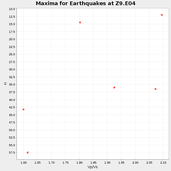
Plot maxima for each earthquake.
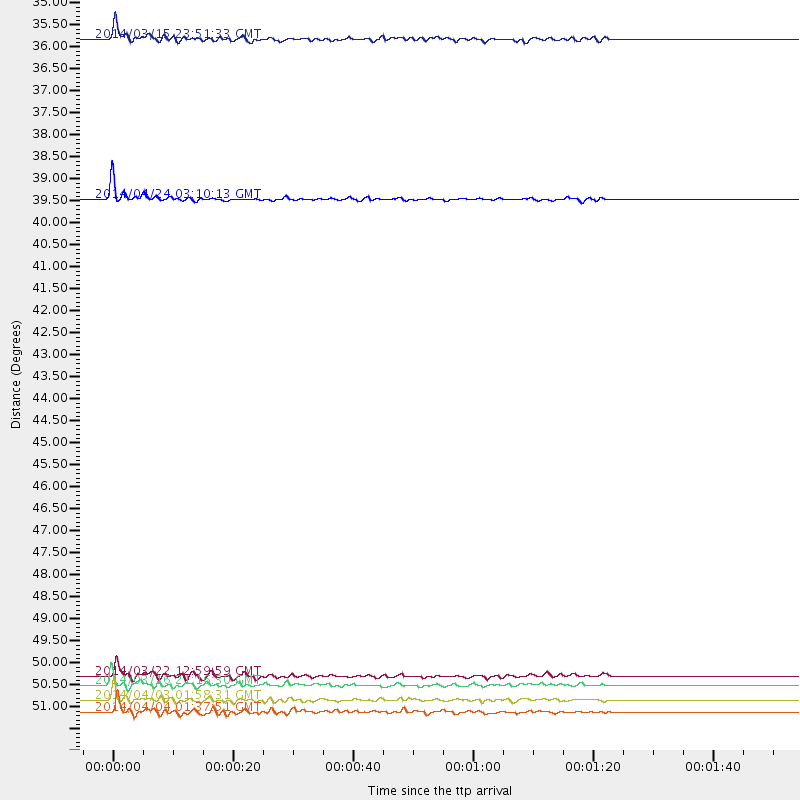
Events Used in the Stack
(6 events)| Radial Match | Distance | Baz | FERegion | Time | Lat/Lon | Depth | Magnitude |
| 94.35326 | 39.3 deg | 313.341 deg | Vancouver Island, Canada Region | 2014/04/24 03:10:13 GMT | (49.8, -127.4) | 11 km | 6.7 MWP, 6.7 MI |
| 92.78539 | 50.9 deg | 166.031 deg | Near Coast Of Northern Chile | 2014/03/16 21:16:30 GMT | (-19.9, -70.6) | 20 km | 6.7 MWW, 6.7 MWC, 7.0 MI |
| 92.62435 | 51.2 deg | 166.044 deg | Near Coast Of Northern Chile | 2014/04/03 01:58:31 GMT | (-20.3, -70.6) | 23 km | 6.5 MWW, 6.5 MWB, 6.6 MWC |
| 91.533966 | 50.7 deg | 166.276 deg | Near Coast Of Northern Chile | 2014/03/22 12:59:59 GMT | (-19.8, -70.9) | 20 km | 6.2 MWW, 6.2 MWB, 6.3 MWC, 6.4 MWC |
| 90.643074 | 51.5 deg | 166.358 deg | Near Coast Of Northern Chile | 2014/04/04 01:37:51 GMT | (-20.6, -70.7) | 20 km | 6.1 MWP, 6.1 MWB, 6.1 MWW, 6.3 MWC |
| 84.35906 | 35.4 deg | 178.02 deg | Near Coast Of Northern Peru | 2014/03/15 23:51:33 GMT | (-5.6, -81.0) | 29 km | 6.3 MWW, 6.2 MWB, 6.3 MWC |
Losers
(28 events)| Radial Match | Distance | Baz | FERegion | Time | Lat/Lon | Depth | Magnitude | Reason |
| 98.43321 | 50.6 deg | 166.175 deg | Near Coast Of Northern Chile | 2014/04/01 23:46:46 GMT | (-19.6, -70.8) | 20 km | 8.2 MWW, 8.0 MI, 8.1 MWC | |
| 94.59489 | 51.5 deg | 166.047 deg | Near Coast Of Northern Chile | 2014/04/03 02:43:14 GMT | (-20.5, -70.5) | 31 km | 7.7 MWW, 7.4 MI, 7.7 MWC | |
| 92.193985 | 36.4 deg | 299.136 deg | Off Coast Of Northern California | 2014/03/10 05:18:13 GMT | (40.8, -125.1) | 17 km | 6.8 MW, 6.8 MWR, 6.9 MWW, 6.9 MWB, 7.0 MI, 7.0 MWC | |
| 86.22797 | 50.6 deg | 165.782 deg | Near Coast Of Northern Chile | 2014/04/02 00:04:54 GMT | (-19.6, -70.5) | 34 km | 5.5 MB | |
| 80.11843 | 51.8 deg | 166.226 deg | Near Coast Of Northern Chile | 2014/04/03 05:28:50 GMT | (-20.8, -70.6) | 11 km | 5.6 mb | |
| 75.035255 | 50.6 deg | 166.161 deg | Near Coast Of Northern Chile | 2014/04/02 00:06:44 GMT | (-19.6, -70.8) | 10 km | 5.7 MB | |
| 73.427505 | 50.7 deg | 166.196 deg | Near Coast Of Northern Chile | 2014/03/23 18:20:03 GMT | (-19.7, -70.8) | 35 km | 6.0 MB, 6.2 MWB, 6.2 MWW, 6.3 MWC | |
| 73.15809 | 44.4 deg | 170.956 deg | Near Coast Of Peru | 2014/02/18 23:35:58 GMT | (-14.2, -75.6) | 57 km | 6.0 MWB, 5.9 MWW, 5.9 MWC, 6.0 MWC | |
| 67.20875 | 44.2 deg | 171.917 deg | Near Coast Of Peru | 2014/03/15 08:59:21 GMT | (-14.1, -76.3) | 20 km | 6.1 MWW, 6.0 MWB, 6.2 MWC | |
| 64.94246 | 41.3 deg | 217.819 deg | Central East Pacific Rise | 2014/01/07 23:02:53 GMT | (-4.5, -106.1) | 10 km | 5.7 MWB, 5.8 MWC | |
| 61.37904 | 50.9 deg | 166.445 deg | Near Coast Of Northern Chile | 2014/04/02 11:07:33 GMT | (-20.0, -71.0) | 27 km | 5.4 Mww | |
| 60.098145 | 51.5 deg | 166.303 deg | Near Coast Of Northern Chile | 2014/04/03 09:23:21 GMT | (-20.6, -70.7) | 15 km | 5.6 MB, 5.3 MWR | |
| 59.410046 | 54.6 deg | 324.598 deg | Southern Alaska | 2014/05/10 14:16:08 GMT | (60.0, -152.2) | 96 km | 5.8 ML, 5.5 MI, 5.7 MWP | |
| 59.04552 | 51.7 deg | 166.269 deg | Near Coast Of Northern Chile | 2014/01/08 04:22:10 GMT | (-20.7, -70.6) | 20 km | 5.7 MWW, 5.6 MWB, 5.6 MWR, 5.7 MWC | |
| 55.591873 | 68.2 deg | 196.567 deg | Southeast Of Easter Island | 2014/04/15 13:31:33 GMT | (-36.1, -101.2) | 14 km | 5.6 MW | |
| 54.86138 | 89.7 deg | 325.695 deg | Kuril Islands | 2014/01/06 07:27:20 GMT | (46.2, 152.1) | 100 km | 3.5 mb | |
| 53.11689 | 51.1 deg | 166.236 deg | Near Coast Of Northern Chile | 2014/04/15 16:21:17 GMT | (-20.2, -70.7) | 18 km | 5.1 MW | |
| 50.250412 | 61.1 deg | 214.148 deg | Easter Island Region | 2014/02/14 07:44:15 GMT | (-23.0, -114.3) | 12 km | 5.6 MWW, 5.5 MWB, 5.6 MWC | |
| 49.742027 | 51.1 deg | 166.359 deg | Near Coast Of Northern Chile | 2014/04/02 04:46:18 GMT | (-20.2, -70.9) | 10 km | 5.8 MB | |
| 46.765434 | 66.3 deg | 319.386 deg | Fox Islands, Aleutian Islands | 2014/02/26 21:13:40 GMT | (53.6, -171.8) | 265 km | 6.1 MWW, 5.9 MI, 5.9 ML, 6.1 MWC, 6.1 MWB, 6.2 MWC | |
| 46.287727 | 72.2 deg | 102.134 deg | North Of Ascension Island | 2014/04/30 15:52:42 GMT | (-1.2, -13.5) | 14 km | 5.8 MW | |
| 43.66207 | 52.0 deg | 158.034 deg | Southern Bolivia | 2014/01/27 16:42:37 GMT | (-19.3, -63.9) | 600 km | 5.6 MWB | |
| 39.12975 | 67.4 deg | 192.726 deg | West Chile Rise | 2014/05/06 20:52:29 GMT | (-36.3, -96.7) | 14 km | 5.9 MWB | |
| 38.859013 | 85.1 deg | 329.331 deg | Northwest Of Kuril Islands | 2014/03/12 18:18:40 GMT | (52.0, 153.2) | 418 km | 5.1 MW | |
| 33.676826 | 96.5 deg | 35.618 deg | Eastern Caucasus | 2014/02/10 12:06:46 GMT | (40.3, 48.8) | 63 km | 5.5 MW | |
| 33.512157 | 83.6 deg | 50.57 deg | Southern Greece | 2014/04/04 20:08:07 GMT | (37.2, 23.8) | 107 km | 5.5 MWB, 5.5 MWR, 5.6 MWC, 5.6 MWW | |
| 32.844578 | 50.8 deg | 166.299 deg | Near Coast Of Northern Chile | 2014/03/17 11:12:17 GMT | (-19.9, -70.9) | 26 km | 5.0 MW | |
| 28.429626 | 35.5 deg | 178.015 deg | Near Coast Of Northern Peru | 2014/03/22 00:38:45 GMT | (-5.6, -81.0) | 37 km | 4.9 mb |

