
Station Z9 E05 - Sigers Farm, Glen St. Mary, Florida
Network: Z910 - Southeastern Suture of the Appalachian Margin Experiment
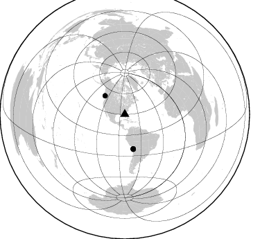
Nearby stations (2 deg radius)
| Station | Name | (Lat, Lon) | Start / End | Elevation |
| E05 | Sigers Farm, Glen St. Mary, Florida | (30.36, -82.12) | 2012-09-15 / 2014-05-15 | 29 m |
| Crust2 Type: | DG,thin Platform 1 km seds. |
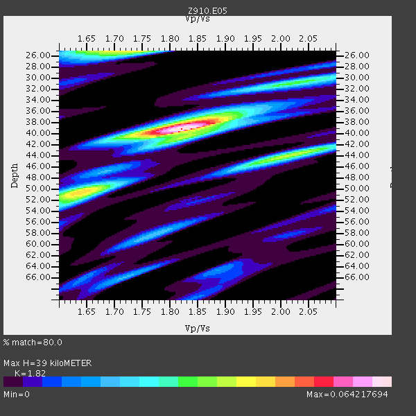
| Thickness Estimate: | 39 km |
| Thickness StdDev: | 5.8 km |
| Vp/Vs Estimate: | 1.82 |
| Vp/Vs StdDev: | 0.09 |
| Vs Estimate: | 3.607 km/s |
| Poisson's Ratio: | 0.28 |
| Peak Value: | 0.06 |
| Assumed Vp: | 6.565 km/s |
| Ps Weight: | 0.33333334 |
| PpPs Weight: | 0.33333334 |
| PsPs Weight: | 0.33333328 |
| Residual Complexity: | 0.662 |
| Nearby stations H: | +- |
| (2.0 deg) Vp/Vs: | +- |
2 with match > 90% ( 11.111111 %) and 4 with match > 80% ( 22.222221 %) out of 18.
Download stack as xyz text file.
Azimuth Distribution of Events:
Prior Results for this Station
| Study | Thickness | Vp/Vs | Vp | Vs | Poissons Ratio | Extra |
| EARS | 39 km | 1.82 | 6.565 km/s | 3.607 km/s | 0.28 | |
| Crust2.0 | 31 km | 1.78 | 6.565 km/s | 3.684 km/s | 0.27 | DG,thin Platform 1 km seds. |
| Global Maxima | 39 km | 1.82 | 6.565 km/s | 3.607 km/s | 0.28 | amp=0.064217694 |
| Local Maxima 1 | 50 km | 1.64 | 6.565 km/s | 4.009 km/s | 0.20 | amp=0.042623676 |
| Local Maxima 2 | 25 km | 1.72 | 6.565 km/s | 3.817 km/s | 0.24 | amp=0.041310526 |
| Local Maxima 3 | 43 km | 2.04 | 6.565 km/s | 3.226 km/s | 0.34 | amp=0.03095008 |
| Local Maxima 4 | 37 km | 1.86 | 6.565 km/s | 3.529 km/s | 0.30 | amp=0.024733523 |
| Predicted Arrivals for vertical incidence (zero ray parameter) | |
| Ps | 4.87 SECOND |
| PpPs | 16.75 SECOND |
| PsPs/PpSs | 21.63 SECOND |
Events Processed for this Station
Download zip of receiver functions as SAC
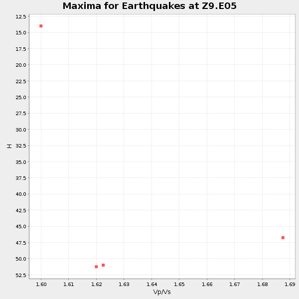
Plot maxima for each earthquake.
Events Used in the Stack
(4 events)| Radial Match | Distance | Baz | FERegion | Time | Lat/Lon | Depth | Magnitude |
| 94.78038 | 39.0 deg | 313.044 deg | Vancouver Island, Canada Region | 2014/04/24 03:10:13 GMT | (49.8, -127.4) | 11 km | 6.7 MWP, 6.7 MI |
| 90.80233 | 51.2 deg | 166.086 deg | Near Coast Of Northern Chile | 2014/03/16 21:16:30 GMT | (-19.9, -70.6) | 20 km | 6.7 MWW, 6.7 MWC, 7.0 MI |
| 87.52326 | 51.0 deg | 166.331 deg | Near Coast Of Northern Chile | 2014/03/22 12:59:59 GMT | (-19.8, -70.9) | 20 km | 6.2 MWW, 6.2 MWB, 6.3 MWC, 6.4 MWC |
| 87.17074 | 51.9 deg | 166.41 deg | Near Coast Of Northern Chile | 2014/04/04 01:37:51 GMT | (-20.6, -70.7) | 20 km | 6.1 MWP, 6.1 MWB, 6.1 MWW, 6.3 MWC |
Losers
(14 events)| Radial Match | Distance | Baz | FERegion | Time | Lat/Lon | Depth | Magnitude | Reason |
| 98.57169 | 50.9 deg | 166.23 deg | Near Coast Of Northern Chile | 2014/04/01 23:46:46 GMT | (-19.6, -70.8) | 20 km | 8.2 MWW, 8.0 MI, 8.1 MWC | |
| 95.52601 | 51.8 deg | 166.101 deg | Near Coast Of Northern Chile | 2014/04/03 02:43:14 GMT | (-20.5, -70.5) | 31 km | 7.7 MWW, 7.4 MI, 7.7 MWC | |
| 92.54896 | 36.2 deg | 298.739 deg | Off Coast Of Northern California | 2014/03/10 05:18:13 GMT | (40.8, -125.1) | 17 km | 6.8 MW, 6.8 MWR, 6.9 MWW, 6.9 MWB, 7.0 MI, 7.0 MWC | |
| 86.56619 | 51.0 deg | 166.45 deg | Near Coast Of Northern Chile | 2014/03/22 13:29:57 GMT | (-19.8, -71.0) | 10 km | 5.5 MB, 5.4 MWR, 5.6 MWW, 5.6 MWC | |
| 75.697 | 50.9 deg | 166.216 deg | Near Coast Of Northern Chile | 2014/04/02 00:06:44 GMT | (-19.6, -70.8) | 10 km | 5.7 MB | |
| 72.638985 | 51.1 deg | 166.307 deg | Near Coast Of Northern Chile | 2014/03/23 20:23:04 GMT | (-19.9, -70.8) | 23 km | 5.3 MW | |
| 69.43775 | 50.6 deg | 166.078 deg | Near Coast Of Northern Chile | 2014/04/02 02:52:26 GMT | (-19.3, -70.8) | 17 km | 4.9 mb | |
| 64.5253 | 52.0 deg | 166.427 deg | Near Coast Of Northern Chile | 2014/04/11 00:01:44 GMT | (-20.7, -70.7) | 18 km | 6.0 MB | |
| 64.363106 | 74.6 deg | 177.884 deg | Off Coast Of Southern Chile | 2014/01/07 12:06:13 GMT | (-44.5, -79.3) | 35 km | 5.2 MW | |
| 63.940998 | 51.9 deg | 166.493 deg | Near Coast Of Northern Chile | 2014/01/04 00:11:48 GMT | (-20.7, -70.8) | 26 km | 5.7 MWW, 5.8 MWB, 5.8 MWC | |
| 56.549133 | 75.9 deg | 175.721 deg | Off Coast Of Southern Chile | 2014/03/02 17:03:43 GMT | (-45.8, -76.2) | 10 km | 5.4 MW | |
| 55.530888 | 72.5 deg | 350.69 deg | Laptev Sea | 2014/04/11 13:27:05 GMT | (74.9, 133.8) | 10 km | 4.2 mb | |
| 52.74817 | 83.4 deg | 50.596 deg | Southern Greece | 2014/04/04 20:08:07 GMT | (37.2, 23.8) | 107 km | 5.5 MWB, 5.5 MWR, 5.6 MWC, 5.6 MWW | |
| 52.066437 | 86.1 deg | 329.952 deg | Sea Of Okhotsk | 2014/01/15 06:55:09 GMT | (51.5, 151.0) | 551 km | 4.6 mb |

